Ujae
| Ujae | ||
|---|---|---|
 | ||
| Gewässer | Pazifischer Ozean | |
| Archipel | Marshallinseln | |
| Geographische Lage | 9° 0′ N, 165° 4′ O9165.06666666667Koordinaten: 9° 0′ N, 165° 4′ O | |
| ||
| Anzahl der Inseln | 15 | |
| Hauptinsel | Ujae | |
| Landfläche | 1,86 km² | |
| Lagunenfläche | 185,94dep1 | |
| Einwohner | 310 (2021) | |
 | ||


Vorlage:Infobox Atoll/Wartung/HoeheFehlt
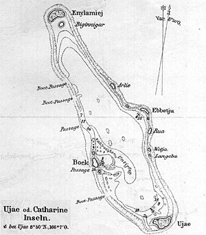
Ujae (deutsch veraltet: Katharineinseln bzw. Margareteninseln[1], auch: Ujamilai, Milai oder Serpent Island) ist ein Atoll der Ralik-Kette der Marshallinseln. Das Atoll hat eine Landfläche von 1,86 km², die eine Lagune von 186 km² umschließt. Das Atoll liegt 630 km nordwestlich der Hauptstadt der Marshallinseln Majuro.
Im Jahre 2021 hatte das Atoll 310 Einwohner.[2]
Weblinks
- Geographische Informationen (engl.)
Einzelnachweise
- ↑ Stichwort: Ujae. Online in: Deutsches Kolonial-Lexikon, Band III, Leipzig 1920, S. 569.
- ↑ Republic of the Marshall Islands 2021 Census Report. Band 1: Basic Tables and Administrative Report. Secretariat of the Pacific Community, 2023, Table 3: Population by Urban/Rural and atoll by sex, S. 10 (englisch, Downloadlink auf sdd.spc.int [PDF; 3,9 MB; abgerufen am 16. Juni 2024]).

Atolle und Einzel-Inseln der Marshallinseln
Ratak-Kette: Ailuk | Arno-Atoll | Aur | Bikar | Bokak | Erikub | Knox-Atoll | Likiep | Majuro-Atoll | Maloelap | Mili | Toke | Utirik | Wotje
Keinem Atoll zugehörige Inseln: Jemo | Mejit
Ralik-Kette: Ailinginae | Ailinglaplap | Bikini-Atoll | Ebon-Atoll | Eniwetok | Jaluit | Kwajalein | Lae-Atoll | Namorik | Namu | Rongdrik | Rongelap-Atoll | Ujae | Ujelang | Wotho
Keinem Atoll zugehörige Inseln: Jabwot | Kili | Lib
Beansprucht: Wake


