Anangpur
A historical village located near Faridabad in Haryana, India


Location in Haryana, India, Asia
Show map of Haryana
Anangpur (India)
Show map of IndiaAnangpur is a historical village located near Faridabad in Haryana, India. Anangpur forms a geographical triangle along with Mehrauli and Tugluqabad. It was the earliest settlement of the Tanwar dynasty. Anangpur was the capital of the Tanwar king, Anangpal Tanwar I, who had built the fort and monuments here.[1][2][3][4][5]
History
Tomara dynasty (8th - 11th century CE)
Anangpal I, first king of Tanwar dynasty (c.736- 1052 CE), declared himself an independent ruler and established the Tanwar Dynasty of Delhi in the early 8th century.[6] He built his capital in this village and expanded his kingdom from there. He is said to have built numerous palaces and temples during his reign, the majority of which are diminished now.[1] Last king of this dynasty was Anangpal Tanwar (Anangpal II), who had built Delhi's Lal Kot, which was later renovated by Chauhan ruler and also came to be known as the Qila Rai Pithora. Tanwar dynasty were overthrown by Chahamanas of Shakambhari, last Chahamana or Chauhan king was Prithviraj Chauhan, Qila Rai Pithora (earlier called Lal Kot) is named after him.[citation needed]
The capital of Tanwar changed a few times during the course of 457 years they ruled in the northern India. The first capital of the Tomar empire was Anangpur while the last one was Dhillikapuri (Delhi, Lal Kot).[7]
Chauhan dynasty (12th century CE)
The Tomara's rule was followed by that of the Chahamanas and the mlechchha Sahavadina (Shihab ad-Din).[8]
Paleolithic sites (100,000 BP)
| The Paleolithic |
|---|
| ↑ Pliocene (before Homo) |
|
Europe:
|
| ↓ Mesolithic |
|
Part of a series on the |
|---|
| History of India |
 |
| Timeline |
| Prehistoric
|
| Ancient
|
|
|
|
| Early modern
|
| Modern
|
| Related articles
|
|
Group of 43 sites
Anangpur Group of Paleolithic Sites (AGPS): Discovered in 1986, - Mangar Bani near Delhi may extend AGPS, dating back to the **Mesolithic and Paleolithic eras. Mangar Bani: Located in the Aravalli hills, Mangar Bani houses ancient rock paintings and tools and is under advocacy for its biodiversity and historical value. Tools and Artifacts: The tools found follow an Acheulean tradition, with Mangar Bani being among the largest Paleolithic sites in Asia.
Anangpur group of paleolithic sites (AGPS), discovered In 1986, is a cluster of 43 prehistoric sites with rock art (paintings) in the area of historic Anangpur village, Mangar Bani paleolithic site found in 2021 might be an extension of Anangpur sites.[9]
In the forested area where the Surajkund and the Anagpur Dam are located, ancient Stone Age relics have been found which are microliths (stone tools) belonging to the lower paleolithic era.[10] From a study of the prehistoric findings along the ridges of Surajkund reservoir, Anagpur Dam, and around Delhi and adjoining parts of Haryana, it has been inferred that the southern hilly area of Delhi and Haryana was environmentally suited for pre-historic man to settle here.[11]
List of sites
These were found at 43 sites from Ankhir (a village 17 km east of Mangar Bani) in south to north along the Anangpur-Angnpur Dam-Surajkund-Tughlaqabad axis. These sites are on the 'Tughlaqabad-Surajkund Road' and south of 'Surajkund-Faridabad Road', on Anangpur hills, and on Ankhir hill, and on the road embracing the low ridge from Faridabad (Ankhir) to Surajkund.[10] These sites include Ankhir, Anangpur, Anangpur Dam, Shilakhari, Mangar Bani, Dhauj, Kot, Roj ka Gujjar, Nurpur, Dhumaspur, Surajkund, etc.[9]
One of these sites is at Kot village, northeast of Sohna and southwest of Dhauj, where prehistoric paintings on stones and tools, such as chisel, have been found. Haryana surveyed the site in 2021 and ASI surveyed and photographed the site in June 2023.[12]
Protected status
As of 31 July 2021, Head of HAD, Ashok Khemka, informed that proposal to notify this entire area as protected archaeological site has been sent by Haryana Archaeological Dept (HAD) to Govt of Haryana (GoH), and HAD is awaiting gazette notification by the GoH after which this site will become legally protected. Meanwhile, district land and revenue administration of Faridabad was undertaking ground truthing exercise, to verify the data, to ascertain the landscape and confirm the type and ownership of the land, which will be sent to HAD to help with attainment of protected status and consequent conservation.[9]
Conservation
Khemka asserted that HAD will engage National Research Laboratory for Conservation of Cultural Property (NRLC) Lucknow, Birbal Sahni Institute of Palaeosciences (BSIP) Lucknow, Physical Research Laboratory (PRL) Ahmedabad for conservation of rockart and paintings. Khemka asserted that the whole area will be extensively surveyed to find any additional sites, entire area of Delhi South Ridge of Aravali in Haryana between Gurugram and Faridabad will be mapped and each site will be GPS tagged. Large scale scientific excavations, scientific dating of paintings and excavated sediments will be undertaken.[9]
Other similar sites
Misolithic sites with tools, cave art and paintings are Anangpur caves and Mangar Bani Caves (Gurugram) in Delhi NCR, Bhimbetka rock shelters (Bhopal) and Pahargarh caves (Morena) in Madhya Pradesh.
Tomara monuments (8th-11th century CE)
Tomara dynasty ruled from here, they made Anangpur as their capital and constructed several monuments here.
- Capital forts/palaces in Delhi, oldest first
- Purana Qila, earliest Hindu rulers
- Indraprastha, earlier than 1000 BCE
- Edicts & additions by Ashoka the Great (r. 268 to 232 BCE) of Maurya Empire
- Purana Qila, earliest Hindu rulers
- Anangpur, by Anangpal I of Tomara dynasty (r. 736-1152 CE)
- Qila Rai Pithora,
- Lal Kot, by Tomara dynasty (1152-1177 CE) as capital
- Qila Rai Pithora, Lal Kot expended by Prithviraj Chauhan (also called Rai Pithora, r. 1177–92 CE) of Chauhan dynasty
- Qila Rai Pithora,
- Siri Fort, by Alauddin Khalji (r. 1296–1316), second ruler of Khalji Dynasty
- Tughlaqabad Fort, by Ghiyassudin Tughluq (r. 1320-25 CE) of Tughluq dynasty
- Feroz Shah Kotla, by Feroz Shah Tughluq (r. 1351-88 CE) of Tughluq dynasty
- Salimgarh Fort, in 1546 CE by Salim Shah Suri (r. 1545-54 CE), son of Sher Shah Suri
- Red fort, built in 1639-48 CE by Mughal emperor Shah Jahan when he moved his capital from Agra to Delhi
- Rashtrapati Bhavan, built in 1912-29 by colonial British raj
Anangpur Dam (8th century CE)
Anangpur Dam is an Indian hydraulic engineering structure built during his reign and the ruins of a fortification can also be seen around it. Surajkund, a large masonry tank, can be found in this area dating from the 9th century and was used to collect water from the Anangpur Dam and the surrounding areal.[13][14]
-
 Downstream view of the dam.
 -
 Top view of the dam, entry holes dam of the gallery inside the dam wall.
 -
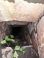 Top view of the dam, steps into the gallery inside the dam.
 -
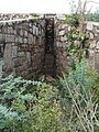 Sluice inlet in the dam - on upstream side of the dam while looking from upstream towards downstream.
 -
 Sluice outlet from the dam - on upstream side of the dam while looking from downstream side towards upstream.


Surajkund
Surajkund, a 10th century reservoir on Southern Delhi Ridge of Aravalli range in Faridabad, was built by the king Surajpal of the Tomara dynasty in the 10th century. Surajpal Tomar, a younger son of Anangpal Tomar - the ruler of Delhi, was a sun worshipper and he had therefore built a Sun temple on its western bank.[15][16][17][18]
Surajkund is known for its annual fair Surajkund International Craft Mela, 2015 edition of this fair was visited by 1.2 million visitors including 160,000 foreigners with more than 20 countries participating in it.[19]
-
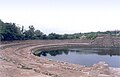 Suraj Kund panorama.
 -
 Suraj Kund - view.
 -
 Suraj Kund - another view.
 -
 Surajkund International Crafts Fair
 -
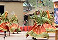 Rakasthani folk dance at Surajkund International Crafts Fair


Present day Anangpur village
Administration and demography
Present Anangpur (Postal Index Number 121003[20]) has a population of around 30000+ people, an area of 10.55 square kilometers, and a population density of 3332 per Kilometer square. The population consists mainly of Gurjar Community . This Village has Majority of Bhadana Gotra Gurjar. There are other gotra of gurjar like tanwar gurjar(only 10 houses) and chhawadi gurjar(only 10,12 houses) The largest mohalla of Anangpur is GhatiTala.[21]
Hari Parbat Mandir
Anangpur has a replica of the temple of Mata Sharika Chakreshwar Hari Parbat Srinagar. Hari Parbat Mandir Anangpur is situated at one of the hillocks adjoining the Anangpur village. The temple was built with the contribution of Padma Shri Jagan Nath Kaul, who was the President of the Kashmiri Sewak Samaj, Faridabad and All India Kashmiri Samaj.[22] The temple 'Hari Parbat' Anangpur is a place where 'Kashmiri Pandits' in and around Delhi observe their 'Nav Reh' festival.[23][24]
-
![a replica of the temple of [[Hari Parbat|Mata Sharika Chakreshwar Hari Parbat Srinagar]]](//upload.wikimedia.org/wikipedia/commons/thumb/0/06/Hari_Parbat_Anangpur.jpg/90px-Hari_Parbat_Anangpur.jpg) Sharika Devi temple, Hari Parbat Anangpur.
Sharika Devi temple, Hari Parbat Anangpur. -
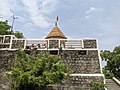 Hari Parbat Anangpur Faridabad.
 -
 Mata temple Hari Parbat Anangpur Faridabad.
 -
 The way to Hari Parbat Anangpur
![a replica of the temple of [[Hari Parbat|Mata Sharika Chakreshwar Hari Parbat Srinagar]]](http://upload.wikimedia.org/wikipedia/commons/thumb/0/06/Hari_Parbat_Anangpur.jpg/90px-Hari_Parbat_Anangpur.jpg)


See also
References
Citations
- ^ a b Bhāratī. Bharati Mahavidyalaya. 1992. pp. 129, 130, 131.
- ^ Sharma, Arun Kumar (1993). Prehistoric Delhi and Its Neighbourhood. Aryan Books International. ISBN 978-81-7305-016-9.
The palaeolithic site of Anangpur (Arangpur - 28°27 ' 30 " N . , 15°56 " E), district Faridabad in Haryana State of India is located nearly 30 kms . south of Delhi beyond Surajkund lake.
- ^ "Tomara dynasty | Indian dynasty". Encyclopedia Britannica. Retrieved 17 June 2021.
- ^ Sabha, India Parliament Lok (1995). Lok Sabha Debates. Lok Sabha Secretariat. p. 33.
- ^ "Indiaclub.com Search Results - ProductID: 8780". 31 August 2005. Archived from the original on 31 August 2005. Retrieved 17 June 2021.
- ^ Thapliyal, Uma Prasad (1987). Gazetteer of Rural Delhi. Gazetteer Unit, Delhi Administration. p. 413.
- ^ Tanwars of Delhi by Harihar Niwas Dwivedi. Gwalior: Vidya Mandir Publications. 1983.
- ^ D. C. Ganguly 1981, p. 704.
- ^ a b c d Rush for protected tag to Faridabad site where stone age cave art found, Times of India, 31 July 2021.
- ^ a b Singh, Upinder (2007). Delhi: Ancient History. Berghahn Books. pp. 6–7 in 227. ISBN 9788187358299.
{{cite book}}:|work=ignored (help) - ^ Singh p.185
- ^ फरीदाबाद: पत्थर की कुल्हाड़ी, शैलचित्र... पुरातत्व सर्वेक्षण की टीम को अरावली में मिले हजारों साल पुराने चिह्न, NavBharat Times, 18 June 2023.
- ^ Delhi City Guide. Eicher Goodearth Limited. 1998. p. 200. ISBN 978-81-900601-2-7.
- ^ Singh, Upinder (2006). Delhi: Ancient History. Berghahn Books. ISBN 978-81-87358-29-9.
- ^ "Ticketed Monuments – Haryana: Suraj Kund". National Informatics Centre, Government of India. Retrieved 5 September 2009.
- ^ Peck, Lucy (2005). Delhi - A thousand years of Building. New Delhi: Roli Books Pvt Ltd. p. 29. ISBN 81-7436-354-8. Retrieved 5 September 2009.
{{cite book}}:|work=ignored (help) - ^ "The Fair". Retrieved 5 September 2009.
- ^ Sharma, Y.D (2001). Delhi and its Neighbourhood. New Delhi: Archaeological Survey of India. p. 100 in 161. Archived from the original on 31 August 2005. Retrieved 5 September 2009.
Page 100: Suraj Kund lies about 3 km south-east of Tughlaqabad in district Gurgaon---The reservoir is believed to have been constructed in the tenth century by King Surjapal of Tomar dynasty. Page 101: About 2 km south-west of Surajkund, close to the village of Anagpur (also called Arangpur) is a dam ascribed to Anagpal of the Tomar Dynasty, who is also credited with building the Lal Kot
{{cite book}}:|work=ignored (help) - ^ "29th Surajkund International Crafts Mela Ends". Ndtv.com. Retrieved 31 October 2015.
- ^ "Pin Code: 121003, List of Post Offices, FARIDABAD, HARYANA Pincode.net.in". pincode.net.in. Retrieved 17 June 2021.
- ^ "Anangpur Village, Faridabad | Locality | GeoIQ". geoiq.io. Retrieved 17 June 2021.
- ^ "Remembering Padmashri Jagan Nath Kaul – Kashmir Sentinel". Retrieved 16 June 2021.
- ^ Toshakhānī, Śaśiśekhara (2010). Rites and Rituals of Kashmiri Brahmins. Pentagon Press. p. 152. ISBN 978-81-8274-475-2.
- ^ Dhar, Triloki Nath (1 January 2006). Kashmiri Pandit Community: A Profile. Mittal Publications. p. 74. ISBN 978-81-8324-177-9.
Bibliography
- D. C. Ganguly (1981). R. S. Sharma (ed.). A Comprehensive History of India (A. D. 300-985). Vol. 3, Part 1. Indian History Congress / Orient Longmans.

Protected areas of Haryana | ||
|---|---|---|
| National Parks |  | |
| Wildlife Sanctuaries |
| |
| Conservation Reserves |
| |
| Deer Parks | ||
| Zoo |
| |
| Breeding Centres | ||
| ||


| ||
|---|---|---|
 | ||


| |||||||||||||||||||||||||||||||||||||||||||||||
|---|---|---|---|---|---|---|---|---|---|---|---|---|---|---|---|---|---|---|---|---|---|---|---|---|---|---|---|---|---|---|---|---|---|---|---|---|---|---|---|---|---|---|---|---|---|---|---|
| Topics | |||||||||||||||||||||||||||||||||||||||||||||||
| Districts and divisions |
| ||||||||||||||||||||||||||||||||||||||||||||||
| Major cities | |||||||||||||||||||||||||||||||||||||||||||||||
| Culture | |||||||||||||||||||||||||||||||||||||||||||||||
| Economy |
| ||||||||||||||||||||||||||||||||||||||||||||||
| |||||||||||||||||||||||||||||||||||||||||||||||
| |||||||||||||||||||||||||||||||||||||||||||||||
| |||||||||||||||||||||||||||||||||||||||||||||||
| |||||||||||||||||||||||||||||||||||||||||||||||

| |||||||||||||||||||
|---|---|---|---|---|---|---|---|---|---|---|---|---|---|---|---|---|---|---|---|
| Topics | |||||||||||||||||||
| History |
| ||||||||||||||||||
| Government and administration |
| ||||||||||||||||||
| Places of interest |
| ||||||||||||||||||
| Geography and divisions |
| ||||||||||||||||||
| Transport |
| ||||||||||||||||||
| Sports |
| ||||||||||||||||||
| Culture |
| ||||||||||||||||||
| Other templates |
| ||||||||||||||||||
| Related |
| ||||||||||||||||||
| |||||||||||||||||||


