List of ghost towns in Colorado
List of ghost towns in the U.S. State of Colorado

This is a list of some notable ghost towns in the U.S. State of Colorado. A ghost town is a former community that now has no year-round residents or less than 1% of its peak population. Colorado has over 1,500 ghost towns, although visible remains of only about 640 still exist. Due to incomplete records, no exhaustive list can be produced.
Abandonment
Colorado ghost towns were abandoned for a number of reasons:
- Mining towns were abandoned when the mines closed; many due to the devaluation of silver in 1893.
- Mill towns were abandoned when the mining towns they serviced closed.
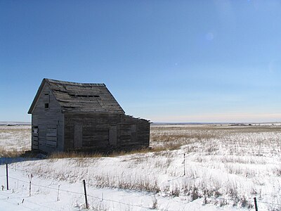
- Farming towns on the eastern plains were often deserted due to rural depopulation.
- Coal towns were abandoned when the coal (or the need for it) ran out.
- Stage stops were abandoned when the railroad came through.
- Rail stops were deserted when the railroad changed routes or abandoned the spurs.
Others were abandoned for more unusual reasons. Some were resort towns which never brought in enough tourists. At least seven former townsites are now underwater, caused by the creation of reservoirs; a few are covered in mining tailings, as noted below. Of the list below, some involve settlements with visible tangible remains such as structures or cemeteries, while the precise location of others is known only through maps and historic accounts.
Table
Map all coordinates using OpenStreetMap
Download coordinates as:
- KML
- GPX (all coordinates)
- GPX (primary coordinates)
- GPX (secondary coordinates)
This is a sortable table of some of the ghost towns in Colorado. Select the OpenStreetMap link in the box at right to view a map showing the location these towns.
| Ghost town | Other names | Current county | Location[1] | Elevation[1] | Established | Abandoned | Industry | Status |
|---|---|---|---|---|---|---|---|---|
| Abbeyville | Gunnison | 38°46′39″N 106°29′32″W / 38.7775°N 106.4922°W / 38.7775; -106.4922 (Abbeyville) | 9,932 ft 3027 m | 1882[a] | 1884[b] | Gold camp | Few remains. | |
| Aberdeen | Gunnison | 38°27′01″N 106°59′13″W / 38.4503°N 106.9869°W / 38.4503; -106.9869 (Aberdeen) | 7,878 ft 2401 m | 1889[c] | 1912[d] | Granite quarry town | Little remains. | |
| Abeyta | San Isidro | Las Animas | 37°04′47″N 104°11′11″W / 37.0797°N 104.1864°W / 37.0797; -104.1864 (Abeyta) | 5,725 ft 1745 m | 1914[a] | 1914[b] | Farming town | |
| Able | Martin | Bent | 38°03′38″N 102°52′11″W / 38.0606°N 102.8696°W / 38.0606; -102.8696 (Able) | 3,783 ft 1153 m | 1924[c] | Railroad station | ||
| Adelaide | Robinson | Fremont | 38°33′36″N 105°05′27″W / 38.5600°N 105.0908°W / 38.5600; -105.0908 (Adelaide) | 6,949 ft 2118 m | 1894[a] | 1901[b] | Railroad and gold mining town | Little remains. |
| Adelaide | Park City, Finntown | Lake | 39°14′50″N 106°15′29″W / 39.2472°N 106.2581°W / 39.2472; -106.2581 (Adelaide) | 10,834 ft 3302 m | 1876[c] | 1879[b] | Silver camp | Little remains. |
| Adena | Morgan | 40°00′30″N 103°53′12″W / 40.0083°N 103.8866°W / 40.0083; -103.8866 (Adena) | 4,692 ft 1430 m | 1910[a] | 1949[b] | Farming town | School and chapel remain. | |
| Alder | Round Hill | Saguache | 38°22′10″N 106°02′22″W / 38.3694°N 106.0395°W / 38.3694; -106.0395 (Alder) | 8,544 ft 2604 m | 1881[a] | 1927[b] | Railroad and mining town | Little remains. |
| Alice | Clear Creek | 39°49′06″N 105°38′34″W / 39.8183°N 105.6428°W / 39.8183; -105.6428 (Alice) | 10,092 ft 3076 m | 1898[a] | 1938[b] | Gold camp | Summer cabins | |
| Alpine | Chaffee | 38°42′40″N 106°16′37″W / 38.7111°N 106.2770°W / 38.7111; -106.2770 (Alpine) | 9,269 ft 2825 m | 1874[a] | 1904[b] | Mining town | Some residents remain. | |
| Alta | San Miguel | 37°53′11″N 107°51′10″W / 37.8864°N 107.8528°W / 37.8864; -107.8528 (Alta) | 11,060 ft 3371 m | Mining town | Some structures remain. | |||
| Altman | Teller | 38°44′10″N 105°08′02″W / 38.7361°N 105.1339°W / 38.7361; -105.1339 (Altman) | 10,630 ft 3240 m | 1894[a] | 1911[b] | Mining town | Some structures remain. | |
| Amache | Granada War Relocation Center | Prowers | 38°02′59″N 102°19′43″W / 38.0496°N 102.3286°W / 38.0496; -102.3286 (Amache) | 3,602 ft 1098 m | 1942[e] | 1945[f] | Internment camp | National Historic Site |
| Ames | San Miguel | 37°51′53″N 107°52′56″W / 37.8647°N 107.8823°W / 37.8647; -107.8823 (Ames) | 8,721 ft 2658 m | 1880[a] | 1922[b] | Ames Hydroelectric Generating Plant | Power plant still in operation. | |
| Animas City | Animas | La Plata | 37°18′06″N 107°52′17″W / 37.3017°N 107.8713°W / 37.3017; -107.8713 (Animas City) | 6,560 ft 1999 m | 1877[a] | 1900[b] | Silver camp | Animas City Park |
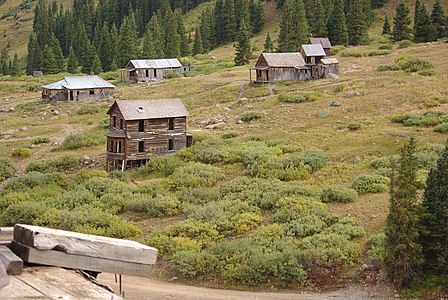
| Animas Forks[g] | San Juan | 37°55′52″N 107°34′17″W / 37.9311°N 107.5714°W / 37.9311; -107.5714 (Animas Forks) | 11,185 ft 3409 m | 1873[c] | 1915[b] | Silver mining town | Some structures remain. | |
| Antero Junction | Park | 38°55′24″N 105°57′55″W / 38.9233°N 105.9653°W / 38.9233; -105.9653 (Antero Junction) | 9,187 ft 2800 m | 1892[c] | Ranching town | Some structures remain. | ||
| Apex | Gilpin | 39°51′56″N 105°34′13″W / 39.8656°N 105.5702°W / 39.8656; -105.5702 (Apex) | 9,846 ft 3001 m | 1894[a] | 1932[b] | Gold mining town | Some structures remain. | |
| Arapahoe City[h] | Arapahoe | Jefferson | 39°46′30″N 105°10′42″W / 39.7750°N 105.1783°W / 39.7750; -105.1783 (Arapahoe) | 5,585 ft 1702 m | 1858[c] | 1867[d] | Placer gold camp | Historical marker near Golden |
| Arastra[i] | Arrastra, Silver Lake | San Juan | 37°47′34″N 107°36′25″W / 37.7928°N 107.6070°W / 37.7928; -107.6070 (Arastra) | 12,230 ft 3728 m | 1890[c] | 1919[b] | Mining town[5] | |
| Arrow | Grand | 1905[a] | 1915[b] | Railroad town | Little remains. | |||
| Ashcroft | Castle Forks City, Chloride | Pitkin | 39°03′13″N 106°47′59″W / 39.0536°N 106.7998°W / 39.0536; -106.7998 (Ashcroft) | 9,521 ft 2902 m | 1880[c] | 1912[b] | Silver mining town | National Register Historic Place |
| Auraria[j] | Denver | 39°44′34″N 105°00′19″W / 39.7428°N 105.0052°W / 39.7428; -105.0052 (Auraria) | 5,206 ft 1587 m | 1858[k] | 1859[l] | Placer gold camp | Historical park and Denver neighborhood | |
| Autobees Plaza[m] | Autobees | Pueblo | 38°12′36″N 104°17′14″W / 38.2100°N 104.2872°W / 38.2100; -104.2872 (Autobees) | 4,494 ft 1370 m | 1853[c] | 1882[d] | Farming village | Little remains. |
| Axial | Moffat | 40°17′07″N 107°47′31″W / 40.2853°N 107.7920°W / 40.2853; -107.7920 (Axial) | 6,454 ft 1967 m | 1883[a] | 1958[b] | Coal mining town | ||
| Bachelor | Teller, Bachelor City | Mineral | 1892[a] | 1912[b] | Silver mining town | Little remains. | ||
| Badito[n] | Little Orphan | Huerfano | 37°43′38″N 105°00′51″W / 37.7272°N 105.0142°W / 37.7272; -105.0142 (Badito) | 6,431 ft 1960 m | 1865[a] | 1910[b] | Ranching town and trail stop | Ruins remain. |
| Bakerville | Clear Creek | 39°41′29″N 105°48′18″W / 39.6914°N 105.8050°W / 39.6914; -105.8050 (Bakerville) | 9,787 ft 2983 m | 1865[c] | Silver camp | Foundations remain. | ||
| Baldwin | Gunnison | 38°45′50″N 107°02′52″W / 38.7639°N 107.0478°W / 38.7639; -107.0478 (Baldwin) | 8,767 ft 2672 m | 1909[a] | 1948[b] | Coal mining town | Some structures remain. | |
| Balzac | Morgan | 40°24′25″N 103°28′17″W / 40.4069°N 103.4713°W / 40.4069; -103.4713 (Balzac) | 4,105 ft 1251 m | Farming town | ||||
| Belden | Eagle | 39°31′32″N 106°23′10″W / 39.5255°N 106.3861°W / 39.5255; -106.3861 (Belden) | 9,646 ft 2940 m | Mining town | Little remains. | |||
| Bent's Fort | Bent's Old Fort | Otero | 38°02′26″N 103°25′46″W / 38.0406°N 103.4294°W / 38.0406; -103.4294 (Bent's Old Fort) | 4,005 ft 1221 m | 1833[o] | 1849[p] | Trading post | National Historic Site |
| Berwind | Las Animas | 37°18′30″N 104°37′06″W / 37.3084°N 104.6183°W / 37.3084; -104.6183 (Berwind) | 6,541 ft 1994 m | 1888[c] | 1931[b] | Coal company town | Many structures remain. | |
| Beshoar | Las Animas | 37°13′05″N 104°24′24″W / 37.2181°N 104.4066°W / 37.2181; -104.4066 (Beshoar) | 5,922 ft 1805 m | 1901[a] | 1903[b] | Farming town | ||
| Bijou Basin | El Paso | 39°08′08″N 104°27′25″W / 39.1356°N 104.4569°W / 39.1356; -104.4569 (Bijou Basin) | 6,398 ft 1950 m | 1869[a] | 1907[b] | Ranching town and railroad station | Little remains | |
| Bloom | Iron Spring | Otero | 37°41′15″N 103°57′24″W / 37.6875°N 103.9566°W / 37.6875; -103.9566 (Bloom) | 4,800 ft 1463 m | 1899[a] | 1938[b] | Farming town | |
| Boggsville[q] | Bent | 38°02′30″N 103°12′46″W / 38.0417°N 103.2127°W / 38.0417; -103.2127 (Boggsville) | 3,914 ft 1193 m | 1866[c] | 1975[d] | Stage stop and farming town | National Register Historic District | |
| Bonanza[r] | Bonanza City | Saguache | 38°17′41″N 106°08′32″W / 38.2947°N 106.1422°W / 38.2947; -106.1422 (Town of Bonanza) | 9,479 ft 2889 m | 1880[a] | 1938[b] | Silver mining town | Town government reactivated |
| Boston | Baca | 37°15′49″N 102°22′39″W / 37.2636°N 102.3776°W / 37.2636; -102.3776 (Boston) | 4,072 ft 1241 m | 1887[a] | 1893[b] | Ranching town[6] | Some structures remain. | |
| Bowen | Aylmer | Las Animas | 1900[a] | 1929[b] | Coal mining town | |||
| Bowerman | Gunnison | 1903[a] | 1910[b] | Gold mining town | Some structures remain. | |||
| Brodhead | Las Animas | 37°24′39″N 104°40′35″W / 37.4108°N 104.6764°W / 37.4108; -104.6764 (Brodhead) | 6,519 ft 1987 m | 1902[a] | 1939[b] | Coal mining town | Little remains | |
| Buckingham | Weld | 40°37′17″N 103°58′40″W / 40.6214°N 103.9777°W / 40.6214; -103.9777 (Buckingham) | 4,944 ft 1507 m | 1888[a] | 1966[b] | Ranching town | Some structures remain. | |
| Buckskin Joe[s] | Laurette, Buckskin | Park | 38°28′35″N 105°19′37″W / 38.4764°N 105.3269°W / 38.4764; -105.3269 (Buckskin Joe) | 10,761 ft 3280 m | 1861[a] | 1873[b] | Gold camp | Buildings removed |
| Buick | Beuck | Elbert | 1916[a] | 1925[b] | Railroad town | |||
| Caddoa | Bent | 38°02′52″N 102°57′58″W / 38.0478°N 102.9660°W / 38.0478; -102.9660 (Caddoa) | 3,881 ft 1183 m | 1881[a] | 1958[b] | Farming town | Some structures remain. | |
| Calcite | Fremont | 38°26′10″N 105°53′14″W / 38.4361°N 105.8872°W / 38.4361; -105.8872 (Calcite) | 7,601 ft 2317 m | 1903[c] | 1930[b] | Coal company town[7][8] | Some structures remain. | |
| California Ranch[t][u] | Franktown | Douglas | 39°23′21″N 104°45′09″W / 39.3892°N 104.7526°W / 39.3892; -104.7526 (California Ranch) | 6,139 ft 1871 m | 1861[c] | 1874[v] | Stage stop | Historic marker at Franktown |
| Calumet | Huerfano | 37°41′34″N 104°51′35″W / 37.6928°N 104.8597°W / 37.6928; -104.8597 (Calumet) | 6,391 ft 1948 m | 1904[c] | Coal mining town | Structures remain. | ||
| Cameo | Mesa | 39°08′55″N 108°19′15″W / 39.1486°N 108.3209°W / 39.1486; -108.3209 (Cameo) | 4,787 ft 1459 m | 1907[a] | 1969[b] | Coal mining town | Little remains. | |
| Camp Hale | Eagle | 39°26′35″N 106°19′22″W / 39.4430°N 106.3228°W / 39.4430; -106.3228 (Camp Hale) | 9,238 ft 2816 m | 1942[w] | 1945[x] | U.S. Army mountain training camp | National Monument | |
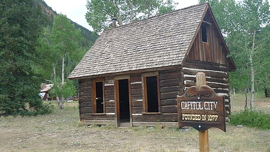
| Capitol City | Galena City | Hinsdale | 38°00′26″N 107°28′00″W / 38.0072°N 107.4667°W / 38.0072; -107.4667 (Capitol City) | 9,711 ft 2960 m | 1877[a] | 1920[b] | Silver mining town | Structures remain. |
| Carbonate[y][z] | Garfield | 39°44′35″N 107°20′48″W / 39.7430°N 107.3467°W / 39.7430; -107.3467 (Town of Carbonate) | 10,926 ft 3330 m | 1879[c] | 1886[b] | Silver camp | Town government reactivated | |
| Caribou[aa] | Boulder | 39°58′51″N 105°34′43″W / 39.9808°N 105.5786°W / 39.9808; -105.5786 (Caribou) | 9,971 ft 3039 m | 1871[a] | 1917[b] | Silver mining town | Some structures remain. | |
| Carpenter | Mesa | 39°11′40″N 108°28′24″W / 39.1944°N 108.4733°W / 39.1944; -108.4733 (Carpenter) | 5,808 ft 1770 m | 1890[a] | 1925[d] | Coal mining town | Little remains. | |
| Carrizo | Carriso | Baca | 1887[a] | 1916[b] | Ranching town | |||
| Carson[ab] | Hinsdale | 37°52′09″N 107°21′44″W / 37.8691°N 107.3623°W / 37.8691; -107.3623 (Carson) | 11,574 ft 3528 m | 1889[a] | 1903[b] | Mining town | Many structures remain. | |
| Chandler | Fremont | 38°22′23″N 105°12′02″W / 38.3731°N 105.2005°W / 38.3731; -105.2005 (Chandler) | 5,738 ft 1749 m | 1890[a] | 1942[b] | Coal company town | ||
| Chattanooga | San Juan | 37°52′25″N 107°43′31″W / 37.8736°N 107.7253°W / 37.8736; -107.7253 (Chattanooga) | 10,263 ft 3128 m | 1883[a] | 1894[b] | Mining camp | Some structures remain. | |
| Chihuahua | Summit | 1880[a] | 1892[b] | Mining camp | ||||
| Chivington[ac] | Kiowa | 38°26′11″N 102°32′37″W / 38.4364°N 102.5435°W / 38.4364; -102.5435 (Chivington) | 3,891 ft 1186 m | 1887[a] | 1991[b] | Ranching town | Many structures remain. | |
| Clarkville | Yuma | 40°23′42″N 102°37′34″W / 40.3950°N 102.6260°W / 40.3950; -102.6260 (Clarkville) | 4,016 ft 1224 m | 1933[c] | 1954[b] | Farming town | ||
| Climax[ad][ae] | Lake | 39°22′08″N 106°11′01″W / 39.3689°N 106.1836°W / 39.3689; -106.1836 (Climax) | 11,342 ft 3457 m | 1887[a] | 1962[af] | Railroad and mining town | Removed for Climax molybdenum mine | |
| Coalmont | Jackson | 40°33′45″N 106°26′40″W / 40.5625°N 106.4445°W / 40.5625; -106.4445 (Coalmont) | 8,216 ft 2504 m | 1911[c] | 1983[b] | Coal mining town | Structures remain. | |
| Colfax | Custer | 1870[a] | 1879[b] | Communal farming town | ||||
| Columbine | Routt | 40°51′15″N 106°57′57″W / 40.8541°N 106.9659°W / 40.8541; -106.9659 (Columbine) | 8,701 ft 2652 m | 1896[a] | 1867[b] | Gold mining town | National Register Historic District | |
| Corona[ag] | Grand | 39°56′04″N 105°41′07″W / 39.9344°N 105.6853°W / 39.9344; -105.6853 (Corona) | 11,723 ft 3573 m | 1904[c] | 1928[d] | Railroad station with snowshed and hotel | Foundations remain. | |
| Cross Mountain | Moffat | 1919[a] | 1943[b] | |||||
| Crystal | Crystal City | Gunnison | 39°03′33″N 107°06′04″W / 39.0592°N 107.1012°W / 39.0592; -107.1012 (Crystal) | 8,951 ft 2728 m | 1881[c] | 1917[d] | Mining town | Structures remain. |
| Dakan | Douglas | 1896[a] | 1898[b] | Mining camp | Nothing remains. | |||
| Dallas | Dallas City | Ouray | 38°11′00″N 107°44′41″W / 38.1833°N 107.7448°W / 38.1833; -107.7448 (Dallas) | 6,923 ft 2110 m | 1880[c] | 1899[b] | Stage stop and railroad station | Little remains. |
| Dayton[ah][ai] | Lake | 39°04′58″N 106°22′55″W / 39.0828°N 106.3820°W / 39.0828; -106.3820 (Dayton) | 9,232 ft 2814 m | 1866[a] | 1868[b] | Gold camp | Site in Twin Lakes CDP | |
| Dearfield[aj] | Weld | 40°17′26″N 104°15′34″W / 40.2905°N 104.2594°W / 40.2905; -104.2594 (Dearfield) | 4,498 ft 1371 m | 1910[ak] | 1948[al] | African American farming community | National Register Historic District | |
| Decatur | Summit | 1879[a] | 1885[b] | Mining camp | ||||
| Delagua | Las Animas | 37°20′24″N 104°39′47″W / 37.3400°N 104.6630°W / 37.3400; -104.6630 (Delagua) | 6,686 ft 2038 m | 1903[a] | 1954[b] | Coal company town | ||
| Delcarbon | Huerfano | 37°42′45″N 104°52′37″W / 37.7125°N 104.8769°W / 37.7125; -104.8769 (Delcarbon) | 6,342 ft 1933 m | 1915[a] | 1953[b] | Coal mining town | ||
| Dick | Weld | 40°01′53″N 104°56′14″W / 40.0314°N 104.9372°W / 40.0314; -104.9372 (Dick) | 5,128 ft 1563 m | 1870[c] | 1979[d] | Railroad and coal mining town | ||
| Duncan | Saguache | 37°52′27″N 105°36′52″W / 37.8742°N 105.6145°W / 37.8742; -105.6145 (Duncan) | 8,107 ft 2471 m | 1874[c] | 1900[b] | Gold camp | Duncan Cabin preserved | |
| Dutchtown | Grand | 40°26′16″N 105°52′54″W / 40.4378°N 105.8817°W / 40.4378; -105.8817 (Dutchtown) | 10,755 ft 3278 m | 1879[c] | 1884[d] | Silver camp | Site in Rocky Mountain National Park | |
| Dyersville | Summit | 39°25′14″N 105°59′02″W / 39.4205°N 105.9839°W / 39.4205; -105.9839 (Dyersville) | 10,880 ft 3316 m | 1881[c] | 1908[d] | Mining town | Some frames remain. | |
| Eastdale | Costilla | 37°01′43″N 105°39′03″W / 37.0286°N 105.6508°W / 37.0286; -105.6508 (Eastdale) | 7,533 ft 2296 m | 1890[ak] | 1909[b] | Farming town | ||
| Eastonville | Easton | El Paso | 39°03′40″N 104°33′44″W / 39.0611°N 104.5622°W / 39.0611; -104.5622 (Eastonville) | 7,235 ft 2205 m | 1872[a] | 1932[b] | Railroad and farming town | Some structures remain. |
| Edgerton | El Paso | 38°57′38″N 104°50′09″W / 38.9606°N 104.8359°W / 38.9606; -104.8359 (Edgerton) | 6,398 ft 1950 m | 1870[a] | 1902[b] | Railroad town | ||
| Eldora[am] | Happy Valley, El Dorado | Boulder | 39°56′55″N 105°33′50″W / 39.9486°N 105.5639°W / 39.9486; -105.5639 (Eldora CDP) | 8,642 ft 2634 m | 1897[a] | 1977[b] | Mining town | National Register Historic District |
| Elkton | Gunnison | 38°57′49″N 107°02′00″W / 38.9636°N 107.0334°W / 38.9636; -107.0334 (Elkton) | 10,453 ft 3186 m | 1881[a] | 1882[b] | Mining camp | Many structures remain. | |
| Elkton | Teller | 38°43′20″N 105°09′02″W / 38.7222°N 105.1505°W / 38.7222; -105.1505 (Elkton) | 9,971 ft 3039 m | 1895[a] | 1926[b] | Gold mining town | Some structures remain. | |
| Eureka | San Juan | 37°52′47″N 107°33′54″W / 37.8797°N 107.5651°W / 37.8797; -107.5651 (Eureka) | 9,863 ft 3006 m | 1873[c] | 1942[b] | Gold mining town | Some structures remain. | |
| Floresta | Gunnison | 38°50′31″N 107°07′22″W / 38.8419°N 107.1228°W / 38.8419; -107.1228 (Floresta) | 9,879 ft 3011 m | 1897[a] | 1919[b] | Coal mining town | Little remains. | |
| Fondis | Elbert | 39°12′57″N 104°20′50″W / 39.2158°N 104.3472°W / 39.2158; -104.3472 (Fondis) | 6,175 ft 1882 m | 1895[a] | 1954[b] | Ranching town | ||
| Franceville | El Paso | 38°48′24″N 104°35′41″W / 38.8066°N 104.5948°W / 38.8066; -104.5948 (Franceville) | 6,077 ft 1852 m | 1881[a] | 1894[b] | Coal mining town | ||
| Frankstown[t] | Douglas | 39°25′58″N 104°45′41″W / 39.4327°N 104.7614°W / 39.4327; -104.7614 (Frankstown) | 6,060 ft 1847 m | 1859[c] | 1864[b] | Placer gold camp | Nothing remains. | |
| Fulford[an] | Eagle | 39°30′54″N 106°39′23″W / 39.5150°N 106.6564°W / 39.5150; -106.6564 (Fulford CDP) | 9,840 ft 2999 m | 1892[a] | 1910[b] | Mining camp | Structures remain. | |
| Garo | Park | 39°06′28″N 105°53′25″W / 39.1078°N 105.8903°W / 39.1078; -105.8903 (Garo) | 9,197 ft 2803 m | 1880[a] | 1955[b] | Ranching town | Some structures remain. | |
| Gato | Archuleta | 37°02′42″N 107°11′50″W / 37.0450°N 107.1973°W / 37.0450; -107.1973 (Gato, Colorado) | 6,302 ft 1921 m | 1899[c] | 1954[d] | Ranching town | ||
| Geneva City | Clear Creek | 39°34′26″N 105°48′48″W / 39.5739°N 105.8132°W / 39.5739; -105.8132 (Geneva City) | 11,585 ft 3531 m | Mining camp | Some structures remain. | |||
| Gillett | West Beaver Park, Cripple City, Gillette | Teller | 38°46′55″N 105°07′22″W / 38.7819°N 105.1228°W / 38.7819; -105.1228 (Gillett) | 9,938 ft 3029 m | 1894[a] | 1913[b] | Gold mining town | Little remains. |
| Gilman | Eagle | 39°31′58″N 106°23′38″W / 39.5328°N 106.3939°W / 39.5328; -106.3939 (Gilman) | 8,951 ft 2728 m | 1886[a] | 1985[b] | Mining company town | Company town largely intact | |
| Gold Park | Eagle | 39°24′05″N 106°26′22″W / 39.4014°N 106.4394°W / 39.4014; -106.4394 (Gold Park) | 9,268 ft 2825 m | 1881[a] | 1983[b] | Gold mining town | ||
| Goldfield[ao] | Teller | 38°43′04″N 105°07′34″W / 38.7178°N 105.1261°W / 38.7178; -105.1261 (Goldfield CDP) | 9,902 ft 3018 m | 1895[a] | 1932[b] | Gold mining town | Many structures remain. | |
| Gothic | Gunnison | 38°57′33″N 106°59′23″W / 38.9592°N 106.9898°W / 38.9592; -106.9898 (Gothic) | 9,485 ft 2891 m | 1879[a] | 1914[b] | Silver mining town[ap] | Rocky Mountain Biological Laboratory | |
| Graysill Mines | San Juan | 37°42′46″N 107°53′55″W / 37.7128°N 107.8986°W / 37.7128; -107.8986 (Graysill Mines) | 10,951 ft 3338 m | 1945[c] | 1963[d] | Uranium mining town | Structures remain. | |
| Guston | Ouray | 37°54′59″N 107°41′25″W / 37.9164°N 107.6903°W / 37.9164; -107.6903 (Guston) | 10,847 ft 3306 m | 1883[c] | 1898[b] | Silver mining town | Structures remain. | |
| Gwillimsville | El Paso | 1878[a] | 1890[b] | Ranching town | ||||
| Hamilton | Park | 1860[a] | 1881[b] | Placer gold camp | Little remains. | |||
| Hancock | Chaffee | 38°38′23″N 106°21′39″W / 38.6397°N 106.3608°W / 38.6397; -106.3608 (Hancock) | 11,054 ft 3369 m | 1880[a] | 1904[b] | Railroad and mining town | Little remains. | |
| Haybro | Junction City | Routt | 40°19′56″N 106°57′34″W / 40.3322°N 106.9595°W / 40.3322; -106.9595 (Haybro) | 7,297 ft 2224 m | 1912[a] | 1951[b] | Coal mining town | Little remains. |
| Henderson Island | Island Station | Adams | 39°55′48″N 104°52′07″W / 39.9300°N 104.8687°W / 39.9300; -104.8687 (Henderson Island) | 5,010 ft 1527 m | 1859[a] | 1959[d] | Trail stop | Adams County Fairgrounds |
| Henson | Hinsdale | 38°01′15″N 107°22′37″W / 38.0208°N 107.3770°W / 38.0208; -107.3770 (Henson) | 9,236 ft 2815 m | 1871[c] | 1913[b] | Gold mining town | Structures remain. | |
| Highland[aq] | Denver | 39°45′37″N 105°00′33″W / 39.7603°N 105.0092°W / 39.7603; -105.0092 (Highland) | 5,236 ft 1596 m | 1858[ar] | 1859[l] | Placer gold camp | Denver neighborhood | |
| Holy Cross City[as] | Holy Cross | Eagle | 39°24′54″N 106°28′41″W / 39.4150°N 106.4781°W / 39.4150; -106.4781 (Holy Cross City) | 11,428 ft 3483 m | 1880[c] | 1905[b] | Mining town | Few structures remain. |
| Homestead Meadows | Larimer | 40°18′55″N 105°27′23″W / 40.3154°N 105.4565°W / 40.3154; -105.4565 (Homestead Meadows) | 8,690 ft 2649 m | 1889[c] | 1952[d] | Ranch and logging community | National Register Historic District | |
| Howardsville[at] | Bullion City | San Juan | 37°50′08″N 107°35′39″W / 37.8356°N 107.5942°W / 37.8356; -107.5942 (Howardsville) | 9,748 ft 2971 m | 1874[c] | 1939[b] | Gold mining town | Modern mill |
| Howbert | Park | 1887[a] | 1933[b] | Railroad and ranching town | Submerged in Eleven Mile Reservoir | |||
| Husted | El Paso | 1878[a] | 1920[b] | Railroad and ranching town | Site in U.S. Air Force Academy | |||
| Independence | Farwell, Sparkill, Chipeta | Pitkin | 39°06′26″N 106°36′21″W / 39.1072°N 106.6059°W / 39.1072; -106.6059 (Independence) | 10,913 ft 3326 m | 1879[c] | 1899[b] | Gold camp | National Register Historic District |
| Independence | Macon | Teller | 38°43′56″N 105°08′12″W / 38.7322°N 105.1366°W / 38.7322; -105.1366 (Independence) | 10,640 ft 3243 m | 1899[a] | 1954[b] | Gold mining town | Little remains. |
| Iola | Gunnison | 38°28′30″N 107°05′50″W / 38.4750°N 107.0973°W / 38.4750; -107.0973 (Iola) | 7,523 ft 2293 m | 1896[a] | 1963[b] | Railroad town | Submerged in Blue Mesa Reservoir | |
| Ironton | Ouray | 37°55′58″N 107°40′49″W / 37.9328°N 107.6803°W / 37.9328; -107.6803 (Ironton, Colorado) | 9,800 ft 2987 m | 1883[a] | 1920[b] | Silver mining town | Some structures remain. | |
| Jimmy's Camp | Jimmy Camp | El Paso | 1833[c] | 1879[b] | Trading post and stage stop | Nothing remains. | ||
| Juanita | Archuleta | 37°01′38″N 107°09′02″W / 37.0272°N 107.1506°W / 37.0272; -107.1506 (Juanita) | 6,375 ft 1943 m | 1904[a] | 1912[b] | Railroad and ranching town | Railroad structures remain. | |
| Keota | Weld | 40°42′10″N 104°04′31″W / 40.7028°N 104.0752°W / 40.7028; -104.0752 (Keota) | 4,964 ft 1513 m | 1888[a] | 1973[b] | Railroad and ranching town | Structures remain. | |
| Kings Canyon | Jackson | 40°55′37″N 106°13′37″W / 40.9269°N 106.2270°W / 40.9269; -106.2270 (Kings Canyon) | 8,396 ft 2559 m | 1928[a] | 1936[b] | Copper mining town | Little remains. | |
| Kokomo | Summit | 39°25′27″N 106°11′23″W / 39.4242°N 106.1897°W / 39.4242; -106.1897 (Kokomo) | 10,696 ft 3260 m | 1879[a] | 1965[b] | Mining town | Buried under mine waste | |
| La Veta Pass | Veta Pass, Uptop | Huerfano | 37°35′35″N 105°12′12″W / 37.5931°N 105.2033°W / 37.5931; -105.2033 (La Veta Pass, Colorado) | 9,390 ft 2862 m | 1877[c] | 1962[d] | Railroad and tourism town | National Register Historic District |
| Last Chance | Washington | 39°44′27″N 103°35′30″W / 39.7408°N 103.5916°W / 39.7408; -103.5916 (Last Chance) | 4,820 ft 1469 m | 1925[c] | Farming town and highway stop | Structures remain. | ||
| Lenado | Pitkin | 39°14′33″N 106°45′45″W / 39.2425°N 106.7625°W / 39.2425; -106.7625 (Lenado) | 8,540 ft 2603 m | 1891[a] | 1907[b] | Mining town | Some structures remain. | |
| Liberty | Saguache | 37°51′37″N 105°35′45″W / 37.8603°N 105.5958°W / 37.8603; -105.5958 (Liberty) | 8,275 ft 2522 m | 1900[a] | 1921[b] | Gold mining town | ||
| Ludlow[au] | Las Animas | 37°20′00″N 104°35′00″W / 37.3333°N 104.5833°W / 37.3333; -104.5833 (Ludlow) | 6,283 ft 1915 m | 1896[a] | 1954[b] | Coal mining town | National Historic Landmark | |
| Lulu City | Grand | 40°26′44″N 105°50′53″W / 40.4455°N 105.8481°W / 40.4455; -105.8481 (Lulu City) | 9,350 ft 2850 m | 1879[c] | 1951[d] | Silver camp | Three cabins remain. | |
| Lytle | Turkey Creek | El Paso | 38°36′07″N 104°52′01″W / 38.6019°N 104.8669°W / 38.6019; -104.8669 (Lytle) | 6,250 ft 1905 m | 1877[a] | 1920[b] | Farming town | Schoolhouse remains. |
| Madrid | Madrid Plaza | Las Animas | 37°07′39″N 104°38′29″W / 37.1276°N 104.6413°W / 37.1276; -104.6413 (Madrid) | 6,286 ft 1916 m | 1864[c] | 1917[b] | Farming town | |
| Malachite | Huerfano | 37°45′16″N 105°15′39″W / 37.7544°N 105.2608°W / 37.7544; -105.2608 (Malachite) | 7,491 ft 2283 m | 1880[a] | 1915[b] | Placer gold camp | ||
| Malta | Lake | 39°13′46″N 106°21′03″W / 39.2294°N 106.3509°W / 39.2294; -106.3509 (Malta) | 9,590 ft 2923 m | 1875[a] | 1955[b] | Silver mining town | Schoolhouse remains. | |
| Manhattan | Larimer | 40°43′56″N 105°36′00″W / 40.7322°N 105.6000°W / 40.7322; -105.6000 (Manhattan) | 8,475 ft 2583 m | 1887[a] | 1900[b] | Gold camp | Cemetery remains. | |
| Masters | Weld | 40°18′34″N 104°14′42″W / 40.3094°N 104.2450°W / 40.3094; -104.2450 (Masters) | 4,456 ft 1358 m | 1900[a] | 1967[b] | Railroad and farming town | ||
| Mayday[av] | La Plata | 37°21′02″N 108°04′36″W / 37.3506°N 108.0767°W / 37.3506; -108.0767 (Mayday) | 8,734 ft 2662 m | 1913[a] | 1914[b] | Mining town | Structures remain. | |
| Mayflower Gulch | Summit | Mining town | Structures remain. | |||||
| McConnellsville | El Paso | Railroad station | ||||||
| McFerran | El Paso | 1889[a] | 1896[b] | Farming town | ||||
| McPhee | Montezuma | 1924[a] | 1948[b] | Logging company town | Submerged in McPhee Reservoir | |||
| Middleton | San Juan | 37°51′18″N 107°34′20″W / 37.8550°N 107.5723°W / 37.8550; -107.5723 (Middleton) | 9,794 ft 2985 m | 1883[c] | Gold mining town | Little remains. | ||
| Mineral Point | Weld | 1873[c] | 1897[b] | Mining camp | Some structures remain. | |||
| Missouri City | Missouri Flats | Gilpin | 39°47′24″N 105°30′26″W / 39.7901°N 105.5073°W / 39.7901; -105.5073 (Missouri City) | 8,870 ft 2704 m | 1860[a] | 1863[b] | Placer gold camp | A single grave remains. |
| Montana[aw] | Montana City | Denver | 39°40′36″N 104°59′42″W / 39.6767°N 104.9950°W / 39.6767; -104.9950 (Montana) | 5,210 ft 1588 m | 1858[c][ax] | 1859[b][ay] | Placer gold camp | Near Grant-Frontier Park in south Denver |
| Montezuma[az] | Summit | 39°34′52″N 105°52′02″W / 39.5811°N 105.8672°W / 39.5811; -105.8672 (Town of Montezuma) | 10,312 ft 3143 m | 1865[c] | Silver mining town | Town government reactivated | ||
| Montgomery | Montgomery City | Park | 1881[c] | 1888[b] | Gold camp | Submerged in Montgomery Reservoir | ||
| Morley | Las Animas | 37°01′55″N 104°30′17″W / 37.0320°N 104.5047°W / 37.0320; -104.5047 (Morley) | 7,027 ft 2142 m | 1878[c] | 1956[b] | Railroad and coal mining town | ||
| Mount Vernon[ba] | Jefferson | 39°41′37″N 105°12′23″W / 39.6935°N 105.2065°W / 39.6935; -105.2065 (Mount Vernon) | 6,340 ft 1932 m | 1859[c] | 1885[b] | Trail stop | Located in Matthews/Winters Park | |
| Mystic | Routt | 40°34′12″N 106°59′45″W / 40.5700°N 106.9959°W / 40.5700; -106.9959 (Mystic) | 6,900 ft 2103 m | 1910[a] | 1942[b] | Ranching town | Little remains. | |
| Needleton | San Juan | 37°38′26″N 107°41′29″W / 37.6406°N 107.6915°W / 37.6406; -107.6915 (Needleton) | 8,278 ft 2523 m | 1882[a] | 1910[b] | Railroad town | ||
| Nevadaville | Nevada, Nevada City, Bald Mountain | Gilpin | 39°47′43″N 105°31′57″W / 39.7953°N 105.5325°W / 39.7953; -105.5325 (Nevadaville) | 9,121 ft 2780 m | 1861[a] | 1921[b] | Mining town | Some residents remain. |
| Niegoldstown | San juan | 1878[a] | 1881[b] | Mining camp | Some structures remain. | |||
| Norrie[bb] | Norrie Colony | Pitkin | 39°19′29″N 106°39′20″W / 39.3247°N 106.6556°W / 39.3247; -106.6556 (Norrie CDP) | 8,462 ft 2579 m | Railroad and logging camp | Summer cabins | ||
| North Creede | Jimtown | Mineral | 37°51′51″N 106°55′33″W / 37.8642°N 106.9259°W / 37.8642; -106.9259 (North Creede) | 8,964 ft 2732 m | 1908[a] | 1919[b] | Silver mining town | Few structures remain. |
| North Star | Lake's Camp | Gunnison | 1889[a] | 1894[b] | Mining camp | Some structures remain. | ||
| Ohio | Ohio City | Gunnison | 38°34′00″N 106°36′42″W / 38.5667°N 106.6117°W / 38.5667; -106.6117 (Ohio) | 8,570 ft 2612 m | 1880[a] | 1972[b] | Mining town | Some residents |
| Old Roach | Larimer | 40°55′28″N 106°07′02″W / 40.9244°N 106.1172°W / 40.9244; -106.1172 (Old Roach) | 9,380 ft 2859 m | 1923[c] | 1938[d] | Logging company town | ||
| Old Zounds | O.Z. | El Paso | 1877[a] | 1889[b] | Ranching village | |||
| Orient | Saguache | 38°12′15″N 105°49′00″W / 38.2043°N 105.8168°W / 38.2043; -105.8168 (Orient) | 8,885 ft 2708 m | 1894[a] | 1905[b] | Iron mining town | Two adjacent townsites | |
| Oro City[bc][bd] | Oro | Lake | 39°14′07″N 106°15′08″W / 39.2353°N 106.2522°W / 39.2353; -106.2522 (Oro City) | 10,708 ft 3264 m | 1861[a] | 1895[b] | Gold camp | |
| Pagosa Junction | Archuleta | 37°02′17″N 107°11′57″W / 37.0381°N 107.1992°W / 37.0381; -107.1992 (Pagosa Junction, Colorado) | 6,266 ft 1910 m | 1899[a] | 1954[b] | Railroad town | Some structures remain. | |
| Pando | Eagle | 39°27′26″N 106°20′01″W / 39.4572°N 106.3336°W / 39.4572; -106.3336 (Pando) | 9,203 ft 2805 m | 1891[a] | 1942[b] | Railroad station | ||
| Pandora | San Miguel | 37°56′00″N 107°47′08″W / 37.9333°N 107.7856°W / 37.9333; -107.7856 (Pandora) | 8,954 ft 2729 m | 1881[a] | 1902[b] | Mining camp | Little remains. | |
| Parkville[be] | Park City | Summit | 39°29′56″N 106°57′00″W / 39.4989°N 106.9500°W / 39.4989; -106.9500 (Parkville) | 10,466 ft 3190 m | 1861[c] | 1866[b] | Gold camp | Cemetery remains. |
| Parrott City[bf][av] | Parrott | La Plata | 37°21′02″N 108°04′36″W / 37.3506°N 108.0767°W / 37.3506; -108.0767 (Parrott City) | 8,734 ft 2662 m | 1876[a] | 1898[b] | Mining camp | Remnants of Mayday |
| Pearl | Jackson | 40°59′07″N 106°32′49″W / 40.9852°N 106.5470°W / 40.9852; -106.5470 (Pearl) | 8,406 ft 2562 m | 1889[a] | 1919[b] | Copper mining town | Many structures remain. | |
| Pieplant Mill | Pieplant | Gunnison | 38°56′17″N 106°33′34″W / 38.9380°N 106.5595°W / 38.9380; -106.5595 (Pieplant Mill) | 10,309 ft 3142 m | 1904[a] | 1906[b] | Mining town | |
| Pinneo | Washington | 40°12′34″N 103°26′19″W / 40.2094°N 103.4386°W / 40.2094; -103.4386 (Pinneo) | 4,364 ft 1330 m | 1883[a] | 1931[b] | Farming town | ||
| Pittsburg | Gunnison | 38°57′08″N 107°03′45″W / 38.9522°N 107.0625°W / 38.9522; -107.0625 (Pittsburg) | 9,279 ft 2828 m | 1881[a] | 1896[b] | Mining town | Little remains. | |
| Platte Station | Platte | Park | 1876[a] | 1894[b] | Stage stop | |||
| Poudre City | Larimer | 40°41′53″N 105°37′24″W / 40.6980°N 105.6233°W / 40.6980; -105.6233 (Poudre City) | 7,332 ft 2235 m | 1888[c] | 1891[bg] | Gold mill town | Nothing remains. | |
| Preston | Summit | 39°29′45″N 106°01′16″W / 39.4958°N 106.0211°W / 39.4958; -106.0211 (Preston) | 10,731 ft 3271 m | 1875[a] | 1889[b] | Gold camp | ||
| Primero | Las Animas | 37°08′33″N 104°44′30″W / 37.1425°N 104.7417°W / 37.1425; -104.7417 (Primero) | 6,815 ft 2077 m | 1901[a] | 1933[b] | Coal company town | ||
| Proctor | Logan | 40°48′25″N 102°57′06″W / 40.8069°N 102.9516°W / 40.8069; -102.9516 (Proctor) | 3,780 ft 1152 m | 1908[a] | 1963[b] | Railroad and farming town | Some structures remain. | |
| Purcell | Weld | 40°38′18″N 104°36′06″W / 40.6383°N 104.6016°W / 40.6383; -104.6016 (Purcell) | 5,023 ft 1531 m | 1909[c] | 1951[b] | Farming town | Some structures remain. | |
| Quartz | Gunnison | 1882[a] | 1886[b] | Gold camp | Historical marker | |||
| Querida | Bassickville Bassick City | Custer | 38°07′34″N 105°20′04″W / 38.1261°N 105.3344°W / 38.1261; -105.3344 (Querida) | 8,987 ft 2739 m | 1880[a] | 1906[b] | Silver mining town | |
| Red Mountain | Red Mountain Town | Ouray | 37°54′13″N 107°42′09″W / 37.9036°N 107.7026°W / 37.9036; -107.7026 (Red Mountain) | 10,935 ft 3333 m | 1883[a] | 1913[b] | Silver mining town | Few original structures |
| Rexford[bh] | Summit | 39°32′02″N 105°53′45″W / 39.5339°N 105.8958°W / 39.5339; -105.8958 (Rexford) | 11,431 ft 3484 m | 1881[c] | 1883[b] | Gold camp | Structures remain. | |
| Robinson | Ten Mile | Summit | 1879[a] | 1911[b] | Mining town | |||
| Romley | Chaffee | 38°40′30″N 106°22′12″W / 38.6750°N 106.3700°W / 38.6750; -106.3700 (Romley) | 10,319 ft 3145 m | 1886[a] | 1924[b] | Railroad and mining town | Little remains. | |
| Roses Cabin | Hinsdale | 1874[c] | 1887[b] | Mining camp | Little remains. | |||
| Rosita | Custer | 38°05′50″N 105°20′10″W / 38.0972°N 105.3361°W / 38.0972; -105.3361 (Rosita) | 8,809 ft 2685 m | 1874[a] | 1966[b] | Ranching and silver mining town | One business open | |
| Ruby | Lincoln Creek | Pitkin | 39°01′15″N 106°36′33″W / 39.0208°N 106.6092°W / 39.0208; -106.6092 (Ruby) | 11,382 ft 3469 m | Mining camp | Some structures remain. | ||
| Ruby City | Ouray | 1878[a] | 1879[b] | Mining camp | Some structures remain. | |||
| Russell Gulch | Gilpin | 39°46′43″N 105°32′13″W / 39.7786°N 105.5369°W / 39.7786; -105.5369 (Russell Gulch) | 9,147 ft 2788 m | 1859[c] | 1943[b] | Placer gold camp | Some residents remain. | |
| Russellville | Douglas | 1862[c] | 1862[b] | Placer gold camp | Later structures remain. | |||
| St. Charles[bi] | Denver | 39°45′12″N 105°00′11″W / 39.7533°N 105.0031°W / 39.7533; -105.0031 (St. Charles) | 5,184 ft 1580 m | 1858[bj] | 1858[bk] | Placer gold camp | Site around Denver Union Station | |
| Saint Elmo | Chaffee | 38°42′17″N 106°20′53″W / 38.7047°N 106.3481°W / 38.7047; -106.3481 (Saint Elmo) | 10,007 ft 3050 m | 1880[c] | 1952[b] | Railroad and mining town | National Register Historic District | |
| Saint Vrain[bl] | Weld | 40°16′37″N 104°51′10″W / 40.2770°N 104.8527°W / 40.2770; -104.8527 (St. Vrain) | 4,762 ft 1451 m | 1837[c] | 1875[b] | Trading village | Adjacent to site of Fort Saint Vrain | |
| Saint Vrains | Weld | 40°02′13″N 104°57′17″W / 40.0369°N 104.9547°W / 40.0369; -104.9547 (Saint Vrains) | 5,109 ft 1557 m | 1915[a] | 1918[b] | Farming town | ||
| Saints John | Coleyville, Saint John | Summit | 39°34′18″N 105°52′54″W / 39.5717°N 105.8817°W / 39.5717; -105.8817 (Saints John) | 10,765 ft 3281 m | 1863[c] | 1881[b] | Silver camp | Some residents remain. |
| San Juan City[bm] | San Juan | Mineral[bn] | 37°47′09″N 107°08′39″W / 37.7857°N 107.1441°W / 37.7857; -107.1441 (San Juan City) | 9,028 ft 2752 m | 1874[a] | 1923[b] | Stage stop | One cabin remains. |
| Schofield | Gunnison | 1880[a] | 1886[b] | Mining camp | Little remains. | |||
| Sellar | Pitkin | 1888[a] | 1918[b] | Stage stop | Structures remain. | |||
| Serene[bo] | Weld | 40°01′27″N 105°01′33″W / 40.0242°N 105.0259°W / 40.0242; -105.0259 (Serene) | 5,185 ft 1580 m | 1923[a] | 1942[b] | Coal company town | ||
| Seven Lakes | Teller | 38°46′54″N 105°00′31″W / 38.7817°N 105.0086°W / 38.7817; -105.0086 (Seven Lakes) | 10,985 ft 3348 m | 1877[c] | Mining and tourist town | Mine structures remain. | ||
| Sherman | Hinsdale | 1890[a] | 1892[b] | Mining camp | Some structures remain. | |||
| Sherrod | Gunnison | 1904[a] | 1906[b] | Mining camp | Little remains. | |||
| Siloam | Pueblo | 38°15′05″N 104°58′33″W / 38.2514°N 104.9758°W / 38.2514; -104.9758 (Siloam) | 5,450 ft 1661 m | 1891[a] | 1943[b] | Farming town | Little remains. | |
| Silver Creek | Daileyville | Clear Creek | 39°45′13″N 105°37′56″W / 39.7536°N 105.6322°W / 39.7536; -105.6322 (Silver Creek) | 9,120 ft 2780 m | 1875[c] | Silver camp | ||
| Silverdale | Clear Creek | 39°41′30″N 105°41′46″W / 39.6917°N 105.6961°W / 39.6917; -105.6961 (Silverdale) | 9,275 ft 2827 m | 1882[a] | 1882[b] | Silver camp | ||
| Sligo | Weeld | 1908[a] | 1941[b] | Railroad town | ||||
| Smuggler | San Miguel | 1895[a] | 1928[b] | Mining camp | Structures remain. | |||
| Sneffels | Mount Sneffels | Ouray | 37°58′31″N 107°44′59″W / 37.9753°N 107.7498°W / 37.9753; -107.7498 (Sneffels) | 10,621 ft 3237 m | 1879[a] | 1930[b] | Mining camp | |
| Sopris | Las Animas | 37°08′05″N 104°33′52″W / 37.1347°N 104.5644°W / 37.1347; -104.5644 (Sopris) | 6,234 ft 1900 m | 1888[a] | 1969[b] | Coal mining town | Submerged in Trinidad Lake | |
| South Denver[bp] | Denver | 39°40′43″N 104°58′10″W / 39.6786°N 104.9694°W / 39.6786; -104.9694 (South Denver) | 5,344 ft 1629 m | 1886[c] | 1894[bq] | Residential community | Several Denver neighborhoods | |
| Spar City | Spar | Mineral | 37°42′26″N 106°58′06″W / 37.7072°N 106.9684°W / 37.7072; -106.9684 (Spar City) | 9,466 ft 2885 m | 1892[a] | 1895[b] | Silver mining town | Summer cabins |
| Stout | Petra | Larimer | 40°31′36″N 105°09′27″W / 40.5266°N 105.1576°W / 40.5266; -105.1576 (Stout) | 5,340 ft 1628 m | 1882[a] | 1908[b] | Sandstone quarry town | Submerged in Horsetooth Reservoir |
| Summitville[br] | Summit | Rio Grande | 37°25′50″N 106°35′32″W / 37.4306°N 106.5923°W / 37.4306; -106.5923 (Summitville) | 11,287 ft 3440 m | 1876[a] | 1947[b] | Gold mining town | Many structures remain. |
| Sunset | Boulder | 40°02′09″N 105°28′08″W / 40.0358°N 105.4689°W / 40.0358; -105.4689 (Sunset) | 7,743 ft 2360 m | 1883[a] | 1921[b] | Gold mining town | Structures remain. | |
| Swallows | Pueblo | 38°18′08″N 104°51′37″W / 38.3022°N 104.8603°W / 38.3022; -104.8603 (Swallows) | 4,885 ft 1489 m | 1892[a] | 1947[b] | Railroad town | Submerged in Pueblo Reservoir | |
| Swandyke | Summit | 39°30′30″N 105°53′32″W / 39.5083°N 105.8922°W / 39.5083; -105.8922 (Swandyke) | 11,076 ft 3376 m | 1898[a] | 1910[b] | Gold mining town | Structures remain. | |
| Table Rock | El Paso | 1870[c] | 1893[b] | Ranching town[10] | ||||
| Tarryall[bs] (founded 1859) | Park | 1859[c] | 1863[b] | Placer gold camp | Nothing remains. | |||
| Tarryall (founded 1896) | Puma City | Park | 39°07′19″N 105°28′32″W / 39.1219°N 105.4756°W / 39.1219; -105.4756 (Tarryall) | 8,714 ft 2656 m | 1896[c] | 1933[b] | Gold mining town | Some residents remain. |
| Teller City | Jackson | 40°26′00″N 106°00′12″W / 40.4333°N 106.0034°W / 40.4333; -106.0034 (Teller City) | 9,288 ft 2831 m | 1879[c] | 1885[b] | Silver camp | Structures remain. | |
| Tellurium | Hinsdale | 1875[a] | 1880[b] | Mill town | Few structures remain. | |||
| Tercio | Las Animas | 37°03′07″N 104°59′48″W / 37.0520°N 104.9967°W / 37.0520; -104.9967 (Tercio) | 7,737 ft 2358 m | 1902[a] | 1949[b] | Coal company town | Some structures remain. | |
| Thomasville | Calcium | Pitkin | 39°21′37″N 106°42′09″W / 39.3603°N 106.7025°W / 39.3603; -106.7025 (Thomasville) | 8,019 ft 2444 m | 1888[a] | 1918[b] | Railroad and lime kiln town | Many structures remain. |
| Tiger | Summit | 39°31′22″N 105°57′44″W / 39.5228°N 105.9621°W / 39.5228; -105.9621 (Tiger) | 9,669 ft 2947 m | 1919[a] | 1940[b] | Mining company town | Little remains. | |
| Tincup | Virginia, Virginia City, Tin Cup | Gunnison | 38°45′16″N 106°28′42″W / 38.7544°N 106.4784°W / 38.7544; -106.4784 (Tincup) | 10,158 ft 3096 m | 1878[c] | 1918[b] | Gold mining town | Many structures and summer homes |
| Tioga | Huerfano | 37°41′56″N 104°55′39″W / 37.6989°N 104.9275°W / 37.6989; -104.9275 (Tioga) | 6,549 ft 1996 m | 1907[a] | 1954[b] | Ranching town | Little remains. | |
| Tomboy | Savage Basin Camp | San Miguel | 37°56′12″N 107°45′16″W / 37.9367°N 107.7545°W / 37.9367; -107.7545 (Tomboy) | 11,510 ft 3508 m | 1894[c] | 1926[d] | Gold camp and later zinc mine | Some structures remain. |
| Tomichi | Argenta | Chaffee | 1880[a] | 1899[b] | Mining camp | Cemetery remains. | ||
| Trump | Park | 38°50′57″N 105°47′18″W / 38.8492°N 105.7883°W / 38.8492; -105.7883 (Trump) | 9,436 ft 2876 m | 1928[a] | 1931[b] | Ranching town | ||
| Tungsten | Boulder | 39°58′19″N 105°28′34″W / 39.9719°N 105.4761°W / 39.9719; -105.4761 (Tungsten) | 7,993 ft 2436 m | 1916[a] | 1949[b] | Tungsten mining town | ||
| Turret | Chaffee | 38°38′25″N 105°59′20″W / 38.6403°N 105.9889°W / 38.6403; -105.9889 (Turret) | 8,537 ft 2602 m | 1898[a] | 1939[b] | Granite quarry town | Privately held | |
| Tuttle | Kit Carson | 39°29′51″N 102°30′39″W / 39.4974°N 102.5109°W / 39.4974; -102.5109 (Tuttle) | 4,023 ft 1226 m | 1883[a] | 1918[b] | Farming town | Foundations remain. | |
| Ula[bt] | Custer | 38°09′00″N 105°30′07″W / 38.1501°N 105.5019°W / 38.1501; -105.5019 (Ula) | 7,802 ft 2378 m | 1871[a] | 1891[b] | Ranching town | Cemetery remains. | |
| Uravan | Montrose | 38°22′06″N 108°44′11″W / 38.3683°N 108.7365°W / 38.3683; -108.7365 (Uravan) | 4,990 ft 1521 m | 1936[a] | 1986[b] | Uranium company town | Little remains. | |
| Vicksburgh | Vicksburg | Chaffee | 38°59′57″N 106°22′40″W / 38.9992°N 106.3778°W / 38.9992; -106.3778 (Vicksburg) | 9,672 ft 2948 m | 1881[a] | 1885[b] | Mining camp | National Register Historic District |
| Virginia Dale | Larimer | 40°57′17″N 105°20′57″W / 40.9547°N 105.3492°W / 40.9547; -105.3492 (Virginia Dale) | 7,034 ft 2144 m | 1862[c] | 1967[b] | Stage stop | Stage station preserved | |
| Virginius | Ouray | 1887[a] | 1894[b] | Mining camp | Mine structures remain. | |||
| Vulcan | Gunnison | 38°20′44″N 107°00′05″W / 38.3455°N 107.0014°W / 38.3455; -107.0014 (Vulcan) | 8,924 ft 2720 m | 1894[c] | 1912[b] | Gold mining town | Several structures remain. | |
| Waldorf | Gilpin | 1868[c] | 1912[b] | Mining town | Little remains. | |||
| Wason[bu] | Mineral | 37°49′27″N 106°53′35″W / 37.8242°N 106.8931°W / 37.8242; -106.8931 (Wason) | 8,585 ft 2617 m | 1891[a] | 1904[b] | Silver mining town | Located on Wason Ranch | |
| Weaver | Mineral | 37°53′02″N 106°55′52″W / 37.8839°N 106.9312°W / 37.8839; -106.9312 (Weaver) | 9,863 ft 3006 m | 1891[c] | 1895[d] | Silver mining town | Few structures remain. | |
| Webster | Park | 39°27′27″N 105°43′13″W / 39.4575°N 105.7203°W / 39.4575; -105.7203 (Webster) | 9,042 ft 2756 m | 1877[a] | 1909[b] | Ore shipping town | Little remains. | |
| Winfield | Chaffee | 38°59′05″N 106°26′27″W / 38.9847°N 106.4409°W / 38.9847; -106.4409 (Winfield) | 10,243 ft 3122 m | 1861[c] | 1912[b] | Silver mining town | Several structures remain. |
Gallery
-
 Abandoned buildings at Animas Forks, Colorado
 -
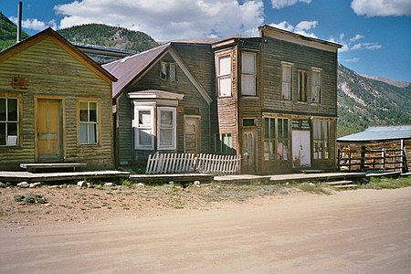
 Houses along Ashcroft, Colorado's Main Street, 2007
 -
 Token coin with the value of $1.00, issued by the Rawley Mine Commissary in Bonanza, Colorado
 -
-
 Caribou, Colorado circa 1911
 -
 Caribou, Colorado in 2005
 -
 The remains of an old cabin at Dyersville, Colorado
 -
 An abandoned house in Eastonville, Colorado
 -
 The Arcade Saloon in Eldora, Colorado in 1898
 -
 Remains of the old ore mill in Eureka, Colorado
 -
 Remains of the Bassick silver mine, Querida, Colorado
 -
 Saint Elmo, Colorado in 2005


See also
 Geography portal
 History portal
 United States portal
 Colorado portal


- List of places in Colorado
- Bibliography of Colorado
- Geography of Colorado
- History of Colorado
- Index of Colorado-related articles
- List of Colorado-related lists
- Outline of Colorado
Notes
- ^ a b c d e f g h i j k l m n o p q r s t u v w x y z aa ab ac ad ae af ag ah ai aj ak al am an ao ap aq ar as at au av aw ax ay az ba bb bc bd be bf bg bh bi bj bk bl bm bn bo bp bq br bs bt bu bv bw bx by bz ca cb cc cd ce cf cg ch ci cj ck cl cm cn co cp cq cr cs ct cu cv cw cx cy cz da db dc dd de df dg dh di dj dk dl dm dn do dp dq dr ds dt du dv dw dx dy dz ea eb ec ed ee ef eg eh ei ej ek el em en eo ep eq er es et eu ev The year the local post office opened[2][3]
- ^ a b c d e f g h i j k l m n o p q r s t u v w x y z aa ab ac ad ae af ag ah ai aj ak al am an ao ap aq ar as at au av aw ax ay az ba bb bc bd be bf bg bh bi bj bk bl bm bn bo bp bq br bs bt bu bv bw bx by bz ca cb cc cd ce cf cg ch ci cj ck cl cm cn co cp cq cr cs ct cu cv cw cx cy cz da db dc dd de df dg dh di dj dk dl dm dn do dp dq dr ds dt du dv dw dx dy dz ea eb ec ed ee ef eg eh ei ej ek el em en eo ep eq er es et eu ev ew ex ey ez fa fb fc fd fe ff fg fh fi fj fk fl fm fn fo fp fq fr fs ft fu fv fw fx fy fz ga gb gc gd ge gf gg gh gi gj gk The year the local post office closed[2][3]
- ^ a b c d e f g h i j k l m n o p q r s t u v w x y z aa ab ac ad ae af ag ah ai aj ak al am an ao ap aq ar as at au av aw ax ay az ba bb bc bd be bf bg bh bi bj bk bl bm bn bo bp bq br bs bt The year the community was founded
- ^ a b c d e f g h i j k l m n o p q r s The year the community was abandoned
- ^ The Granada War Relocation Center opened on August 27, 1942.
- ^ The Granada War Relocation Center closed on October 15, 1945.
- ^ Located at an elevation of 11,185 feet (3,409 m), the Animas Forks, Colorado Territory post office (became Animas Forks, Colorado on August 1, 1876) was the highest in the United States from February 8, 1875 to February 9, 1876 and again from September 25 to October 15, 1879.
- ^ On November 28, 1859, the Provisional Government of the Territory of Jefferson created 12 counties, with Arapahoe City as the first seat of Jefferson County, Jefferson Territory.[4] On January 17, 1860, Arapahoe City shortened its name to Arapahoe.[2] On November 6, 1860, the Jefferson Territory moved the seat of Jefferson County to Golden City.
- ^ Located at an elevation of 12,230 feet (3,728 m), Arastra, Colorado was the highest elevation town to ever have a United States post office.
- ^ Auraria is now a part of the City and County of Denver.
- ^ Auraria was organized on November 6, 1858.
- ^ a b On December 3, 1859, the Provisional Government of the Territory of Jefferson consolidated the towns of Denver City, Auraria, and Highland into the City of Denver, Auraria, and Highland. Auraria and Highland are now neighborhoods of the City and County of Denver.
- ^ On November 1, 1861, the Territory of Colorado created 17 original counties, with Autobees Plaza as the original seat of Huerfano County, Colorado Territory, serving until 1868. Autobees Plaza is now located in Pueblo County.
- ^ On September 12, 1865, Little Orphan changed its name to Badito.[2] Badito served as the seat of Huerfano County, Colorado Territory from 1868 until 1874.
- ^ Bent's Old Fort was built in 1833.
- ^ Bent's Old Fort was destroyed in 1849.
- ^ Boggsville was the last home of Kit Carson from 1867 until his death in 1868. Boggsville served as the seat of Bent County, Colorado Territory from 1870 until 1872.
- ^ The residents of Bonanza City reactivated the Town of Bonanza.
- ^ On January 7, 1862, county voters selected Laurette as the new seat of Park County, Colorado Territory. On December 21, 1865, Laurette changed its name to Buckskin, commonly known as Buckskin Joe.[2] Buckskin Joe served as county seat until November 7, 1867.
- ^ a b On November 1, 1861, the Territory of Colorado created 17 original counties, with Frankstown as the original seat of Douglas County, Colorado Territory. In 1864, the county seat and its post office moved 3 miles (5 km) south to the California Ranch stage stop, which took the name Franktown.[2]
- ^ California Ranch is now a part of the Franktown CDP. The Franktown CDP had 409 residents at the 2020 United States Census.
- ^ In 1874, the Douglas County seat was moved from Franktown (previously California Ranch) to the new railroad town of Castle Rock.
- ^ Camp Hale was opened in 1942.
- ^ Camp Hale was demolished in 1945.
- ^ Carbonate served as the original seat of Garfield County, Colorado for several months after the county was created on February 10, 1883.
- ^ On November 4, 2014, the property owners of Carbonate, Colorado voted to reactivate the town government despite having no year-round residents since the 1890 United States Census.[9]
- ^ The Caribou Ranch recording studios were located near the ghost town of Caribou.
- ^ Located at an elevation of 11,574 feet (3,528 m), the Carson, Colorado post office was the highest in the United States from September 16, 1889 to June 14, 1895.
- ^ Chivington was named for the Reverend John Milton Chivington, a hero of the Battle of Glorieta Pass and the perpetrator of the Sand Creek Massacre.
- ^ Located at Tennessee Pass at an elevation of 11,342 feet (3,457 m), the Climax station on the Denver, South Park and Pacific Railroad was the highest railroad station in North America from its construction in 1884 until 1904 and again from 1928 until it was removed in 1937.
- ^ Located at an elevation of 11,342 feet (3,457 m), the Climax, Colorado post office was the highest in the United States from March 31, 1919 to January 4, 1974.
- ^ The year the town site was demolished
- ^ Located on Rollins Pass at an elevation of 11,723 feet (3,573 m), Corona was the highest railroad station in North America.
- ^ Dayton served as the seat of Lake County, Colorado Territory from 1866 until 1868.
- ^ The site of Dayton is now in the Twin Lakes CDP. The Twin Lakes CDP had 204 residents at the 2020 United States Census.
- ^ Dearfield, Colorado was an African American agricultural community founded by Oliver Toussaint Jackson in 1910.
- ^ a b The year the community was platted
- ^ Dearfield was never granted a post office.
- ^ Eldora is now a part of the Eldora CDP. The Eldora CDP had 140 residents at the 2020 United States Census.
- ^ Fulford is now a part of the Fulford CDP. The Fulford CDP lost both of its residents before the 2020 United States Census.
- ^ Goldfield is now a part of the Goldfield CDP. The Goldfield CDP had 63 residents at the 2020 United States Census.
- ^ The Rocky Mountain Biological Laboratory was founded in 1928 near the remains of Gothic, Colorado.
- ^ Highland is now a part of the City and County of Denver.
- ^ Highland was platted in December 1858.
- ^ Located at an elevation of 11,428 feet (3,483 m), the Holy Cross, Colorado post office was the highest in the United States from November 11, 1883 to September 15, 1889.
- ^ Howardsville served as the original seat of La Plata County, Colorado Territory since the county was created on February 10, 1874, until January 31, 1876.
- ^ Ludlow was the site of the Ludlow Massacre of 1914.
- ^ a b Mayday was built upon the remnants of the earlier Parrott City.
- ^ Montana is now a part of the City and County of Denver.
- ^ Montana was the first gold camp of the Pike's Peak Gold Rush.
- ^ In 1859, most of the residents of Montana left for the Cherry Creek Diggings.
- ^ The residents of Montezuma reactivated the Town of Montezuma.
- ^ Mount Vernon was the home of Jefferson Territorial Governor Robert Williamson Steele and the administrative capital of the Provisional Government of the Territory of Jefferson.
- ^ Norrie is now a part of the Norrie CDP. The Norrie CDP had seven residents at the 2020 United States Census.
- ^ On November 1, 1861, the Territory of Colorado created 17 original counties, with Oro City as the original seat of Lake County, Colorado Territory, serving until 1866.
- ^ Located at an elevation of 10,708 feet (3,264 m), the Oro City, Kansas Territory post office (became Oro City, Colorado Territory on February 28, 1861) was the highest in the United States from February 16 to November 13, 1861, and again from January 25, 1873 to February 7, 1875.
- ^ On November 1, 1861, the Territory of Colorado created 17 original counties, with Parkville as the original seat of Summit County, Colorado Territory. Parkville served as county seat until the following year.
- ^ On January 31, 1876, county voters selected Parrott City as the new seat of La Plata County, Colorado Territory, and after statehood on August 1, 1876, the seat of La Plata County, Colorado until 1881.
- ^ Poudre City was destroyed by the collapse of the Chambers Lake Dam on June 10, 1891.
- ^ Located at an elevation of 11,431 feet (3,484 m), the Rexford, Colorado post office was the highest in the United States from January 9, 1882 to November 10, 1883.
- ^ St. Charles is now a part of the City and County of Denver.
- ^ St. Charles was platted on September 24, 1858.
- ^ St. Charles was "annexed" by the Denver City Town Company on November 17, 1858.
- ^ On November 28, 1859, the Provisional Government of the Territory of Jefferson created 12 counties, with Saint Vrain as the seat of St. Vrain County, Jefferson Territory.[4] On November 1, 1861, the new Territory of Colorado created 17 original counties, with Saint Vrain as the original seat of Weld County, Colorado Territory, serving until 1868.
- ^ San Juan City served as the original seat of Hinsdale County, Colorado Territory from the time the county was created on February 10, 1874, until 1875. On June 4, 1874, San Juan City officially shortened its name to San Juan, although it was still commonly known as San Juan City.[2]
- ^ San Juan was located in Hinsdale County until the creation of Mineral County on March 27, 1893.
- ^ Serene was the site of the Columbine Mine Massacre of 1927.
- ^ South Denver is now a part of the City and County of Denver.
- ^ The City of Denver annexed the Town of South Denver in 1894.
- ^ Located at an elevation of 11,287 feet (3,440 m), the Summit, Colorado Territory post office (became Summit, Colorado on August 1, 1876 and name changed to Summitville, Colorado on November 17, 1880) was the highest in the United States from February 10, 1876 to September 24, 1879, and again from October 16, 1879 to January 8, 1882.
- ^ Tarryall City was the seat of Park County, Jefferson Territory and then Park County, Colorado Territory from its creation on November 1, 1861 until 1866.
- ^ Ula served as the original seat of Custer County, Colorado from the time the county was created on March 9, 1877, until 1878.
- ^ Wason served eight months as the original seat of Mineral County, Colorado, from the creation of the county on March 27, 1893, until November 7 of that year.
References
- ^ a b "Geographic Names Information System". United States Geological Survey, United States Department of the Interior. Retrieved September 12, 2023.
- ^ a b c d e f g Bauer, William H.; Ozment, James L.; Willard, John H. (1990). Colorado Post Offices 1859–1989. Golden, Colorado: Colorado Railroad Historical Foundation. ISBN 0-918654-42-4.
- ^ a b "Postal History". United States Postal Service. Retrieved September 12, 2023.
- ^ a b "An Act Defining the Boundaries of Counties and for other purposes". Provisional Laws and Joint Resolutions of the General Assembly of Jefferson Territory. General Assembly of the Provisional Government of the Territory of Jefferson. November 28, 1859. Retrieved November 12, 2023.
- ^ Godwin, Larry. "Silver Lake Basin: A Mining Chronicle". Western Mining History. Retrieved September 14, 2023.
- ^ Brooks, Kent (2018). Old Boston: As Wild As They Come. Springfield, Colorado: Lonesome Prairie Publications. ISBN 978-1732258501.
- ^ "Calcite". Museum Blog. Cañon City, CO: Royal Gorge Regional Museum & History Center. June 30, 2018. Retrieved February 20, 2020.
- ^ "Ghost Town Calcite Photography". Ghost Towns. Coloradopast.com. August 17, 2009. Retrieved February 20, 2020.
- ^ Stroud, John (November 8, 2014). "Yes, that's a town — by 9-0 vote". Glenwood Springs Post Independent. Archived from the original on March 6, 2017. Retrieved May 10, 2021.
- ^ Wilbur Fiske Stone (1919). History of Colorado. S. J. Clarke. p. 376.
- Writers' Program of the Work Projects Administration in the State of Colorado (1947). Ghost towns of Colorado. Hastings House.
- Bauer, Carolyn (1987). Colorado Ghost Towns: Remnants of the Mining Days. Primer Publishers. ISBN 1-55838-067-1.
- Boyd, Leanne; H. Glenn Carson (1984). Atlas of Colorado Ghost Towns. Carson Enterprises. ISBN 0-941620-19-0.
- Brown, Robert (1972). Colorado Ghost Towns - Past and Present. Caxton Press. ISBN 0-87004-218-1.
- Brown, Robert (2003). Ghost Towns of the Colorado Rockies. Caxton Press. ISBN 0-87004-342-0.
- Brown, Robert (1963). Jeep Trails to Colorado Ghost Towns. Caxton Press. ISBN 0-87004-021-9.
- Dallas, Sandra (1988). Colorado Ghost Towns and Mining Camps. Norman, Oklahoma: University of Oklahoma Press. ISBN 0-8061-2084-3.
- Eberhart, Perry (1959). Guide to the Colorado Ghost Towns and Mining Camps.
External links
Colorado at Wikipedia's sister projects
 Media from Commons
 News from Wikinews
 Quotations from Wikiquote
 Travel information from Wikivoyage
- Colorado state government website
- Colorado tourism website
- History Colorado website
- Ghost town and historic photos by Coloradopast.com
- Colorado ghost town photos by Rocky Mountain Profiles
- v
- t
- e
Denver (capital)
- Bibliography
- Index
- Outline
- Climate change
- Colleges
- Coloradans
- Elections
- Federal lands
- Geography
- Government
- Historic places
- History
- Images
- Indian reservations
- Law
- Lists
- Military
- Mountains
- Municipalities
- Museums
- National Forests
- National Parks
- Paleontology
- Prehistoric sites
- Prehistory
- Protected areas
- Railroads
- Rivers
- Slavery
- Statistical areas
- Symbols
- Timeline
- Tourist attractions
- Towns
- Trails
- Transportation
- Wildernesses
- Alamosa
- Arvada
- Aspen
- Aurora
- Black Hawk
- Boulder
- Brighton
- Broomfield
- Brush
- Burlington
- Cañon City
- Castle Pines
- Centennial
- Central City
- Cherry Hills Village
- Colorado Springs
- Commerce City
- Cortez
- Craig
- Cripple Creek
- Dacono
- Delta
- Denver
- Durango
- Edgewater
- Englewood
- Evans
- Federal Heights
- Florence
- Fort Collins
- Fort Lupton
- Fort Morgan
- Fountain
- Fruita
- Glendale
- Glenwood Springs
- Golden
- Grand Junction
- Greeley
- Greenwood Village
- Gunnison
- Holyoke
- Idaho Springs
- La Junta
- Lafayette
- Lakewood
- Lamar
- Las Animas
- Leadville
- Littleton
- Lone Tree
- Longmont
- Louisville
- Loveland
- Manitou Springs
- Monte Vista
- Montrose
- Northglenn
- Ouray
- Pueblo
- Rifle
- Rocky Ford
- Salida
- Sheridan
- Steamboat Springs
- Sterling
- Thornton
- Trinidad
- Victor
- Walsenburg
- Westminster
- Wheat Ridge
- Woodland Park
- Wray
- Yuma
- Adams
- Alamosa
- Arapahoe
- Archuleta
- Baca
- Bent
- Boulder
- Broomfield
- Chaffee
- Cheyenne
- Clear Creek
- Conejos
- Costilla
- Crowley
- Custer
- Delta
- Denver
- Dolores
- Douglas
- Eagle
- El Paso
- Elbert
- Fremont
- Garfield
- Gilpin
- Grand
- Gunnison
- Hinsdale
- Huerfano
- Jackson
- Jefferson
- Kiowa
- Kit Carson
- La Plata
- Lake
- Larimer
- Las Animas
- Lincoln
- Logan
- Mesa
- Mineral
- Moffat
- Montezuma
- Montrose
- Morgan
- Otero
- Ouray
- Park
- Phillips
- Pitkin
- Prowers
- Pueblo
- Rio Blanco
- Rio Grande
- Routt
- Saguache
- San Juan
- San Miguel
- Sedgwick
- Summit
- Teller
- Washington
- Weld
- Yuma
- Central Colorado
- Eastern Plains
- Colorado Mineral Belt
- Colorado Piedmont
- Colorado Plateau
- Colorado Western Slope
- Denver Metropolitan Area
- Four Corners Region
- Front Range Urban Corridor
- High Plains
- North Central Colorado Urban Area
- Northwestern Colorado
- San Luis Valley
- South-Central Colorado
- South Central Colorado Urban Area
- Southern Rocky Mountains
- Southwest Colorado
 Colorado portal
38°59′50″N 105°32′52″W / 38.9972°N 105.5478°W / 38.9972; -105.5478 (State of Colorado)


