List of longest rivers of Canada
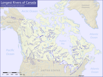

Among the longest rivers of Canada are 47 streams of at least 600 km (370 mi). In the case of some rivers such as the Columbia, the length listed in the table below is solely that of the main stem. In the case of others such as the Mackenzie, it is the combined lengths of the main stem and one or more upstream tributaries, as noted. Excluded from the list are rivers such as the Dauphin, a short connecting link between lakes Manitoba and Winnipeg, with main stems of 100 km (62 mi) or less. Also excluded are rivers such as the Mississippi, the main stems of which do not enter Canada even though some of their tributaries do.
Nine rivers in this list cross international boundaries or form them. Four—the Yukon, Columbia, Porcupine, and Kootenay—begin in Canada and flow into the United States. Five—the Milk, Pend d'Oreille, Saint Lawrence, Red, and Saint John—begin in the United States and flow into Canada. Of these, the Milk and the Kootenay cross the international border twice, the Milk leaving and then re-entering the United States, the Kootenay leaving and then re-entering Canada.[1] The drainage basins of these nine rivers extend into both countries; in addition, the drainage basins of six others—the Fraser, Assiniboine, South Saskatchewan, Saskatchewan, Nelson, and Winnipeg—extend into the United States even though their main stems flow entirely within Canada.
Sources report hydrological quantities with varied precision. Biologist and author Ruth Patrick, describing a table of high-discharge rivers, wrote that data on discharge, drainage area, and length varied widely among authors whose works she consulted. "It seems", she said, "that the wisest course is to regard data tables such as the present one as showing the general ranks of rivers, and not to place too much importance on minor (10–20%) differences in figures."[2]
Table
The primary source for data in the table below is The Atlas of Canada; other sources are as noted. Discharge refers to the flow at the mouth except as noted. U.S. states appear in italics. Abbreviations are as follows: "km" for "kilometre", "mi" for "mile", "s" for "second", "m" for "metre", and "ft" for "foot".
| Key | |||||
|---|---|---|---|---|---|
| † River is not entirely within Canada. | |||||
| ‡ Watershed is not entirely within Canada. | |||||
| # | Name | Mouth | Length[3] | Source[n 1] | Watershed area[3] | Discharge[3][5] | Provinces, states | Image |
|---|---|---|---|---|---|---|---|---|
| 1 | Mackenzie River | Beaufort Sea 69°21′59″N 133°54′10″W / 69.36639°N 133.90278°W / 69.36639; -133.90278 (Mackenzie River (mouth))[6] | 4,241 km 2,635 mi [n 2] | Thutade Lake 56°44′00″N 127°31′00″W / 56.73333°N 127.51667°W / 56.73333; -127.51667 (Finlay River (source)) | 1,805,200 km2 697,000 mi2 | 9,700 m3/s 340,000 ft3/s | Northwest Territories |  |
| 2 | Yukon River | Bering Sea 62°35′55″N 164°48′00″W / 62.59861°N 164.80000°W / 62.59861; -164.80000 (Yukon River (mouth))[8] | 3,185 km 1,979 mi †[n 3] | Teslin Lake 59°37′00″N 132°09′00″W / 59.61667°N 132.15000°W / 59.61667; -132.15000 (Yukon River (source)) | 839,200 km2 324,000 mi2 ‡[n 4] | 6,340 m3/s 224,000 ft3/s[9] | British Columbia, Yukon, Alaska |  |
| 3 | Saint Lawrence River | Gulf of Saint Lawrence 49°40′00″N 64°30′00″W / 49.66667°N 64.50000°W / 49.66667; -64.50000 (Saint Lawrence River (mouth))[10] | 3,058 km 1,900 mi †[n 5] | Seven Beaver Lake 47°30′04″N 91°49′51″W / 47.50111°N 91.83083°W / 47.50111; -91.83083 (Saint Louis River (source))[11] | 1,344,200 km2 519,000 mi2 ‡[n 6] | 9,850 m3/s 348,000 ft3/s | Minnesota, Wisconsin, Ontario, Michigan, Ohio, New York, Quebec |  |
| 4 | Nelson River | Hudson Bay 57°04′05″N 92°30′08″W / 57.06806°N 92.50222°W / 57.06806; -92.50222 (Nelson River (mouth))[12] | 2,575 km 1,600 mi [n 7] | Bow Glacier 51°40′00″N 116°27′00″W / 51.66667°N 116.45000°W / 51.66667; -116.45000 (Bow River (source)) | 892,300 km2 344,500 mi2 ‡[n 8] | 2,370 m3/s 84,000 ft3/s | Manitoba |  |
| 5 | Slave River | Great Slave Lake 61°18′00″N 113°40′04″W / 61.30000°N 113.66778°W / 61.30000; -113.66778 (Slave River (mouth))[13] | 2,338 km 1,453 mi [n 9] | Thutade Lake 56°44′00″N 127°31′00″W / 56.73333°N 127.51667°W / 56.73333; -127.51667 (Finlay River (source)) | 616,400 km2 238,000 mi2 | 3,437 m3/s 121,400 ft3/s[14] | Alberta, Northwest Territories |  |
| 6 | Columbia River | Pacific Ocean 46°14′39″N 124°03′29″W / 46.24417°N 124.05806°W / 46.24417; -124.05806 (Columbia River (mouth))[15] | 2,000 km 1,243 mi †[n 10] | Columbia Lake 50°09′53″N 115°50′19″W / 50.16472°N 115.83861°W / 50.16472; -115.83861 (Columbia River source) | 671,300 km2 259,200 mi2 ‡[n 11] | 7,730 m3/s 273,000 ft3/s[16] | British Columbia, Washington, Oregon |  |
| 7 | Saskatchewan River | Lake Winnipeg 53°11′20″N 99°15′18″W / 53.18889°N 99.25500°W / 53.18889; -99.25500 (Saskatchewan River (mouth))[17] | 1,939 km 1,205 mi [n 12] | Bow Glacier 51°40′00″N 116°27′00″W / 51.66667°N 116.45000°W / 51.66667; -116.45000 (Bow River (source)) | 335,900 km2 129,700 mi2 ‡[n 13] | 700 m3/s 25,000 ft3/s | Alberta, Saskatchewan, Manitoba |  |
| 8 | Peace River | Slave River 59°00′01″N 111°24′47″W / 59.00028°N 111.41306°W / 59.00028; -111.41306 (Peace River (mouth))[18] | 1,923 km 1,195 mi [n 14] | Thutade Lake 56°44′00″N 127°31′00″W / 56.73333°N 127.51667°W / 56.73333; -127.51667 (Finlay River (source)) | 302,500 km2 116,800 mi2 | 2,118 m3/s 74,800 ft3/s[19] | British Columbia, Alberta |  |
| 9 | Churchill River (Hudson Bay) | Hudson Bay 58°47′45″N 94°12′15″W / 58.79583°N 94.20417°W / 58.79583; -94.20417 (Churchill River (mouth))[20] | 1,609 km 1,000 mi [n 15] | Churchill Lake 55°49′02″N 108°22′52″W / 55.81722°N 108.38111°W / 55.81722; -108.38111 (Churchill River (source)) | 281,300 km2 108,600 mi2 | 1,200 m3/s 42,000 ft3/s | Alberta, Saskatchewan, Manitoba |  |
| 10 | South Saskatchewan River | Saskatchewan River 53°15′00″N 105°05′02″W / 53.25000°N 105.08389°W / 53.25000; -105.08389 (South Saskatchewan River (mouth))[21] | 1,392 km 865 mi [n 16] | Bow Glacier 51°40′00″N 116°27′00″W / 51.66667°N 116.45000°W / 51.66667; -116.45000 (Bow River (source)) | 146,100 km2 56,400 mi2 ‡[n 17] | 280 m3/s 9,900 ft3/s | Alberta, Saskatchewan |  |
| 11 | Fraser River | Strait of Georgia 49°07′00″N 123°10′59″W / 49.11667°N 123.18306°W / 49.11667; -123.18306 (Fraser River (mouth))[22] | 1,375 km 854 mi | Fraser Pass 52°32′01″N 118°19′39″W / 52.53361°N 118.32750°W / 52.53361; -118.32750 (Fraser River (source)) | 233,100 km2 90,000 mi2 ‡[n 18] | 3,540 m3/s 125,000 ft3/s | British Columbia |  |
| 12 | North Saskatchewan River | Saskatchewan River 53°15′00″N 105°05′02″W / 53.25000°N 105.08389°W / 53.25000; -105.08389 (North Saskatchewan River (mouth))[23] | 1,287 km 800 mi | Saskatchewan Glacier 52°14′33″N 117°09′05″W / 52.24250°N 117.15139°W / 52.24250; -117.15139 (North Saskatchewan River (source)) | 122,800 km2 47,400 mi2 | 245 m3/s 8,700 ft3/s | Alberta, Saskatchewan |  |
| 13 | Ottawa River | Saint Lawrence River 45°33′59″N 74°23′11″W / 45.56639°N 74.38639°W / 45.56639; -74.38639 (Ottawa River (mouth))[24] | 1,271 km 790 mi | Laurentian Mountains 47°36′00″N 75°43′40″W / 47.60000°N 75.72778°W / 47.60000; -75.72778 (Ottawa River (source)) | 146,300 km2 56,500 mi2 | 1,950 m3/s 69,000 ft3/s | Quebec, Ontario |  |
| 14 | Athabasca River | Lake Athabasca 58°59′05″N 110°51′23″W / 58.98472°N 110.85639°W / 58.98472; -110.85639 (Athabasca River (mouth))[25] | 1,231 km 765 mi | Columbia Icefield 52°11′14″N 117°28′27″W / 52.18722°N 117.47417°W / 52.18722; -117.47417 (Athabasca River (source)) | 95,300 km2 36,800 mi2 [n 19] | 783 m3/s 27,700 ft3/s[26] | Alberta |  |
| 15 | Liard River | Mackenzie River 61°50′55″N 121°18′35″W / 61.84861°N 121.30972°W / 61.84861; -121.30972 (Liard River (mouth))[27] | 1,115 km 693 mi[28] | Saint Cyr Range 61°11′08″N 131°45′36″W / 61.18556°N 131.76000°W / 61.18556; -131.76000 (Liard River (source)) | 277,100 km2 107,000 mi2 | 2,446 m3/s 86,400 ft3/s[29] | Yukon, British Columbia, Northwest Territories |  |
| 16 | Assiniboine River | Red River 49°53′09″N 97°07′41″W / 49.88583°N 97.12806°W / 49.88583; -97.12806 (Assiniboine River (mouth))[30] | 1,070 km 660 mi | near Hazel Dell 52°15′53″N 103°08′48″W / 52.26472°N 103.14667°W / 52.26472; -103.14667 (Assiniboine River (source)) | 182,000 km2 70,000 mi2 ‡[n 20] | 45 m3/s 1,600 ft3/s | Saskatchewan, Manitoba |  |
| 17 | Milk River | Missouri River 48°03′26″N 106°19′07″W / 48.05722°N 106.31861°W / 48.05722; -106.31861 (Milk River (mouth))[31] | 1,005 km 625 mi †[n 21] | Blackfeet Indian Reservation 48°51′20″N 113°01′10″W / 48.85556°N 113.01944°W / 48.85556; -113.01944 (Milk River (source))[31] | 61,200 km2 23,600 mi2 ‡[n 22] | 18.9 m3/s 670 ft3/s[33] | Alberta, Montana |  |
| 18 | Albany River | James Bay 52°17′00″N 81°30′59″W / 52.28333°N 81.51639°W / 52.28333; -81.51639 (Albany River (mouth))[34] | 982 km 610 mi [n 23] | Cat Lake 51°45′00″N 91°53′00″W / 51.75000°N 91.88333°W / 51.75000; -91.88333 (Cat River (source)) | 135,200 km2 52,200 mi2 | 251 m3/s 8,900 ft3/s [n 24] | Ontario |  |
| 19 | Severn River | Hudson Bay 56°03′22″N 87°34′36″W / 56.05611°N 87.57667°W / 56.05611; -87.57667 (Severn River (mouth))[36] | 982 km 610 mi [n 25] | Deer Lake 52°37′00″N 94°40′00″W / 52.61667°N 94.66667°W / 52.61667; -94.66667 (Black Birch River (source)) | 102,800 km2 39,700 mi2 | 645 m3/s 22,800 ft3/s [n 26] | Ontario | |
| 20 | Back River | Chantrey Inlet 67°16′00″N 95°15′00″W / 67.26667°N 95.25000°W / 67.26667; -95.25000 (Back River (mouth))[39] | 974 km 605 mi [n 27] | near Aylmer Lake 64°25′00″N 108°27′00″W / 64.41667°N 108.45000°W / 64.41667; -108.45000 (Back River (source)) | 106,500 km2 41,120 mi2 | 612 m3/s 21,600 ft3/s[40] | Northwest Territories, Nunavut |  |
| 21 | Thelon River | Baker Lake 64°16′30″N 96°04′35″W / 64.27500°N 96.07639°W / 64.27500; -96.07639 (Thelon River (mouth))[41] | 904 km 562 mi | Lynx Lake 62°20′36″N 106°02′18″W / 62.34333°N 106.03833°W / 62.34333; -106.03833 (Thelon River (source)) | 142,400 km2 55,000 mi2 | 840 m3/s 30,000 ft3/s | Northwest Territories, Nunavut |  |
| 22 | La Grande River | James Bay 53°50′03″N 79°03′20″W / 53.83417°N 79.05556°W / 53.83417; -79.05556 (La Grande River (mouth))[42] | 893 km 555 mi | Lac Nichicun 53°12′30″N 70°56′00″W / 53.20833°N 70.93333°W / 53.20833; -70.93333 (La Grande River (source)) | 97,600 km2 37,700 mi2 | 1,690 m3/s 60,000 ft3/s | Quebec |  |
| 23 | Red River | Lake Winnipeg 50°23′47″N 96°48′39″W / 50.39639°N 96.81083°W / 50.39639; -96.81083 (Red River (mouth))[43] | 890 km 545 mi †[n 28] | Wahpeton and Breckinridge 46°15′52″N 96°35′55″W / 46.26444°N 96.59861°W / 46.26444; -96.59861[45] | 287,500 km2 111,000 mi2 ‡[n 29] | 236 m3/s 8,300 ft3/s[46] | North Dakota, Minnesota, Manitoba |  |
| 24 | Koksoak River | Ungava Bay 58°32′11″N 68°09′29″W / 58.53639°N 68.15806°W / 58.53639; -68.15806 (Koksoak River (mouth))[47] | 874 km 543 mi [n 30] | Lake Sevestre 52°32′23″N 68°01′15″W / 52.53972°N 68.02083°W / 52.53972; -68.02083 (Caniapiscau River (source)) | 133,400 km2 51,500 mi2 | 2,800 m3/s 99,000 ft3/s | Quebec |  |
| 25 | Churchill River (Atlantic) | Lake Melville 53°20′58″N 60°10′39″W / 53.34944°N 60.17750°W / 53.34944; -60.17750 (Churchill River (mouth))[48] | 856 km 532 mi [n 31] | Ashuanipi Lake 52°59′20″N 66°14′28″W / 52.98889°N 66.24111°W / 52.98889; -66.24111 (Ashuanipi River (source)) | 79,800 km2 30,800 mi2 | 1,580 m3/s 56,000 ft3/s | Newfoundland and Labrador |  |
| 26 | Coppermine River | Coronation Gulf 67°49′09″N 115°03′50″W / 67.81917°N 115.06389°W / 67.81917; -115.06389 (Coppermine River (mouth))[49] | 845 km 525 mi | Lac de Gras 64°35′02″N 111°11′24″W / 64.58389°N 111.19000°W / 64.58389; -111.19000 (Coppermine River (source)) | 50,800 km2 19,600 mi2[50] | 262 m3/s 9,300 ft3/s [n 32] | Northwest Territories, Nunavut |  |
| 27 | Dubawnt River | Thelon River 64°32′59″N 100°06′00″W / 64.54972°N 100.10000°W / 64.54972; -100.10000 (Dubawnt River (mouth))[51] | 842 km 523 mi | Abitau Lake 60°21′00″N 107°09′00″W / 60.35000°N 107.15000°W / 60.35000; -107.15000 (Dubawnt River (source)) | 57,500 km2 22,200 mi2 | 366 m3/s 12,900 ft3/s [n 33] | Northwest Territories, Nunavut | |
| 28 | Winnipeg River | Lake Winnipeg 50°37′54″N 96°19′13″W / 50.63167°N 96.32028°W / 50.63167; -96.32028 (Winnipeg River (mouth))[53] | 813 km 505 mi [n 34] | Trap Lake 49°12′42″N 90°26′58″W / 49.21167°N 90.44944°W / 49.21167; -90.44944 (Winnipeg River (source)) | 135,800 km2 52,400 mi2 ‡[n 35] | 850 m3/s 30,000 ft3/s[54] | Ontario, Manitoba |  |
| 29 | Kootenay River | Columbia River 49°19′0″N 117°39′0″W / 49.31667°N 117.65000°W / 49.31667; -117.65000[55] | 780 km 485 mi † | Beaverfoot Range 51°03′21″N 116°21′55″W / 51.05583°N 116.36528°W / 51.05583; -116.36528 (Kootenay River (source)) | 50,300 km2 19,400 mi2 ‡[n 36] | 850 m3/s 30,000 ft3/s | British Columbia, Montana, Idaho |  |
| 30 | Nottaway River | James Bay 51°22′33″N 78°55′45″W / 51.37583°N 78.92917°W / 51.37583; -78.92917 (Nottaway River (mouth)) | 776 km 482 mi [n 37] | Lake Gilles 48°07′00″N 75°38′00″W / 48.11667°N 75.63333°W / 48.11667; -75.63333 (Megiscane River (source)) | 65,800 km2 25,400 mi2 | 1,190 m3/s 42000 ft3/s | Quebec | |
| 31 | Rupert River | James Bay 51°29′35″N 78°45′01″W / 51.49306°N 78.75028°W / 51.49306; -78.75028 (Rupert River (mouth))[56] | 763 km 474 mi [n 38] | north of Lake Mistassini 52°13′11″N 71°32′19″W / 52.21972°N 71.53861°W / 52.21972; -71.53861 (Temiscamie River (source)) | 43,400 km2 16,800 mi2 | 900 m3/s 32,000 ft3/s | Quebec |  |
| 32 | Eastmain River | James Bay 52°14′30″N 78°33′38″W / 52.24167°N 78.56056°W / 52.24167; -78.56056 (Eastmain River (mouth))[57] | 756 km 470 mi | Lac Bréhat 52°31′30″N 70°52′00″W / 52.52500°N 70.86667°W / 52.52500; -70.86667 (Eastmain River (source)) | 46,400 km2 17,900 mi2 | 930 m3/s 33,000 ft3/s | Quebec |  |
| 33 | Attawapiskat River | James Bay 52°57′12″N 82°17′43″W / 52.95333°N 82.29528°W / 52.95333; -82.29528 (Attawapiskat River (mouth))[58] | 748 km 465 mi [n 39] | Attawapiskat Lake 52°10′00″N 87°37′00″W / 52.16667°N 87.61667°W / 52.16667; -87.61667 (Attawapiskat River (source)) | 50,500 km2 19,500 mi2 | 263 m3/s 9,300 ft3/s [n 40] | Ontario | |
| 34 | Kazan River | Thelon River 64°02′30″N 95°29′04″W / 64.04167°N 95.48444°W / 64.04167; -95.48444 (Kazan River (mouth))[60] | 732 km 455 mi [n 41] | Ennadai Lake 60°55′00″N 101°20′00″W / 60.91667°N 101.33333°W / 60.91667; -101.33333 (Kazan River (source)) | 71,500 km2 27,600 mi2 | 540 m3/s 19,000 ft3/s | Nunavut | 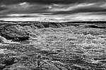 |
| 35 | Red Deer River | South Saskatchewan River 50°58′05″N 110°00′00″W / 50.96806°N 110.00000°W / 50.96806; -110.00000 (Red Deer River (mouth))[61] | 724 km 450 mi | Sawback Range 51°32′19″N 116°02′46″W / 51.53861°N 116.04611°W / 51.53861; -116.04611 (Red Deer River (source)) | 45,100 km2 17,400 mi2 | 70 m3/s 2,500 ft3/s | Alberta |  |
| 36 | Great Whale River | Hudson Bay 55°15′58″N 77°47′04″W / 55.26611°N 77.78444°W / 55.26611; -77.78444 (Great Whale River (mouth))[62] | 724 km 450 mi | Lake Saint-Lusson 54°49′30″N 70°32′17″W / 54.82500°N 70.53806°W / 54.82500; -70.53806 (Great Whale River (source)) | 42,700 km2 16,500 mi2 | 680 m3/s 24,000 ft3/s | Quebec |  |
| 37 | Porcupine River | Yukon River 66°35′42″N 145°18′32″W / 66.59500°N 145.30889°W / 66.59500; -145.30889 (Porcupine River (mouth))[63] | 721 km 448 mi † | Ogilvie Mountains 66°32′10″N 138°22′16″W / 66.53611°N 138.37111°W / 66.53611; -138.37111 (Porcupine River (source)) | 117,900 km2 45,500 mi2 ‡[n 42] | 414 m3/s 14,600 ft3/s[64] | Yukon, Alaska |  |
| 38 | Pend d'Oreille River | Columbia River 48°59′59″N 117°37′00″W / 48.99972°N 117.61667°W / 48.99972; -117.61667 (Pend d'Oreille River (mouth))[65] | 703 km 437 mi †[n 43] | near Butte 46°04′32″N 112°27′56″W / 46.07556°N 112.46556°W / 46.07556; -112.46556 (Silver Bow Creek (source))[69] | 66,900 km2 25,800 mi2 ‡[n 44] | 820 m3/s 29,000 ft3/s[70] | Idaho, Washington, British Columbia |  |
| 39 | Hay River | Great Slave Lake 60°51′50″N 115°44′04″W / 60.86389°N 115.73444°W / 60.86389; -115.73444 (Hay River (mouth))[71] | 702 km 436 mi | near Zama Lake 58°14′14″N 118°51′34″W / 58.23722°N 118.85944°W / 58.23722; -118.85944 (Hay River (source)) | 48,200 km2 18,600 mi2 | 113 m3/s 4,000 ft3/s[72] | Alberta, Northwest Territories |  |
| 40 | Saguenay River | Saint Lawrence River 48°07′59″N 69°43′59″W / 48.13306°N 69.73306°W / 48.13306; -69.73306 (Saguenay River (mouth))[73] | 698 km 434 mi [n 45] | near Otish Mountains 52°16′17″N 70°48′38″W / 52.27139°N 70.81056°W / 52.27139; -70.81056 (Saguenay River (source)) | 88,000 km2 34,000 mi2 | 1,750 m3/s 62,000 ft3/s | Quebec |  |
| 41 | Anderson River | Beaufort Sea 69°43′00″N 129°00′09″W / 69.71667°N 129.00250°W / 69.71667; -129.00250 (Anderson River (mouth))[74] | 692 km 430 mi | northwest of Great Bear Lake 66°57′00″N 124°36′00″W / 66.95000°N 124.60000°W / 66.95000; -124.60000 (Anderson River (source)) | 142 m3/s 5,000 ft3/s [n 46] | Northwest Territories | ||
| 42 | Peel River | Mackenzie River 67°41′49″N 134°31′58″W / 67.69694°N 134.53278°W / 67.69694; -134.53278 (Peel River (mouth))[75] | 684 km 425 mi [n 47] | Gill Lake 65°19′00″N 139°49′00″W / 65.31667°N 139.81667°W / 65.31667; -139.81667 (Ogilvie River (source)) | 73,600 km2 28,400 mi2 | 103 m3/s 3,600 ft3/s[76] | Yukon, Northwest Territories | 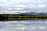 |
| 43 | Saint John River | Bay of Fundy 45°16′00″N 66°04′00″W / 45.26667°N 66.06667°W / 45.26667; -66.06667 (Saint John River (mouth)) | 673 km 418 mi † | Somerset County 46°33′47″N 69°53′05″W / 46.56306°N 69.88472°W / 46.56306; -69.88472 (Saint John River (source)) | 55,200 km2 21,300 mi2 ‡[n 48] | 1,130 m3/s 40,000 ft3/s | Maine, New Brunswick |  |
| 44 | Stewart River | Yukon River 63°17′30″N 139°24′42″W / 63.29167°N 139.41167°W / 63.29167; -139.41167 (Stewart River (mouth))[77] | 644 km 400 mi | Selwyn Mountains 64°06′35″N 131°42′25″W / 64.10972°N 131.70694°W / 64.10972; -131.70694 (Stewart River (source)) | 51,000 km2 20,000 mi2 | 675 m3/s 23,800 ft3/s[78] | Yukon |  |
| 45 | Horton River | Franklin Bay 69°56′00″N 126°48′09″W / 69.93333°N 126.80250°W / 69.93333; -126.80250 (Horton River (mouth))[79] | 618 km 384 mi | Kitikmeot Region, Nunavut 67°51′00″N 120°33′00″W / 67.85000°N 120.55000°W / 67.85000; -120.55000 (Horton River (source)) | 26,680 km2 10,300 mi2[80] | Nunavut, Northwest Territories |  | |
| 46 | English River | Winnipeg River 50°12′04″N 95°00′12″W / 50.20111°N 95.00333°W / 50.20111; -95.00333 (English River (mouth))[81] | 615 km 382 mi | near Marmion Lake 49°06′00″N 91°16′00″W / 49.10000°N 91.26667°W / 49.10000; -91.26667 (English River (source)) | 52,300 km2 20,200 mi2 | Ontario | ||
| 47 | Pelly River | Yukon River 62°46′46″N 137°20′13″W / 62.77944°N 137.33694°W / 62.77944; -137.33694 (Pelly River (mouth))[82] | 608 km 378 mi | Mackenzie Mountains 62°49′00″N 129°53′00″W / 62.81667°N 129.88333°W / 62.81667; -129.88333 (Pelly River (source)) | 51,000 km2 20,000 mi2 | 410 m3/s 14,000 ft3/s | Yukon |  |
See also
Notes and references
- Notes
- ^ Except as noted, source coordinates were derived via a topographic map search engine embedded in The Atlas of Canada.[4]
- ^ To the head of the Finlay River.[7]
- ^ To the head of the Nisutlin River. Of the total length of 3,185 km (1,979 mi), 1,149 km (714 mi) (about 36 percent) are in Canada.[7]
- ^ Split between 323,800 km2 (125,000 mi2), about 39 percent, in Canada and 515,400 km2 (199,000 mi2), about 61 percent, in the United States.[7]
- ^ To the head of the Saint Louis River in Minnesota.[7]
- ^ Split between 839,200 km2 (324,000 mi2) (about 62 percent) in Canada and 505,000 km2 (195,000 mi2) (about 38 percent) in the United States.[7]
- ^ To the head of the Bow River.[7]
- ^ Split between 690,900 square kilometres (266,800 sq mi), about 77 percent, in Canada and 201,400 square kilometres (77,800 sq mi), about 23 percent, in the United States. The totals for the two countries were derived by adding the U.S. watershed subtotals for the Assiniboine, Red, Winnipeg, and Saskatchewan rivers, which feed into the Nelson.[7]
- ^ Derived by adding the length of the Peace River (measured from its mouth to the headwaters of the Finlay River) to the length of the main stem of the Slave River.[7]
- ^ About 801 km (498 mi), 40 percent of the total, are in Canada.[7]
- ^ Split between 102,800 km2 (39,700 mi2) (about 15 percent) in Canada and 568,500 km2 (219,500 mi2) (about 85 percent) in the United States.[7]
- ^ To the head of the Bow River.[7]
- ^ Split between 334,100 km2 (129,000 sq mi) (about 99.5 percent) in Canada and 1,800 km2 (690 sq mi) (about 0.5 percent) in the United States.[7]
- ^ To the head of the Finlay River.[7]
- ^ To the head of Churchill Lake.[7]
- ^ To the head of the Bow River.[7]
- ^ Split between 144,300 km2 (55,700 sq mi) (about 99 percent) in Canada and 1,800 km2 (690 sq mi) (about 1 percent) in the United States.[7]
- ^ Split between 232,300 km2 (89,700 sq mi) (about 99.7 percent) in Canada and 800 km2 (310 sq mi) (about 0.3 percent) in the United States.[7]
- ^ Rivers of North America lists a basin size of 154,880 square kilometres (59,800 sq mi), but this includes Lake Athabasca, the Peace–Athabasca Delta, and the basins of the Fond du Lac River and some of the other streams flowing into the lake.[26]
- ^ Split between 160,600 km2 (62,000 mi2) (about 88 percent) in Canada and 21,400 km2 (8,300 mi2) (about 12 percent) in the United States.[7]
- ^ According to the Milk River Watershed Council, a 180-km (110 mi) stretch of the river flows through Canada. This amounts to about 18 percent of the river's total length.[32]
- ^ Split between 21,600 km2 (8,300 mi2) (about 35 percent) in Canada and 39,600 km2 (15,300 mi2) (about 65 percent) in the United States.[7]
- ^ To the head of the Cat River.[7]
- ^ Based on data from the years 1968–69, 73, and 75–84 at Hat Island,[35] about 200 kilometres (120 mi) from the mouth. Distance from mouth estimated with a measurement tool embedded in The Atlas of Canada topographic maps.[4]
- ^ To the head of the Black Birch River.[7]
- ^ Based on data from the years 1973–74, 77–79, and 83–84 at Limestone Rapids,[37] about 40 kilometres (25 mi) from the mouth.[38]
- ^ To the head of Muskox Lake.[7]
- ^ Split between 255 kilometres (158 mi) or about 29 percent in Canada and 635 kilometres (395 mi) or about 71 percent in the United States.[44]
- ^ Split between 138,600 km2 (53,500 sq mi) (about 48 percent) in Canada and 148,900 km2 (57,500 sq mi) (about 52 percent) in the United States.[7]
- ^ To the head of the Caniapiscau River.[7]
- ^ To the head of the Ashuanipi River.[7]
- ^ This is the mean discharge for a point about 100 kilometres (62 mi) from the mouth rather than at the mouth.[50]
- ^ Measured by a gauge at the outlet of Marjorie Lake, about 50 kilometres (31 mi) from the mouth. Flow derived by converting km3/yr to m3/s.[52] Distance from mouth estimated with a measurement tool embedded in The Atlas of Canada topographic maps.[4]
- ^ To the head of the Firesteel River.[7]
- ^ Split between 106,500 square kilometres (41,100 sq mi) in Canada, about 78 percent, and 29,300 square kilometres (11,300 sq mi), about 22 percent, in the United States.[7]
- ^ Split between 37,700 square kilometres (14,600 sq mi), about 52 percent, in Canada and 12,600 square kilometres (4,900 sq mi), about 48 percent, in the United States.
- ^ To the head of the Megiscane River.[7]
- ^ To the head of the Temiscamie River.[7]
- ^ To the head of Attawapiskat Lake.[7]
- ^ Based on data from the years 1967–80 and 82–84 at the source, Attawpiskat Lake, rather than at the mouth.[59]
- ^ To the head of Ennadai Lake.[7]
- ^ Split between 61,400 square kilometres (23,700 sq mi) in Canada, about 52 percent, and 56,500 square kilometres (21,800 sq mi), about 48 percent, in the United States.[7]
- ^ To the head of the Silver Bow Creek. Length derived by adding the distance from the mouth to the head of Pend Oreille Lake, shown on topo maps as about 220 kilometres (140 mi)[66] to the length (about 480 kilometres (300 mi) of the Clark Fork River and its headwater tributary, Silver Bow Creek.[67] Of this total, only 22 km (14 mi), about 3 percent, are in Canada.[68]
- ^ Split between 1,600 square kilometres (620 sq mi) in Canada, about 2 percent, and 65,000 square kilometres (25,000 sq mi), about 98 percent, in the United States.[68]
- ^ To the head of the Peribonka River.[7]
- ^ Measured by a gauge below the Carnwath River, about 150 kilometres (93 mi) from the Anderson River mouth. Flow derived by converting km3/yr to m3/s.[52] Distance from mouth estimated with a measurement tool embedded in The Atlas of Canada topographic maps.[4]
- ^ To the head of the Ogilvie River.[7]
- ^ Split between 35,000 square kilometres (14,000 sq mi) (about 63 percent) in Canada and 19,700 square kilometres (7,600 sq mi) (about 37 percent) in the United States.[7]
- References
- ^ The Road Atlas. Chicago, Illinois: Rand McNally & Company. 2008. ISBN 978-0-528-93961-7.
- ^ Patrick, Ruth (1995). Rivers of the United States: Volume II: Chemical and Physical Characteristics. New York: John Wiley & Sons. p. 24. ISBN 0-471-10752-2.
- ^ a b c From The Atlas of Canada unless otherwise noted
- ^ a b c d "The Atlas of Canada, Advanced Search". Natural Resources Canada. Archived from the original on August 25, 2011. Retrieved May 18, 2011.
- ^ Measured at the mouth unless otherwise noted
- ^ "Mackenzie River, Northwest Territories". The Atlas of Canada. Natural Resources Canada. Archived from the original on October 6, 2012. Retrieved May 18, 2011.
- ^ a b c d e f g h i j k l m n o p q r s t u v w x y z aa ab ac ad ae af ag ah ai "Rivers". The Atlas of Canada. Natural Resources Canada. Archived from the original on February 2, 2007. Retrieved May 15, 2011.
- ^ "Yukon River". Geographic Names Information System. United States Geological Survey. March 31, 1981. Retrieved February 4, 2011.
- ^ Benke and Cushing, p. 796
- ^ "Saint Lawrence River". The Atlas of Canada. Natural Resources Canada. Archived from the original on July 6, 2011. Retrieved February 3, 2011.
- ^ "Saint Louis River". Geographic Names Information System. United States Geological Survey (USGS). January 11, 1980. Retrieved May 19, 2011.
- ^ "Nelson River, Manitoba". The Atlas of Canada. Natural Resources Canada. Archived from the original on June 8, 2011. Retrieved May 16, 2011.
- ^ "Slave River, Northwest Territories". The Atlas of Canada. Natural Resources Canada. Archived from the original on October 6, 2012. Retrieved May 30, 2011.
- ^ Benke and Cushing, p. 843
- ^ "Columbia River". Geographic Names Information System. United States Geological Survey. November 28, 1980. Retrieved August 5, 2010.
- ^ Benke and Cushing, p. 646
- ^ "Saskatchewan River, Manitoba". The Atlas of Canada. Natural Resources Canada. Retrieved May 16, 2011.[permanent dead link]
- ^ "Peace River, Alberta". The Atlas of Canada. Natural Resources Canada. Retrieved May 16, 2011.[permanent dead link]
- ^ Benke and Cushing, p. 844
- ^ "Churchill River, Manitoba". The Atlas of Canada. Natural Resources Canada. Retrieved May 8, 2011.[permanent dead link]
- ^ "South Saskatchewan River, Saskatchewan". The Atlas of Canada. Natural Resources Canada. Retrieved May 7, 2011.[permanent dead link]
- ^ "Fraser River, British Columbia". The Atlas of Canada. Natural Resources Canada. Archived from the original on October 6, 2012. Retrieved May 25, 2011.
- ^ "North Saskatchewan River, Saskatchewan". The Atlas of Canada. Natural Resources Canada. Retrieved May 16, 2011.[permanent dead link]
- ^ "Ottawa River, Ontario". Natural Resources Canada. Retrieved May 16, 2011.[permanent dead link]
- ^ "Athabasca River, Alberta". The Atlas of Canada. Natural Resources Canada. Retrieved May 16, 2011.[permanent dead link]
- ^ a b Benke and Cushing, p. 845
- ^ "Liard River, Northwest Territories". The Atlas of Canada. Natural Resources Canada. Retrieved May 12, 2011.[permanent dead link]
- ^ Benke and Cushing, p. 815
- ^ Benke and Cushing, p. 842
- ^ "Assiniboine River, Manitoba". The Atlas of Canada. Natural Resources Canada.
{{cite web}}: Missing or empty|url=(help) - ^ a b "Milk River". Geographic Names Information System. United States Geological Survey (USGS). April 4, 1980. Retrieved February 5, 2011.
- ^ "Milk River State of the Watershed Report, Part 3" (PDF). Milk River Watershed Council. 2008. Archived from the original (PDF) on September 30, 2018. Retrieved February 19, 2011.
- ^ Benke and Cushing, p. 475
- ^ "Albany River, Ontario". The Atlas of Canada. Natural Resources Canada. Archived from the original on June 8, 2011. Retrieved May 16, 2011.
- ^ SAGE: Center for Sustainability and the Global Environment (February 13, 2010). "Severn". River Discharge Database. University of Wisconsin. Archived from the original on July 23, 2011. Retrieved May 23, 2011.
- ^ "Severn River, Ontario". The Atlas of Canada. Natural Resources Canada. Archived from the original on October 10, 2012. Retrieved May 22, 2011.
- ^ SAGE: Center for Sustainability and the Global Environment (February 13, 2010). "Severn". River Discharge Database. University of Wisconsin. Archived from the original on July 23, 2011. Retrieved May 23, 2011.
- ^ Dymond, J.R.; Scott, W.B. (November 21, 1941). "Fishes of the Patricia Portion of the Kenora District, Ontario". Copeia. 1941 (4). American Society of Ichthyologists and Herpetologists: 243. doi:10.2307/1437471. JSTOR 1437471.
- ^ "Back River, Nunavut". The Atlas of Canada. Natural Resources Canada. Archived from the original on June 8, 2011. Retrieved May 4, 2011.
- ^ Marsh, James. "Back River". The Canadian Encyclopedia. Historica Dominion Institute. Archived from the original on June 8, 2011. Retrieved May 3, 2011.
- ^ "Thelon River, Nunavut". The Atlas of Canada. Natural Resources Canada. Retrieved May 5, 2011.[permanent dead link]
- ^ "La Grande Rivière" (in French). Gouvernement du Québec. Retrieved May 16, 2011.
- ^ "Red River". The Atlas of Canada. Natural Resources Canada. Archived from the original on July 6, 2011. Retrieved January 17, 2011.
- ^ "Red River of the North: A Water Trail Guide" (PDF). Minnesota Department of Natural Resources. 2010. Archived from the original (PDF) on August 5, 2019. Retrieved May 29, 2011.
- ^ "Red River of the North". Geographic Names Information System. United States Geological Survey (USGS). January 1, 2000. Retrieved May 29, 2011.
- ^ Benke and Cushing, p. 896
- ^ "Rivière Koksoak" (in French). Gouvernement du Québec. Retrieved May 16, 2011.
- ^ "Churchill River, Newfoundland and Labrador". The Atlas of Canada. Natural Resources Canada. Archived from the original on August 17, 2011. Retrieved May 13, 2011.
- ^ "Coppermine River, Nunavut". The Atlas of Canada. Natural Resources Canada. Archived from the original on October 6, 2012. Retrieved May 25, 2011.
- ^ a b "Coppermine River: Overview of the Hydrology and Water Quality" (PDF). Indian and Northern Affairs Canada. July 13, 2010. pp. 1–5. Retrieved May 3, 2011.[permanent dead link]
- ^ "Dubawnt River, Nunavut". The Atlas of Canada. Natural Resources Canada. Archived from the original on October 6, 2012. Retrieved May 22, 2011.
- ^ a b "List of Arctic RIMS Discharge Stations". University of New Hampshire. Retrieved May 22, 2011.
- ^ "Winnipeg River, Manitoba". The Atlas of Canada. Natural Resources Canada. Retrieved May 15, 2011.[permanent dead link]
- ^ Benke and Cushing, p. 898
- ^ "Kootenay River, British Columbia". The Atlas of Canada. Natural Resources Canada. Archived from the original on October 6, 2012. Retrieved May 19, 2011.
- ^ "Rivière Rupert". The Atlas of Canada. Natural Resources Canada. Archived from the original on July 1, 2012. Retrieved May 26, 2011.
- ^ "Rivière Eastmain". The Atlas of Canada. Natural Resources Canada. Archived from the original on July 7, 2012. Retrieved May 26, 2011.
- ^ "Attawapiskat River, Ontario". The Atlas of Canada. Natural Resources Canada.
{{cite web}}: Missing or empty|url=(help) - ^ SAGE: Center for Sustainability and the Global Environment (February 13, 2010). "Attawapiskat". River Discharge Database. University of Wisconsin. Archived from the original on July 23, 2011. Retrieved May 23, 2011.
- ^ "Kazan River, Nunavut". The Atlas of Canada. Natural Resources Canada.
{{cite web}}: Missing or empty|url=(help) - ^ "Red Deer River, Alberta". The Atlas of Canada. Natural Resources Canada. Archived from the original on October 6, 2012. Retrieved May 27, 2011.
- ^ "Grande rivière de la Baleine, Quebec". The Atlas of Canada. Natural Resources Canada. Archived from the original on July 7, 2012. Retrieved May 27, 2011.
- ^ "Porcupine River". Geographic Names Information System. United States Geological Survey. January 1, 2000. Retrieved May 21, 2011.
- ^ Benke and Cushing, p. 802
- ^ "Pend-d'Oreille River, British Columbia". The Atlas of Canada. Natural Resources Canada. Archived from the original on December 3, 2012. Retrieved June 6, 2011.
- ^ United States Geological Survey. "Hope, Idaho, quadrangle". TopoQuest. Retrieved June 6, 2011.
- ^ Merriam Webster's Geographical Dictionary (3rd ed.). Springfield, Massachusetts: Merriam-Webster, Inc. 1998. p. 258. ISBN 0-87779-546-0.
- ^ a b Swain, L.G. (August 2007). "Canada–British Columbia Water Quality Monitoring Agreement: Water Quality Assessment of Pend d'Oreille River at Waneta (1980–2006)" (PDF). British Columbia Ministry of Environment. p. 1. Archived from the original (PDF) on June 5, 2011. Retrieved June 6, 2011.
- ^ "Silver Bow Creek". Geographic Names Information System. United States Geological Survey. April 4, 1980. Retrieved June 6, 2011.
- ^ "Waneta Hydroelectric Expansion Project EAC Application" (PDF). Government of British Columbia. May 2006. p. 12. Retrieved June 8, 2011.
- ^ "Hay River, Northwest Territories". The Atlas of Canada. Natural Resources Canada. Archived from the original on October 6, 2012. Retrieved May 29, 2011.
- ^ Benke and Cushing, p. 848
- ^ "Saguenay River, Quebec". The Atlas of Canada. Natural Resources Canada. Archived from the original on October 6, 2012. Retrieved May 23, 2011.
- ^ "Anderson River, Northwest Territories". The Atlas of Canada. Natural Resources Canada. Archived from the original on October 6, 2012. Retrieved May 22, 2011.
- ^ "Peel River, Northwest Territories". The Atlas of Canada. Natural Resources Canada. Archived from the original on October 6, 2012. Retrieved May 19, 2011.
- ^ Benke and Cushing, p. 850
- ^ "Stewart River, Yukon". The Atlas of Canada. Natural Resources Canada. Archived from the original on October 6, 2012. Retrieved May 25, 2011.
- ^ Benke and Cushing, p. 800
- ^ "Horton River, Northwest Territories". The Atlas of Canada. Natural Resources Canada. Archived from the original on October 6, 2012. Retrieved May 22, 2011.
- ^ Giberson, Donna J.; Shaverdo, Helena V. (Fall 2003). "Update on the survey of aquatic insects from Keewatin and Mackenzie project: The predaceous water beetles (Coleoptera: Adephaga: Dytiscidae and Gyrinidae)". Newsletter of the Biological Survey of Canada (Terrestrial Arthropods). 22 (2). University of Alberta. Retrieved May 27, 2011.
- ^ "English River, Ontario". The Atlas of Canada. Natural Resources Canada. Archived from the original on October 6, 2012. Retrieved May 22, 2011.
- ^ "Pelly River, Yukon". The Atlas of Canada. Natural Resources Canada. April 2, 2004. Archived from the original on October 6, 2012. Retrieved May 18, 2011.
Works cited
- Benke, Arthur C., ed., and Cushing, Colbert E., ed. Rivers of North America. Burlington, Massachusetts: Elsevier Academic Press. ISBN 0-12-088253-1.


