National Register of Historic Places listings in Lee County, Florida

This is a list of the National Register of Historic Places listings in Lee County, Florida.
This is intended to be a complete list of the properties and districts on the National Register of Historic Places in Lee County, Florida, United States. The locations of National Register properties and districts for which the latitude and longitude coordinates are included below, may be seen in a map.[1]
There are 58 properties and districts listed on the National Register in the county.
This National Park Service list is complete through NPS recent listings posted June 7, 2024.[2]
Map all coordinates using OpenStreetMap
Download coordinates as:
- KML
- GPX (all coordinates)
- GPX (primary coordinates)
- GPX (secondary coordinates)
| Alachua - Baker - Bay - Bradford - Brevard - Broward - Calhoun - Charlotte - Citrus - Clay - Collier - Columbia - DeSoto - Dixie - Duval - Escambia - Flagler - Franklin - Gadsden - Gilchrist - Glades - Gulf - Hamilton - Hardee - Hendry - Hernando - Highlands - Hillsborough (Tampa) - Holmes - Indian River - Jackson - Jefferson - Lafayette - Lake - Lee - Leon - Levy - Liberty - Madison - Manatee - Marion - Martin - Miami-Dade (Miami) - Monroe - Nassau - Okaloosa - Okeechobee - Orange - Osceola - Palm Beach - Pasco - Pinellas - Polk - Putnam - St. Johns - St. Lucie - Santa Rosa - Sarasota - Seminole - Sumter - Suwannee - Taylor - Union - Volusia - Wakulla - Walton - Washington |
Current listings
| [3] | Name on the Register[4] | Image | Date listed[5] | Location | City or town | Description |
|---|---|---|---|---|---|---|
| 1 | Alderman House | 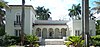 | December 1, 1988 (#88002690) | 2572 First Street 26°38′52″N 81°51′44″W / 26.647778°N 81.862222°W / 26.647778; -81.862222 (Alderman House) | Fort Myers | |
| 2 | Alva Consolidated Schools |  | June 10, 1999 (#99000695) | 21291 North River Road 26°42′58″N 81°36′36″W / 26.716111°N 81.61°W / 26.716111; -81.61 (Alva Consolidated Schools) | Alva | Part of the Lee County MPS |
| 3 | Boca Grande Community Center |  | March 30, 1995 (#95000306) | East of Park Avenue, between First and Second Streets 26°44′48″N 82°15′42″W / 26.746667°N 82.261667°W / 26.746667; -82.261667 (Boca Grande Community Center) | Boca Grande | Part of the Lee County MPS |
| 4 | Boca Grande Lighthouse |  | February 28, 1980 (#80000953) | South of Boca Grande on Gasparilla Island 26°44′29″N 82°15′49″W / 26.741389°N 82.263611°W / 26.741389; -82.263611 (Boca Grande Lighthouse) | Boca Grande | |
| 5 | Boca Grande Quarantine Station |  | March 22, 1996 (#96000447) | 833 Belcher Road 26°43′10″N 82°15′42″W / 26.719444°N 82.261667°W / 26.719444; -82.261667 (Boca Grande Quarantine Station) | Boca Grande | Part of the Lee County MPS |
| 6 | Bonita Springs School |  | July 8, 1999 (#99000800) | 10701 Dean Street 26°20′05″N 81°46′31″W / 26.334722°N 81.775278°W / 26.334722; -81.775278 (Bonita Springs School) | Bonita Springs | Part of the Lee County MPS |
| 7 | Buckingham School |  | February 17, 1989 (#89000011) | Buckingham and Cemetery Roads 26°40′18″N 81°43′57″W / 26.671667°N 81.7325°W / 26.671667; -81.7325 (Buckingham School) | Buckingham | |
| 8 | Cabbage Key Historic District | Upload image | November 12, 2015 (#15000784) | Intracoastal Waterway Marker 60 in Pine Island Sound 26°39′22″N 82°13′25″W / 26.6560°N 82.2236°W / 26.6560; -82.2236 (Cabbage Key Historic District) | Pineland | |
| 9 | Casa Rio |  | October 24, 1996 (#96001186) | 2424 McGregor Boulevard 26°38′00″N 81°52′53″W / 26.633333°N 81.881389°W / 26.633333; -81.881389 (Casa Rio) | Fort Myers | Part of the Lee County MPS |
| 10 | Captiva School and Chapel-by-the-Sea Historic District |  | October 23, 2013 (#13000853) | 11580 Chapin Ln. 26°31′14″N 82°11′34″W / 26.520687°N 82.192672°W / 26.520687; -82.192672 (Captiva School and Chapel-by-the-Sea Historic District) | Captiva | |
| 11 | Charlotte Harbor and Northern Railway Depot |  | December 13, 1979 (#79000676) | Park and 4th Streets 26°44′27″N 82°15′43″W / 26.740833°N 82.261944°W / 26.740833; -82.261944 (Charlotte Harbor and Northern Railway Depot) | Boca Grande | |
| 12 | Dean Park Historic Residential District |  | May 28, 2013 (#13000319) | Bounded by 1st St., Palm, Michigan & Evans Aves. 26°38′57″N 81°51′30″W / 26.649146°N 81.858444°W / 26.649146; -81.858444 (Dean Park Historic Residential District) | Fort Myers | |
| 13 | Demere Key | Upload image | June 13, 1972 (#72000332) | Off Pine Island[6] 26°35′35″N 82°08′01″W / 26.5931°N 82.1336°W / 26.5931; -82.1336 (Demere Key) | Pine Island | |
| 14 | Downtown Boca Grande Historic District |  | August 24, 2011 (#11000577) | Bounded by Gilchrist Avenue W., 5th Street N., Palm Avenue E., & 3rd Street S., 26°45′01″N 82°15′39″W / 26.750278°N 82.260833°W / 26.750278; -82.260833 (Downtown Boca Grande Historic District) | Boca Grande | |
| 15 | Paul Lawrence Dunbar School |  | February 24, 1992 (#92000025) | 1857 High Street 26°38′34″N 81°51′08″W / 26.642778°N 81.852222°W / 26.642778; -81.852222 (Paul Lawrence Dunbar School) | Fort Myers | |
| 16 | Edison Park Elementary School | 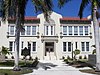 | May 5, 1999 (#99000524) | 2401 Euclid Avenue 26°37′57″N 81°52′30″W / 26.6325°N 81.875°W / 26.6325; -81.875 (Edison Park Elementary School) | Fort Myers | Part of the Lee County MPS |
| 17 | Thomas Edison Winter Estate |  | August 12, 1991 (#91001044) | 2350 McGregor Boulevard 26°38′03″N 81°52′51″W / 26.634199°N 81.880776°W / 26.634199; -81.880776 (Thomas Edison Winter Estate) | Fort Myers | |
| 18 | J. Colin English School |  | July 8, 1999 (#99000798) | 120 Pine Island Road 26°40′56″N 81°53′17″W / 26.682222°N 81.888056°W / 26.682222; -81.888056 (J. Colin English School) | North Fort Myers | Part of the Lee County MPS |
| 19 | First Baptist Church of Boca Grande |  | December 2, 2009 (#09000962) | 421 4th Street West 26°45′03″N 82°15′46″W / 26.750758°N 82.26275°W / 26.750758; -82.26275 (First Baptist Church of Boca Grande) | Boca Grande | |
| 20 | Fish Cabin at White Rock Shoals | 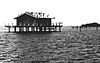 | April 11, 1991 (#91000398) | West of Pine Island in Pine Island Sound 26°32′41″N 82°07′19″W / 26.544722°N 82.121944°W / 26.544722; -82.121944 (Fish Cabin at White Rock Shoals) | St. James City | Part of the Fish Cabins of Charlotte Harbor MPS |
| 21 | Henry Ford Estate | 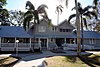 | September 8, 1988 (#88001822) | 2400 McGregor Boulevard 26°38′01″N 81°52′52″W / 26.633625°N 81.881221°W / 26.633625; -81.881221 (Henry Ford Estate) | Fort Myers | |
| 22 | Fort Myers Beach School |  | July 8, 1999 (#99000796) | 2751 Oak Street 26°26′54″N 81°56′20″W / 26.448333°N 81.938889°W / 26.448333; -81.938889 (Fort Myers Beach School) | Fort Myers Beach | Part of the Lee County MPS |
| 23 | Fort Myers Downtown Commercial District |  | January 26, 1990 (#89002325) | Roughly bounded by Bay and Lee Streets, Anderson Avenue, and Monroe Street 26°38′38″N 81°52′06″W / 26.643889°N 81.868333°W / 26.643889; -81.868333 (Fort Myers Downtown Commercial District) | Fort Myers | |
| 24 | Galt Island Archeological District | Upload image | May 21, 1996 (#96000531) | Address Restricted 26°30′58″N 82°06′23″W / 26.516111°N 82.106389°W / 26.516111; -82.106389 (Galt Island Archeological District) | St. James City | Part of the Archeological Resources of the Caloosahatchee Region MPS |
| 25 | Gasparilla Inn Historic District |  | March 18, 2008 (#08000205) | 500 Palm Avenue 26°45′08″N 82°15′39″W / 26.752222°N 82.260833°W / 26.752222; -82.260833 (Gasparilla Inn Historic District) | Boca Grande | |
| 26 | Gilmer Heitman House | 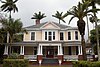 | September 27, 1996 (#96001033) | 2581 1st Street 26°38′55″N 81°51′46″W / 26.648611°N 81.862778°W / 26.648611; -81.862778 (Gilmer Heitman House) | Fort Myers | Part of the Lee County MPS |
| 27 | Hendrickson Fish Cabin at Captiva Rocks |  | April 11, 1991 (#91000402) | West of Little Wood Key in Pine Island Sound 26°37′42″N 82°11′29″W / 26.628333°N 82.191389°W / 26.628333; -82.191389 (Hendrickson Fish Cabin at Captiva Rocks) | Bokeelia | Part of the Fish Cabins of Charlotte Harbor MPS |
| 28 | Ice House at Captiva Rocks |  | April 11, 1991 (#91000407) | Southwest of Little Wood Key in Pine Island Sound 26°37′35″N 82°11′07″W / 26.626389°N 82.185278°W / 26.626389; -82.185278 (Ice House at Captiva Rocks) | Bokeelia | Part of the Fish Cabins of Charlotte Harbor MPS |
| 29 | Ice House at Point Blanco | 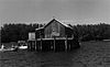 | April 11, 1991 (#91000408) | Southeast of Point Blanco Island in Pine Island Sound 26°40′30″N 82°13′31″W / 26.675°N 82.225278°W / 26.675; -82.225278 (Ice House at Point Blanco) | Bokeelia | Part of the Fish Cabins of Charlotte Harbor MPS |
| 30 | Jewett-Thompson House |  | September 29, 1988 (#88001708) | 1141 Wales Drive 26°36′33″N 81°53′28″W / 26.609167°N 81.891111°W / 26.609167; -81.891111 (Jewett-Thompson House) | Fort Myers | |
| 31 | Josslyn Island Site | Upload image | December 14, 1978 (#78000948) | Address Restricted 26°37′31″N 82°09′09″W / 26.625278°N 82.1525°W / 26.625278; -82.1525 (Josslyn Island Site) | Pineland | Part of the Archeological Resources of the Caloosahatchee Region MPS |
| 32 | Journey's End |  | March 14, 1985 (#85000554) | Beachfront at 18th Street 26°45′44″N 82°15′57″W / 26.762222°N 82.265833°W / 26.762222; -82.265833 (Journey's End) | Boca Grande | |
| 33 | Koreshan Unity Settlement Historic District |  | May 4, 1976 (#76000599) | U.S. Route 41 at the Estero River 26°26′02″N 81°48′43″W / 26.433889°N 81.811944°W / 26.433889; -81.811944 (Koreshan Unity Settlement Historic District) | Estero | |
| 34 | Larsen Fish Cabin at Captiva Rocks |  | April 11, 1991 (#91000404) | West of Little Wood Key in Pine Island Sound 26°37′46″N 82°11′29″W / 26.629444°N 82.191389°W / 26.629444; -82.191389 (Larsen Fish Cabin at Captiva Rocks) | Bokeelia | Part of the Fish Cabins of Charlotte Harbor MPS |
| 35 | Lee County Courthouse |  | March 16, 1989 (#89000196) | 2120 Main Street 26°38′31″N 81°52′14″W / 26.641944°N 81.870556°W / 26.641944; -81.870556 (Lee County Courthouse) | Fort Myers | |
| 36 | Leneer Fish Cabin at Captiva Rocks | 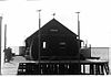 | April 11, 1991 (#91000403) | West of Little Wood Key in Pine Island Sound 26°37′38″N 82°11′25″W / 26.627222°N 82.190278°W / 26.627222; -82.190278 (Leneer Fish Cabin at Captiva Rocks) | Bokeelia | Part of the Fish Cabins of Charlotte Harbor MPS |
| 37 | Halstead and Emily Lindsley House |  | August 4, 2011 (#11000502) | 1300 West 13th Street 26°45′31″N 82°15′53″W / 26.758611°N 82.264722°W / 26.758611; -82.264722 (Halstead and Emily Lindsley House) | Boca Grande | |
| 38 | Menge-Hansen Marine Ways |  | September 2, 2009 (#09000670) | 5605 Palm Beach Boulevard 26°41′16″N 81°47′35″W / 26.687778°N 81.793056°W / 26.687778; -81.793056 (Menge-Hansen Marine Ways) | Fort Myers | |
| 39 | McCollum Hall |  | April 18, 2022 (#100007618) | 2701 Dr. Martin Luther King, Jr. Blvd 26°38′28″N 81°51′28″W / 26.641048°N 81.857818°W / 26.641048; -81.857818 (McCollum Hall) | Fort Myers | |
| 40 | Mound House | 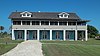 | March 22, 2019 (#100002723) | 451 Connecticut St. 26°26′46″N 81°55′40″W / 26.4461°N 81.9279°W / 26.4461; -81.9279 (Mound House) | Fort Myers Beach | |
| 41 | Mound Key Site | Upload image | August 12, 1970 (#70000187) | Address Restricted 26°25′20″N 81°51′55″W / 26.422222°N 81.865278°W / 26.422222; -81.865278 (Mound Key Site) | Fort Myers Beach | Part of the Archeological Resources of the Caloosahatchee Region MPS |
| 42 | Murphy-Burroughs House |  | August 1, 1984 (#84000898) | 2505 1st Street 26°38′49″N 81°51′57″W / 26.646944°N 81.865833°W / 26.646944; -81.865833 (Murphy-Burroughs House) | Fort Myers | |
| 43 | Norton Fish Cabin at Captiva Rocks |  | April 11, 1991 (#91000405) | West of Little Wood Key in Pine Island Sound 26°37′47″N 82°11′32″W / 26.629722°N 82.192222°W / 26.629722; -82.192222 (Norton Fish Cabin at Captiva Rocks) | Bokeelia | Part of the Fish Cabins of Charlotte Harbor MPS |
| 44 | Olga School |  | April 27, 1995 (#95000509) | South Olga Road 26°43′03″N 81°42′47″W / 26.7175°N 81.713056°W / 26.7175; -81.713056 (Olga School) | Olga | Part of the Lee County MPS |
| 45 | Mark Pardo Shellworks Site | Upload image | May 21, 1996 (#96000533) | Address Restricted | Bokeelia | Part of the Archeological Resources of the Caloosahatchee Region MPS |
| 46 | Pine--Aire Lodge | Upload image | October 8, 2014 (#14000826) | 13771 Waterfront Dr. 26°39′41″N 82°09′16″W / 26.661342°N 82.154357°W / 26.661342; -82.154357 (Pine--Aire Lodge) | Bokeelia | |
| 47 | Pineland Archeological District | Upload image | November 27, 1973 (#73000583) | Address Restricted | Pineland | Part of the Archeological Resources of the Caloosahatchee Region MPS |
| 48 | Punta Gorda Fish Company Cabin |  | December 18, 2003 (#03001289) | Pine Island Sound 26°37′41″N 82°11′26″W / 26.628056°N 82.190556°W / 26.628056; -82.190556 (Punta Gorda Fish Company Cabin) | Bokeelia | Part of the Fish Cabins of Charlotte Harbor MPS |
| 49 | Punta Gorda Fish Company Ice House |  | April 20, 1989 (#89000320) | Northern shore of the entrance to Safety Harbor 26°35′56″N 82°12′49″W / 26.598889°N 82.213611°W / 26.598889; -82.213611 (Punta Gorda Fish Company Ice House) | North Captiva Island | |
| 50 | Sanibel Colored School |  | July 8, 1999 (#99000797) | 520 Tarpon Bay Road 26°26′21″N 82°03′53″W / 26.439167°N 82.064722°W / 26.439167; -82.064722 (Sanibel Colored School) | Sanibel | Part of the Lee County MPS |
| 51 | Sanibel Lighthouse and Keeper's Quarters |  | October 1, 1974 (#74000648) | Point Ybel on Sanibel Island 26°27′10″N 82°00′51″W / 26.452778°N 82.014167°W / 26.452778; -82.014167 (Sanibel Lighthouse and Keeper's Quarters) | Sanibel | |
| 52 | Terry Park Ballfield |  | June 20, 1995 (#95000730) | 3410 Palm Beach Boulevard 26°39′25″N 81°50′31″W / 26.656944°N 81.841944°W / 26.656944; -81.841944 (Terry Park Ballfield) | Fort Myers | Part of the Lee County MPS |
| 53 | Tice Grammar School |  | July 8, 1999 (#99000799) | 4524 Tice Street 26°40′12″N 81°49′15″W / 26.67°N 81.820833°W / 26.67; -81.820833 (Tice Grammar School) | Tice | Part of the Lee County MPS |
| 54 | William H. Towles House | 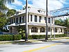 | May 29, 2008 (#08000463) | 2050 McGregor Boulevard 26°38′22″N 81°52′28″W / 26.639444°N 81.874333°W / 26.639444; -81.874333 (William H. Towles House) | Fort Myers | |
| 55 | Tween Waters Inn Historic District | 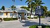 | December 15, 2011 (#11000904) | 15951 Captiva Drive 26°30′37″N 82°11′25″W / 26.510269°N 82.190287°W / 26.510269; -82.190287 (Tween Waters Inn Historic District) | Captiva | Part of the Lee County MPS |
| 56 | Useppa Island Site | Upload image | May 21, 1996 (#96000532) | Address Restricted | Bokeelia | Part of the Archeological Resources of the Caloosahatchee Region MPS |
| 57 | Whidden Fish Cabin at Captiva Rocks | Upload image | April 11, 1991 (#91000406) | West of Little Wood Key in Pine Island Sound 26°37′35″N 82°11′24″W / 26.626389°N 82.19°W / 26.626389; -82.19 (Whidden Fish Cabin at Captiva Rocks) | Bokeelia | Part of the Fish Cabins of Charlotte Harbor MPS |
| 58 | Whidden's Marina |  | December 28, 2000 (#00001539) | 190 First Street East 26°44′44″N 82°15′26″W / 26.745556°N 82.257222°W / 26.745556; -82.257222 (Whidden's Marina) | Boca Grande | Part of the Lee County MPS |
See also
Wikimedia Commons has media related to National Register of Historic Places in Lee County, Florida.
- List of National Historic Landmarks in Florida
- National Register of Historic Places listings in Florida
References
- ^ The latitude and longitude information provided in this table was derived originally from the National Register Information System, which has been found to be fairly accurate for about 99% of listings. Some locations in this table may have been corrected to current GPS standards.
- ^ National Park Service, United States Department of the Interior, "National Register of Historic Places: Weekly List Actions", retrieved June 7, 2024.
- ^ Numbers represent an alphabetical ordering by significant words. Various colorings, defined here, differentiate National Historic Landmarks and historic districts from other NRHP buildings, structures, sites or objects.
- ^ "National Register Information System". National Register of Historic Places. National Park Service. March 13, 2009.
- ^ The eight-digit number below each date is the number assigned to each location in the National Register Information System database, which can be viewed by clicking the number.
- ^ Location derived from its GNIS feature record; the NRIS lists the site as "Address Restricted"
- v
- t
- e
by county
- Alachua
- Baker
- Bay
- Bradford
- Brevard
- Broward
- Calhoun
- Charlotte
- Citrus
- Clay
- Collier
- Columbia
- DeSoto
- Dixie
- Duval
- Escambia
- Flagler
- Franklin
- Gadsden
- Gilchrist
- Glades
- Gulf
- Hamilton
- Hardee
- Hendry
- Hernando
- Highlands
- Hillsborough
- Holmes
- Indian River
- Jackson
- Jefferson
- Lake
- Lee
- Leon
- Levy
- Liberty
- Madison
- Manatee
- Marion
- Martin
- Miami-Dade
- Monroe
- Nassau
- Okaloosa
- Okeechobee
- Orange
- Osceola
- Palm Beach
- Pasco
- Pinellas
- Polk
- Putnam
- Santa Rosa
- Sarasota
- Seminole
- St. Johns
- St. Lucie
- Sumter
- Suwannee
- Taylor
- Union
- Volusia
- Wakulla
- Walton
- Washington

Municipalities and communities of Lee County, Florida, United States | ||
|---|---|---|
County seat: Fort Myers | ||
| Cities |  | |
| Town | ||
| Village | ||
| CDPs |
| |
| Unincorporated community | ||
| ||


