National Register of Historic Places listings in Pasadena, California

Map all coordinates using OpenStreetMap
Download coordinates as:
- KML
- GPX (all coordinates)
- GPX (primary coordinates)
- GPX (secondary coordinates)
This is intended to be a complete list of the properties and districts on the National Register of Historic Places in the city of Pasadena, California, United States. The locations of National Register properties and districts for which the latitude and longitude coordinates are included below, may be seen in an online map.[1]
There are more than 500 properties and districts listed on the National Register in the county, including 21 National Historic Landmarks. Pasadena is the location of 129 of these properties and districts, including 5 National Historic Landmarks; they are listed here.[2] The other properties and districts elsewhere in the county, including 5 National Historic Landmarks, are listed separately. A single district, the Arroyo Seco Parkway Historic District, is split between Pasadena and other parts of the county.

The first sites in Pasadena to be listed on the Register were Greene and Greene's American Craftsman masterpiece, the Gamble House (built from 1908 to 1909), the Pasadena Playhouse (built in 1924) and Frank Lloyd Wright's textile block structure, the Millard House (built in 1923). Greene and Greene also built the Robert R. Blacker House, Dr. W. T. Bolton House and Cordelia A. Culbertson House, all examples of their innovative Craftsman-style bungalow houses and larger-scale ultimate bungalows. Other architects of note who have designed buildings in Pasadena include Myron Hunt (the Rose Bowl and California Institute of Technology) and Welton Beckett (Bullock's Pasadena).
Pasadena is the home of many leading scientific and cultural institutions, including the California Institute of Technology (Caltech), the Jet Propulsion Laboratory, the Pasadena Playhouse and the Norton Simon Museum of Art. Several sites relate to Pasadena's long connection with astronomy and space exploration, including the Space Flight Operations Facility, the Twenty-Five-Foot Space Simulator, and Hale Solar Laboratory. Also, the Edwin Hubble House, home to famed astronomer Edwin Hubble, is located in the adjacent community of San Marino.
Two of Pasadena's historic bridges, the Colorado Street Bridge, built in 1913 and known for its distinctive Beaux Arts arches, light standards, and railings, and the La Loma Bridge, built in 1914, are among the sites listed on the Register.
Thirty-one of Pasadena's listings are historic districts, which include multiple contributing properties. Among these historic districts is Old Town Pasadena, a thriving historic district of shops, bars and restaurants in well-preserved turn-of-the-century buildings with its center at Fair Oaks Avenue and Colorado Boulevard. Other historic districts include the Pasadena Playhouse Historic District, the Pasadena Civic Center District, the Bungalow Heaven Landmark District, the Civic Center Financial District, the Lower Arroyo Seco Historic District, the Orange Heights-Barnhart Tracts Historic District, the Park Place-Arroyo Terrace Historic District, the Prospect Historic District and the South Marengo Historic District.
This National Park Service list is complete through NPS recent listings posted June 7, 2024.[3]
Map all coordinates using OpenStreetMap
Download coordinates as:
- KML
- GPX (all coordinates)
- GPX (primary coordinates)
- GPX (secondary coordinates)
Current listings
| [4] | Name on the Register[5] | Image | Date listed[6] | Location | Description |
|---|---|---|---|---|---|
| 1 | Arroyo Seco Parkway Historic District | 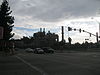 | February 4, 2011 (#10001198) | CA 110 from Four Level Interchange in Los Angeles to East Glenarm St. in Pasadena 34°07′39″N 118°08′50″W / 34.1275°N 118.147222°W / 34.1275; -118.147222 (Arroyo Seco Parkway Historic District) | Runs from Downtown Los Angeles to Pasadena |
| 2 | Batchelder House |  | December 14, 1978 (#78000695) | 626 S. Arroyo Blvd. 34°08′06″N 118°09′54″W / 34.135°N 118.165°W / 34.135; -118.165 (Batchelder House) | |
| 3 | Bekins Storage Co. Roof Sign |  | October 15, 1997 (#97001212) | 511 S. Fair Oaks Ave. 34°08′14″N 118°09′00″W / 34.137222°N 118.15°W / 34.137222; -118.15 (Bekins Storage Co. Roof Sign) | A rooftop sign, which now promotes Public Storage Co. |
| 4 | Louise C. Bentz House |  | December 2, 1977 (#77000299) | 657 Prospect Blvd. 34°09′21″N 118°09′38″W / 34.155833°N 118.160556°W / 34.155833; -118.160556 (Louise C. Bentz House) | |
| 5 | Robert R. Blacker House |  | February 6, 1986 (#86000147) | 1177 Hillcrest Ave. 34°07′37″N 118°07′58″W / 34.126944°N 118.132778°W / 34.126944; -118.132778 (Robert R. Blacker House) | |
| 6 | Edmund Blinn House |  | April 5, 2001 (#01000329) | 160 N. Oakland Ave. 34°08′55″N 118°08′19″W / 34.148611°N 118.138611°W / 34.148611; -118.138611 (Edmund Blinn House) | |
| 7 | Dr. W. T. Bolton House | 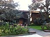 | July 9, 1980 (#80004491) | 370 W. Del Mar Blvd. 34°08′26″N 118°09′27″W / 34.140556°N 118.1575°W / 34.140556; -118.1575 (Dr. W. T. Bolton House) | |
| 8 | Bonnie Court |  | November 15, 1994 (#94001325) | 140 S. Bonnie Ave. 34°08′35″N 118°06′52″W / 34.143056°N 118.114444°W / 34.143056; -118.114444 (Bonnie Court) | |
| 9 | Bowen Court |  | June 17, 1982 (#82002194) | 539 E. Villa St. 34°09′20″N 118°08′18″W / 34.155556°N 118.138333°W / 34.155556; -118.138333 (Bowen Court) | |
| 10 | Bristol-Cypress Historic District |  | August 9, 2011 (#11000489) | 438-516 Cypress Ave. 34°09′13″N 118°09′15″W / 34.153611°N 118.154167°W / 34.153611; -118.154167 (Bristol-Cypress Historic District) | |
| 11 | Bryan Court |  | April 16, 1986 (#86000790) | 427 S. Marengo Ave. 34°08′18″N 118°08′46″W / 34.138333°N 118.146111°W / 34.138333; -118.146111 (Bryan Court) | |
| 12 | Bullock's Pasadena |  | July 12, 1996 (#96000776) | 401 S. Lake Ave. 34°08′15″N 118°07′58″W / 34.1375°N 118.132778°W / 34.1375; -118.132778 (Bullock's Pasadena) | |
| 13 | Bungalow Heaven Historic District |  | April 10, 2008 (#08000260) | Roughly bounded by N. Mentor Ave., E. Orange Grove Blvd., E. Washington Blvd., N. Michigan & N. Chester Aves. 34°09′48″N 118°07′39″W / 34.163403°N 118.127469°W / 34.163403; -118.127469 (Bungalow Heaven Historic District) | |
| 14 | Case Study House No. 10 |  | July 24, 2013 (#13000514) | 711 S. San Rafael Ave. 34°07′52″N 118°10′13″W / 34.13122°N 118.17032°W / 34.13122; -118.17032 (Case Study House No. 10) | One of the Case Study Houses. While the NPS listing for the property gives its address as in Los Angeles, its nomination form places the property in Pasadena.[7] |
| 15 | Civic Center Financial District | 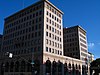 | October 29, 1982 (#82000967) | E. Colorado Blvd. and Marengo Ave. 34°08′46″N 118°08′41″W / 34.146111°N 118.144722°W / 34.146111; -118.144722 (Civic Center Financial District) | |
| 16 | Colonial Court |  | July 11, 1983 (#83001185) | 291-301 N. Garfield Ave. 34°09′04″N 118°08′39″W / 34.151111°N 118.144167°W / 34.151111; -118.144167 (Colonial Court) | |
| 17 | Colorado Street Bridge |  | February 12, 1981 (#81000156) | Colorado Blvd. 34°08′41″N 118°09′49″W / 34.144722°N 118.163611°W / 34.144722; -118.163611 (Colorado Street Bridge) | |
| 18 | James Fielding Cosby House |  | August 9, 2011 (#11000490) | 510 Locke Haven St. 34°08′17″N 118°09′41″W / 34.138056°N 118.161389°W / 34.138056; -118.161389 (James Fielding Cosby House) | |
| 19 | Cottage Court |  | July 11, 1983 (#83001186) | 642-654 S. Marengo Ave. 34°08′04″N 118°08′41″W / 34.134444°N 118.144722°W / 34.134444; -118.144722 (Cottage Court) | |
| 20 | Court |  | July 11, 1983 (#83001188) | 744-756½ S. Marengo Ave. 34°07′58″N 118°08′40″W / 34.132778°N 118.144444°W / 34.132778; -118.144444 (Court) | |
| 21 | Court | 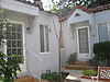 | July 11, 1983 (#83001187) | 497-503½ N. Madison Ave. 34°09′17″N 118°08′15″W / 34.154722°N 118.1375°W / 34.154722; -118.1375 (Court) | |
| 22 | Court |  | July 11, 1983 (#83001189) | 732–744 Santa Barbara St. 34°09′19″N 118°08′03″W / 34.155278°N 118.134167°W / 34.155278; -118.134167 (Court) | |
| 23 | Court at 1274-1282 North Raymond Avenue |  | November 15, 1994 (#94001315) | 1274-1282 N. Raymond Ave. 34°10′04″N 118°08′56″W / 34.167821°N 118.14875°W / 34.167821; -118.14875 (Court at 1274-1282 North Raymond Avenue) | |
| 24 | Court at 275 North Chester Avenue |  | November 15, 1994 (#94001324) | 275 N. Chester Ave. 34°09′03″N 118°07′29″W / 34.150951°N 118.124615°W / 34.150951; -118.124615 (Court at 275 North Chester Avenue) | |
| 25 | Court at 533-549 North Lincoln Avenue |  | November 15, 1994 (#94001320) | 533-549 N. Lincoln Ave. 34°09′15″N 118°09′14″W / 34.154231°N 118.153963°W / 34.154231; -118.153963 (Court at 533-549 North Lincoln Avenue) | |
| 26 | Court at 638-650 North Mar Vista Avenue |  | November 15, 1994 (#94001319) | 638-650 N. Mar Vista Ave. 34°09′26″N 118°07′35″W / 34.157131°N 118.126482°W / 34.157131; -118.126482 (Court at 638-650 North Mar Vista Avenue) | |
| 27 | Court at 940-948 North Raymond Avenue |  | November 15, 1994 (#94001317) | 940-948 N. Raymond Ave. 34°09′43″N 118°08′55″W / 34.162058°N 118.148689°W / 34.162058; -118.148689 (Court at 940-948 North Raymond Avenue) | |
| 28 | Cordelia A. Culbertson House |  | September 12, 1985 (#85002198) | 1188 Hillcrest Ave. 34°07′40″N 118°07′56″W / 34.127778°N 118.132222°W / 34.127778; -118.132222 (Cordelia A. Culbertson House) | |
| 29 | Cypress Court |  | July 11, 1983 (#83001190) | 623-641 N. Madison Ave. 34°09′25″N 118°08′16″W / 34.156944°N 118.137778°W / 34.156944; -118.137778 (Cypress Court) | |
| 30 | Mary E. Denham House |  | August 9, 2011 (#11000491) | 297 S. Orange Grove Blvd. 34°08′26″N 118°09′35″W / 34.140556°N 118.159722°W / 34.140556; -118.159722 (Mary E. Denham House) | |
| 31 | Don Carlos Court |  | July 11, 1983 (#83001191) | 374-386 S. Marengo Ave. 34°08′23″N 118°08′40″W / 34.139722°N 118.144444°W / 34.139722; -118.144444 (Don Carlos Court) | |
| 32 | Euclid Court |  | July 11, 1983 (#83001193) | 545 S. Euclid Ave. 34°08′11″N 118°08′32″W / 34.136389°N 118.142222°W / 34.136389; -118.142222 (Euclid Court) | |
| 33 | Evanston Inn |  | September 13, 1984 (#84000787) | 385-395 S. Marengo Ave. 34°08′19″N 118°08′43″W / 34.138611°N 118.145278°W / 34.138611; -118.145278 (Evanston Inn) | |
| 34 | Fenyes Estate |  | September 5, 1985 (#85001983) | 470 W. Walnut St. & 160 N. Orange Grove Blvd. 34°08′56″N 118°09′37″W / 34.148889°N 118.160278°W / 34.148889; -118.160278 (Fenyes Estate) | |
| 35 | First Trust Building and Garage | 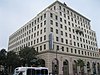 | June 12, 1987 (#87000941) | 587-611 E. Colorado Blvd. and 30-44 N. Madison Ave. 34°08′46″N 118°08′17″W / 34.14613°N 118.13808°W / 34.14613; -118.13808 (First Trust Building and Garage) | |
| 36 | Foothill Boulevard Milestone (Mile 11) | 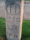 | April 19, 1996 (#96000421) | South side of E. Colorado Blvd., west of the junction with Holliston Ave. 34°08′45″N 118°07′23″W / 34.145864°N 118.123156°W / 34.145864; -118.123156 (Foothill Boulevard Milestone (Mile 11)) | |
| 37 | Ford Place Historic District |  | July 22, 2010 (#10000496) | 110-175 N. Oakland Ave.; 450-465 Ford Place; 144 N. Los Robles Ave. 34°08′55″N 118°08′26″W / 34.148611°N 118.140556°W / 34.148611; -118.140556 (Ford Place Historic District) | |
| 38 | Richard and Mary Alice Frank House |  | April 10, 2009 (#09000175) | 919 La Loma Road 34°08′05″N 118°10′10″W / 34.134722°N 118.169444°W / 34.134722; -118.169444 (Richard and Mary Alice Frank House) | |
| 39 | Rose Graham and James Allen Freeman House |  | September 15, 2011 (#11000654) | 1330 Hillcrest Ave. 34°07′28″N 118°07′53″W / 34.124577°N 118.131510°W / 34.124577; -118.131510 (Rose Graham and James Allen Freeman House) | |
| 40 | Friendship Baptist Church | 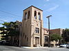 | November 20, 1978 (#78000696) | 80 W. Dayton St. 34°08′36″N 118°09′04″W / 34.143333°N 118.151111°W / 34.143333; -118.151111 (Friendship Baptist Church) | |
| 41 | Gamble House |  | September 3, 1971 (#71000155) | 4 Westmoreland Pl. 34°09′05″N 118°09′36″W / 34.151389°N 118.16°W / 34.151389; -118.16 (Gamble House) | |
| 42 | Gartz Court |  | August 25, 1983 (#83001195) | 745 N. Pasadena Ave. 34°09′26″N 118°09′36″W / 34.157095°N 118.160128°W / 34.157095; -118.160128 (Gartz Court) | |
| 43 | Merwyn C. Gill House |  | December 23, 2009 (#09000176) | 1385 El Mirador Dr. 34°09′56″N 118°10′44″W / 34.165604°N 118.178942°W / 34.165604; -118.178942 (Merwyn C. Gill House) | |
| 44 | Hale Solar Laboratory |  | January 23, 1986 (#86000103) | 740 Holladay Rd. 34°07′59″N 118°07′14″W / 34.133056°N 118.120556°W / 34.133056; -118.120556 (Hale Solar Laboratory) | |
| 45 | Harnetiaux Court |  | November 15, 1994 (#94001321) | 48 N. Catalina Ave. 34°08′49″N 118°07′45″W / 34.146902°N 118.129131°W / 34.146902; -118.129131 (Harnetiaux Court) | |
| 46 | John S. Hartwell House |  | August 9, 2011 (#11000492) | 423 Lincoln Ave. 34°09′09″N 118°09′10″W / 34.1525°N 118.152778°W / 34.1525; -118.152778 (John S. Hartwell House) | |
| 47 | Haskett Court | 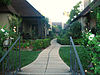 | February 25, 1982 (#82002195) | 824-834 E. California Blvd. 34°08′09″N 118°07′56″W / 34.135833°N 118.132222°W / 34.135833; -118.132222 (Haskett Court) | |
| 48 | Hermitage |  | April 5, 2001 (#01000328) | 2121 Monte Vista St. 34°09′20″N 118°06′25″W / 34.15563°N 118.106816°W / 34.15563; -118.106816 (Hermitage) | |
| 49 | Hillmont | 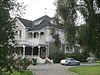 | August 9, 2011 (#11000493) | 1375 E. Mountain St. 34°09′43″N 118°07′19″W / 34.161944°N 118.121944°W / 34.161944; -118.121944 (Hillmont) | |
| 50 | Holly Street Livery Stable |  | October 25, 1979 (#79000491) | 110 E. Holly St 34°08′49″N 118°08′51″W / 34.146944°N 118.1475°W / 34.146944; -118.1475 (Holly Street Livery Stable) | |
| 51 | Home Laundry |  | June 18, 1987 (#87000980) | 432 S. Arroyo Pkwy. 34°08′18″N 118°08′49″W / 34.138462°N 118.147045°W / 34.138462; -118.147045 (Home Laundry) | |
| 52 | Mrs. J.H. Hood House |  | August 9, 2011 (#11000494) | 494 Ellis St. 34°08′27″N 118°09′39″W / 34.140833°N 118.160833°W / 34.140833; -118.160833 (Mrs. J.H. Hood House) | |
| 53 | Hotel Green |  | March 23, 1982 (#82002196) | 99 S. Raymond Ave. 34°08′39″N 118°08′55″W / 34.144167°N 118.148611°W / 34.144167; -118.148611 (Hotel Green) | |
| 54 | House at 1011 S. Madison Ave. |  | August 6, 1998 (#98000959) | 1011 S. Madison Ave. 34°07′43″N 118°08′19″W / 34.128476°N 118.13856°W / 34.128476; -118.13856 (House at 1011 S. Madison Ave.) | |
| 55 | House at 1015 Prospect Boulevard |  | August 20, 2004 (#04000322) | 1015 Prospect Blvd. 34°09′37″N 118°09′46″W / 34.160403°N 118.162777°W / 34.160403; -118.162777 (House at 1015 Prospect Boulevard) | |
| 56 | House at 1050 S. Madison Ave. |  | August 6, 1998 (#98000960) | 1050 S. Madison Ave. 34°07′40″N 118°08′17″W / 34.127867°N 118.137961°W / 34.127867; -118.137961 (House at 1050 S. Madison Ave.) | |
| 57 | House at 1111 North Los Robles Avenue |  | December 3, 2013 (#13000868) | 1111 N. Los Robles Ave. 34°09′54″N 118°08′31″W / 34.165023°N 118.1419°W / 34.165023; -118.1419 (House at 1111 North Los Robles Avenue) | |
| 58 | House at 1121 North Los Robles Avenue |  | December 3, 2013 (#13000869) | 1121-1123 N. Los Robles Ave. 34°09′55″N 118°08′31″W / 34.165192°N 118.141921°W / 34.165192; -118.141921 (House at 1121 North Los Robles Avenue) | |
| 59 | House at 1141 North Chester Avenue |  | August 20, 2004 (#04000326) | 1141 N. Chester Ave. 34°09′57″N 118°07′29″W / 34.165742°N 118.124798°W / 34.165742; -118.124798 (House at 1141 North Chester Avenue) | |
| 60 | House at 1233 Wentworth Ave. |  | August 6, 1998 (#98000962) | 1233 Wentworth Ave. 34°07′32″N 118°08′03″W / 34.125492°N 118.13425°W / 34.125492; -118.13425 (House at 1233 Wentworth Ave.) | |
| 61 | House at 1240 North Los Robles |  | August 20, 2004 (#04000329) | 1240 N. Los Robles Ave. 34°10′02″N 118°08′29″W / 34.167216°N 118.141265°W / 34.167216; -118.141265 (House at 1240 North Los Robles) | |
| 62 | House at 1360 Lida Street |  | August 9, 2011 (#11000495) | 1360 Lida St. 34°10′17″N 118°10′46″W / 34.171319°N 118.17932°W / 34.171319; -118.17932 (House at 1360 Lida Street) | |
| 63 | House at 1487 Loma Vista Street |  | August 20, 2004 (#04000323) | 1487 Loma Vista St. 34°09′38″N 118°07′11″W / 34.160602°N 118.119809°W / 34.160602; -118.119809 (House at 1487 Loma Vista Street) | |
| 64 | House at 380 W. Del Mar Blvd. |  | August 6, 1998 (#98000961) | 380 W. Del Mar Blvd. 34°08′26″N 118°09′30″W / 34.140554°N 118.158463°W / 34.140554; -118.158463 (House at 380 W. Del Mar Blvd.) | |
| 65 | House at 530 S. Marengo Avenue |  | September 13, 1979 (#79000492) | 530 S. Marengo Ave. 34°08′12″N 118°08′44″W / 34.136667°N 118.145503°W / 34.136667; -118.145503 (House at 530 S. Marengo Avenue) | |
| 66 | House at 574 Bellefontaine St. |  | August 6, 1998 (#98000958) | 574 Bellefontaine St. 34°07′53″N 118°09′45″W / 34.131469°N 118.16252°W / 34.131469; -118.16252 (House at 574 Bellefontaine St.) | |
| 67 | House at 674 Elliot Drive |  | August 20, 2004 (#04000325) | 674 Elliot Dr. 34°07′31″N 118°08′10″W / 34.125278°N 118.136111°W / 34.125278; -118.136111 (House at 674 Elliot Drive) | |
| 68 | Howard Motor Company Building |  | April 18, 1996 (#96000422) | 1285 E. Colorado Blvd. 34°08′47″N 118°07′26″W / 34.146269°N 118.123828°W / 34.146269; -118.123828 (Howard Motor Company Building) | |
| 69 | Benjamin Jarvis House |  | August 9, 2011 (#11000496) | 531 N. Raymond Ave. 34°09′18″N 118°08′58″W / 34.155°N 118.149444°W / 34.155; -118.149444 (Benjamin Jarvis House) | |
| 70 | Kindel Building |  | April 18, 1996 (#96000423) | 1095 E. Colorado Blvd. 34°08′47″N 118°07′40″W / 34.146292°N 118.127769°W / 34.146292; -118.127769 (Kindel Building) | |
| 71 | Kosy Knook Court |  | November 15, 1994 (#94001322) | 830 Brooks Ave. 34°09′35″N 118°09′19″W / 34.159679°N 118.15532°W / 34.159679; -118.15532 (Kosy Knook Court) | |
| 72 | La Loma Bridge |  | July 14, 2004 (#04000680) | Crossing the Arroyo Seco at La Loma Road 34°08′03″N 118°10′01″W / 34.134178°N 118.166919°W / 34.134178; -118.166919 (La Loma Bridge) | |
| 73 | Friend Lacey House |  | August 9, 2011 (#11000497) | 679 E. Villa St. 34°09′16″N 118°08′11″W / 34.154444°N 118.136389°W / 34.154444; -118.136389 (Friend Lacey House) | |
| 74 | Las Casitas Court |  | July 11, 1983 (#83001196) | 656 N. Summit Ave. 34°09′26″N 118°08′51″W / 34.157102°N 118.147563°W / 34.157102; -118.147563 (Las Casitas Court) | |
| 75 | Longfellow-Hastings House |  | March 2, 1982 (#82002197) | 85 S. Allen Ave. 34°08′40″N 118°06′45″W / 34.144444°N 118.1125°W / 34.144444; -118.1125 (Longfellow-Hastings House) | |
| 76 | Lower Arroyo Seco Historic District |  | July 12, 2005 (#04000331) | Roughly Arroyo Blvd., W. California Blvd., La Loma Blvd. 34°08′06″N 118°09′59″W / 34.135114°N 118.166281°W / 34.135114; -118.166281 (Lower Arroyo Seco Historic District) | |
| 77 | Theodore Parker Lukens House |  | March 29, 1984 (#84000879) | 267 N. El Molino Ave. 34°09′02″N 118°08′15″W / 34.150498°N 118.137436°W / 34.150498; -118.137436 (Theodore Parker Lukens House) | |
| 78 | W. Parker Lyon House |  | April 23, 2020 (#100005212) | 280 California Terrace 34°08′28″N 118°09′51″W / 34.1412°N 118.1641°W / 34.1412; -118.1641 (W. Parker Lyon House) | |
| 79 | Marengo Gardens |  | July 11, 1983 (#83001197) | 982, 986, 990 S. Marengo Ave. and 221-241 Ohio St. 34°07′58″N 118°08′40″W / 34.132778°N 118.144444°W / 34.132778; -118.144444 (Marengo Gardens) | |
| 80 | Marguerita Lane Historic District |  | April 10, 2009 (#09000177) | Marguerita Lane off South Marengo Avenue 34°07′26″N 118°08′41″W / 34.123889°N 118.144722°W / 34.123889; -118.144722 (Marguerita Lane Historic District) | |
| 81 | Markham Place Historic District |  | March 27, 2013 (#13000106) | Roughly bounded by California St., Pasadena Ave., Bellefontaine St. & Orange Grove Blvd. 34°08′02″N 118°09′22″W / 34.133885°N 118.156246°W / 34.133885; -118.156246 (Markham Place Historic District) | |
| 82 | Mary Louise Court |  | November 15, 1994 (#94001318) | 583-599 N. Mentor Ave. 34°09′22″N 118°07′53″W / 34.15619°N 118.131321°W / 34.15619; -118.131321 (Mary Louise Court) | |
| 83 | Clarence and Mary Mello House |  | April 10, 2009 (#09000178) | 541 Fremont Dr. 34°09′16″N 118°09′45″W / 34.154381°N 118.162439°W / 34.154381; -118.162439 (Clarence and Mary Mello House) | |
| 84 | Mentor Court |  | November 15, 1994 (#94001323) | 937 E. California Blvd. 34°08′10″N 118°07′49″W / 34.136111°N 118.130278°W / 34.136111; -118.130278 (Mentor Court) | |
| 85 | Samuel Merrill House |  | April 5, 2001 (#01000330) | 1285 N. Summit Ave. 34°10′05″N 118°08′53″W / 34.167987°N 118.147992°W / 34.167987; -118.147992 (Samuel Merrill House) | |
| 86 | Merwin House |  | January 14, 2013 (#12001164) | 267 W. State St. 34°07′34″N 118°09′21″W / 34.126123°N 118.155946°W / 34.126123; -118.155946 (Merwin House) | |
| 87 | Millard House |  | December 12, 1976 (#76000493) | 645 Prospect Crescent 34°09′19″N 118°09′39″W / 34.155278°N 118.160833°W / 34.155278; -118.160833 (Millard House) | Textile block house designed by Frank Lloyd Wright |
| 88 | Miss Orton's Classical School for Girls (Dormitory) |  | August 4, 1995 (#95000998) | 154 S. Euclid Ave. 34°08′36″N 118°08′33″W / 34.143253°N 118.142618°W / 34.143253; -118.142618 (Miss Orton's Classical School for Girls (Dormitory)) | |
| 89 | Mission Court |  | July 11, 1983 (#83001198) | 567 N. Oakland Ave. 34°09′21″N 118°08′22″W / 34.155833°N 118.139444°W / 34.155833; -118.139444 (Mission Court) | |
| 90 | New Fair Oaks Historic District |  | August 9, 2011 (#11000498) | 480-512 Lincoln Av. & 57-103 W. Villa St. 34°09′13″N 118°09′11″W / 34.153611°N 118.153056°W / 34.153611; -118.153056 (New Fair Oaks Historic District) | |
| 91 | Newcomb House |  | September 2, 1982 (#82002198) | 675-677 N. El Molino Ave. 34°09′27″N 118°08′10″W / 34.1575°N 118.136111°W / 34.1575; -118.136111 (Newcomb House) | |
| 92 | Grace Nicholson Building |  | July 21, 1977 (#77000300) | 46 N. Los Robles Ave. 34°08′47″N 118°08′25″W / 34.146389°N 118.140278°W / 34.146389; -118.140278 (Grace Nicholson Building) | Home of Pacific Asia Museum |
| 93 | John Norton House |  | April 10, 2009 (#09000179) | 820 Burleigh Dr. 34°07′46″N 118°10′24″W / 34.129356°N 118.1733°W / 34.129356; -118.1733 (John Norton House) | |
| 94 | Odd Fellows Temple |  | August 1, 1985 (#85001682) | 120 N. El Molino Ave., Pasadena, California 34°08′53″N 118°08′12″W / 34.148056°N 118.136667°W / 34.148056; -118.136667 (Odd Fellows Temple) | Odd Fellows building, moved after NRHP listing from 175 N. Los Robles Ave. |
| 95 | Old Pasadena Historic District |  | September 15, 1983 (#83001200) | Roughly bounded by Pasadena, Fair Oaks, Raymond Aves., Arroyo Pkwy., Del Mar Blvd., and Corson St. 34°08′45″N 118°09′00″W / 34.145833°N 118.15°W / 34.145833; -118.15 (Old Pasadena Historic District) | Boundary increase and decrease (listed March 25, 2008): Fair Oaks & Raymond Aves., Colorado Blvd., Green St. |
| 96 | Orange Grove Court |  | July 11, 1983 (#83001199) | 745 E. Orange Grove Blvd. 34°09′28″N 118°08′03″W / 34.157778°N 118.134167°W / 34.157778; -118.134167 (Orange Grove Court) | |
| 97 | Orange Heights-Barnhart Tracts Historic District |  | September 29, 1995 (#95001128) | Roughly bounded by N. Los Robles Ave. W, N. El Molino Ave. E., Jackson St. N., and E. Mountain St. S. 34°09′47″N 118°08′18″W / 34.163056°N 118.138333°W / 34.163056; -118.138333 (Orange Heights-Barnhart Tracts Historic District) | |
| 98 | Palmetto Court |  | July 11, 1983 (#83001201) | 100 Palmetto Dr. 34°08′14″N 118°09′09″W / 34.13712°N 118.152541°W / 34.13712; -118.152541 (Palmetto Court) | |
| 99 | Park Place-Arroyo Terrace Historic District |  | June 29, 2007 (#04000324) | 368-440 Arroyo Terrace, 200-240 N. Grand Ave., 201-239 N. Orange Grove Blvd. 34°08′58″N 118°09′44″W / 34.149481°N 118.162175°W / 34.149481; -118.162175 (Park Place-Arroyo Terrace Historic District) | |
| 100 | Pasadena Arroyo Parks and Recreation District |  | November 11, 2008 (#08000579) | Roughly bounded by the Foothill Freeway on the north, the city limits on the south, Arroyo Blvd on east, San Rafael Ave on the west 34°09′17″N 118°10′02″W / 34.154716°N 118.167257°W / 34.154716; -118.167257 (Pasadena Arroyo Parks and Recreation District) | |
| 101 | Pasadena Avenue Historic District | Upload image | August 10, 2021 (#100006821) | Roughly bounded by South Pasadena Ave., Arlington Dr., Avoca Ave., Columbia St., West Glenarm St., Hurlbut St., Madeline Dr., West State St. and Wigmore Dr. 34°07′33″N 118°09′16″W / 34.1258°N 118.1545°W / 34.1258; -118.1545 (Pasadena Avenue Historic District) | |
| 102 | Pasadena Civic Center District |  | July 28, 1980 (#80000813) | Roughly bounded by Walnut and Green Sts., Raymond and Euclid Aves. 34°08′48″N 118°08′40″W / 34.1467°N 118.1444°W / 34.1467; -118.1444 (Pasadena Civic Center District) | |
| 103 | Pasadena Field Archery Range | Upload image | November 20, 2020 (#100005799) | 415 South Arroyo Blvd. 34°08′25″N 118°09′59″W / 34.1402°N 118.1663°W / 34.1402; -118.1663 (Pasadena Field Archery Range) | |
| 104 | Pasadena Playhouse |  | November 11, 1975 (#75000435) | 39 S. El Molino Ave. 34°08′42″N 118°08′11″W / 34.145°N 118.1364°W / 34.145; -118.1364 (Pasadena Playhouse) | |
| 105 | Pasadena Playhouse Historic District |  | May 19, 1994 (#94000462) | 464-611 E. Colorado Blvd., 550-655 E. Green St., 21-127 S. El Molino Ave., and 150 N.-101 S. Madison Ave.. 34°08′43″N 118°08′19″W / 34.1453°N 118.1386°W / 34.1453; -118.1386 (Pasadena Playhouse Historic District) | |
| 106 | Pegfair Estates Historic District |  | January 18, 2010 (#09001223) | 1525-1645 Pegfair Estates Dr.; 1335-1345 Carnarvon Dr. 34°10′19″N 118°11′03″W / 34.1720°N 118.1843°W / 34.1720; -118.1843 (Pegfair Estates Historic District) | |
| 107 | Robert and Barbara Pike House |  | April 10, 2009 (#09000181) | 512 Glen Ct. 34°09′14″N 118°10′31″W / 34.1538°N 118.1753°W / 34.1538; -118.1753 (Robert and Barbara Pike House) | |
| 108 | Poppy Peak Historic District |  | December 23, 2009 (#09000182) | Bounded by Ave. 64 on the east, La Loma Rd. on the north including Poppy Peak Dr., Kaweah Dr. and Cresthaven Dr. 34°07′53″N 118°10′52″W / 34.1313°N 118.1812°W / 34.1313; -118.1812 (Poppy Peak Historic District) | |
| 109 | George B. Post House |  | August 9, 2011 (#11000499) | 360 S. Grand Ave. 34°08′21″N 118°09′41″W / 34.1392°N 118.1614°W / 34.1392; -118.1614 (George B. Post House) | |
| 110 | Prospect Historic District |  | April 7, 1983 (#83001202) | Prospect Blvd., Prospect Square, Prospect Crescent and Prospect Terrace, Rosemont Ave., Armada and Fremont Drs., and La Mesa Pl. 34°09′29″N 118°09′42″W / 34.1580°N 118.1618°W / 34.1580; -118.1618 (Prospect Historic District) | |
| 111 | Raymond-Summit Historic District |  | August 9, 2011 (#11000500) | Roughly bounded by N. Raymond Ave., E. Villa St., Summit Ave. & E. Maple St. 34°09′12″N 118°08′54″W / 34.1533°N 118.1483°W / 34.1533; -118.1483 (Raymond-Summit Historic District) | |
| 112 | The Rose Bowl |  | February 27, 1987 (#87000755) | 991 Rosemont Ave., Brookside Park 34°09′41″N 118°10′00″W / 34.1614°N 118.1667°W / 34.1614; -118.1667 (The Rose Bowl) | |
| 113 | Rose Court |  | July 11, 1983 (#83001203) | 449-457 S. Hudson Ave. 34°08′15″N 118°07′59″W / 34.1375°N 118.1331°W / 34.1375; -118.1331 (Rose Court) | |
| 114 | Royal Laundry Complex | 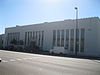 | September 27, 2007 (#07000996) | 443 S. Raymond Ave. 34°08′16″N 118°08′59″W / 34.1379°N 118.1496°W / 34.1379; -118.1496 (Royal Laundry Complex) | |
| 115 | Sara-Thel Court |  | July 11, 1983 (#83001192) | 618-630 S. Marengo Ave. 34°08′06″N 118°08′41″W / 34.135°N 118.1447°W / 34.135; -118.1447 (Sara-Thel Court) | |
| 116 | Singer Building |  | May 16, 1985 (#85001066) | 16 S. Oakland Ave. and 520 E. Colorado Blvd. 34°08′44″N 118°08′22″W / 34.1456°N 118.1395°W / 34.1456; -118.1395 (Singer Building) | |
| 117 | Ernest W. Smith House |  | January 14, 1988 (#87002397) | 272 S. Los Robles Ave. 34°08′28″N 118°08′27″W / 34.1411°N 118.1409°W / 34.1411; -118.1409 (Ernest W. Smith House) | |
| 118 | Southern California Sanitarium Historic District | 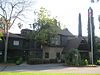 | April 17, 2013 (#13000160) | 2900 E. Del Mar Blvd. 34°08′30″N 118°05′28″W / 34.1417°N 118.0910°W / 34.1417; -118.0910 (Southern California Sanitarium Historic District) | |
| 119 | South Marengo Historic District |  | June 2, 1982 (#82002199) | S. Marengo Ave. 34°08′12″N 118°08′42″W / 34.1367°N 118.145°W / 34.1367; -118.145 (South Marengo Historic District) | |
| 120 | Space Flight Operations Facility |  | October 3, 1985 (#85002814) | Jet Propulsion Laboratory 34°12′04″N 118°10′25″W / 34.2011°N 118.1736°W / 34.2011; -118.1736 (Space Flight Operations Facility) | |
| 121 | Storrier-Stearns Japanese Garden |  | February 15, 2005 (#05000050) | 270 Arlington Dr. 34°07′41″N 118°09′21″W / 34.1280°N 118.1557°W / 34.1280; -118.1557 (Storrier-Stearns Japanese Garden) | |
| 122 | Stoutenburgh House |  | November 25, 1980 (#80000814) | 255 S. Marengo Ave. 34°08′28″N 118°08′42″W / 34.1411°N 118.145°W / 34.1411; -118.145 (Stoutenburgh House) | |
| 123 | Stuart Company Plant and Office Building |  | October 20, 1998 (#94001326) | 3360 E. Foothill Blvd. 34°08′57″N 118°04′49″W / 34.149167°N 118.080278°W / 34.149167; -118.080278 (Stuart Company Plant and Office Building) | Currently a condominium |
| 124 | Toad Hall | Upload image | December 4, 2023 (#100009582) | 353 Anita Drive 34°08′05″N 118°10′41″W / 34.1348°N 118.1781°W / 34.1348; -118.1781 (Toad Hall) | |
| 125 | Twenty-Five-Foot Space Simulator | 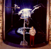 | October 3, 1985 (#85002812) | Jet Propulsion Laboratory 34°12′10″N 118°10′22″W / 34.202778°N 118.172778°W / 34.202778; -118.172778 (Twenty-Five-Foot Space Simulator) | |
| 126 | Villa Verde |  | September 13, 1984 (#84000896) | 800 S. San Rafael 34°07′52″N 118°10′06″W / 34.131149°N 118.168389°W / 34.131149; -118.168389 (Villa Verde) | |
| 127 | Vista del Arroyo Hotel and Bungalows |  | April 2, 1981 (#81000157) | 125 S. Grand Ave. 34°08′38″N 118°09′43″W / 34.143866°N 118.161864°W / 34.143866; -118.161864 (Vista del Arroyo Hotel and Bungalows) | Currently the Richard H. Chambers Courthouse, U.S. Court of Appeals for the 9th Circuit |
| 128 | Henry A. Ware House |  | June 15, 2004 (#04000015) | 460 Bellefontaine St. 34°07′53″N 118°09′36″W / 34.131336°N 118.160085°W / 34.131336; -118.160085 (Henry A. Ware House) | |
| 129 | Washington Court |  | November 15, 1994 (#94001316) | 475 E. Washington Blvd. 34°10′09″N 118°08′27″W / 34.169179°N 118.140796°W / 34.169179; -118.140796 (Washington Court) |
Former listings
| [4] | Name on the Register | Image | Date listed | Date removed | Location | City or town | Description |
|---|---|---|---|---|---|---|---|
| 1 | Neighborhood Church | Upload image | April 10, 1974 (#74002272) | August 14, 1974 | Pasadena Ave. and California Blvd. | Demolished July 27, 1974 for construction of Interstate 710.[8] | |
| 2 | Pasadena Athletic and Country Club | Upload image | November 11, 1977 (#77001545) | 1978 | SE corner of E. Green St. and S. Los Robles Ave. | Demolished in 1977 for construction of the Plaza Pasadena shopping mall, which was demolished in 2000.[9] |
See also
Wikimedia Commons has media related to National Register of Historic Places in Pasadena, California.
 Los Angeles portal

- List of National Historic Landmarks in California
- National Register of Historic Places listings in California
- California Historical Landmarks in Los Angeles County, California
References
- ^ The latitude and longitude information provided in this table was derived originally from the National Register Information System, which has been found to be fairly accurate for about 99% of listings. Some locations in this table may have been corrected to current GPS standards.
- ^ Searching for listings in Pasadena in the National Register Focus database returns a different count because it includes boundary adjustments to historic districts and only includes listings through March 2010.
- ^ National Park Service, United States Department of the Interior, "National Register of Historic Places: Weekly List Actions", retrieved June 7, 2024.
- ^ a b Numbers represent an alphabetical ordering by significant words. Various colorings, defined here, differentiate National Historic Landmarks and historic districts from other NRHP buildings, structures, sites or objects.
- ^ "National Register Information System". National Register of Historic Places. National Park Service. January 23, 2007.
- ^ The eight-digit number below each date is the number assigned to each location in the National Register Information System database, which can be viewed by clicking the number.
- ^ Moruzzi, Peter (March 2013). "National Register of Historic Places Multiple Property Documentation Form: The Case Study House Program: 1945-1966" (PDF). National Park Service. Retrieved August 2, 2013.
- ^ Preservation News, October 1974
- ^ "Hometown Pasadena - an online magazine of architecture and interior design, which presents interesting ideas also like the latest trends in the field of modern construction, furnishing, decoration, designer real estate and kitchen equipment". 25 September 2023.
- v
- t
- e
- List of U.S. National Historic Landmarks by state:
- Alabama
- Alaska
- Arizona
- Arkansas
- California
- Colorado
- Connecticut
- Delaware
- Florida
- Georgia
- Hawaii
- Idaho
- Illinois
- Indiana
- Iowa
- Kansas
- Kentucky
- Louisiana
- Maine
- Maryland
- Massachusetts
- Michigan
- Minnesota
- Mississippi
- Missouri
- Montana
- Nebraska
- Nevada
- New Hampshire
- New Jersey
- New Mexico
- New York
- North Carolina
- North Dakota
- Ohio
- Oklahoma
- Oregon
- Pennsylvania
- Rhode Island
- South Carolina
- South Dakota
- Tennessee
- Texas
- Utah
- Vermont
- Virginia
- Washington
- West Virginia
- Wisconsin
- Wyoming
 National Register of Historic Places portal
 Category


