Ankazobe (district)
District in Analamanga, Madagascar
18°31′S 47°11′E / 18.517°S 47.183°E / -18.517; 47.183 Madagascar
 (2018)
108
Ankazobe is a district of Analamanga in Madagascar.[2][3]
Communes
The district is further divided into 15 communes:
- Ambohitromby
- Ambolotarakely
- Andranomiely Sud
- Ankazobe
- Antakavana
- Antotohazo
- Fiadanana
- Fihaonana
- Kiangara
- Mahavelona
- Mangasoavina
- Marondry
- Miantso
- Talata-Angavo
- Tsaramasoandro
Infrastructure
- Route Nationale 4 from Antananarivo to Mahajanga.
- Route d'Interet Provinciale 40T (RIP 40T) from the RN 4/Ankazobe to Talata-Angavo
Nature reserves
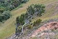
The Ambohitantely Special Reserve is situated at 30 km in the North-East of the town of Ankazobe. It is situated on the territory of the municipalities of Antakavana and Ambolotarakely.[4]
-
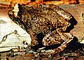 Anodonthyla vallani, a threatened frog species
 -
 Schizolaena tampoketsana a species native to Ankazobe
 -
 Ankazobe
 -
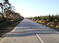 National road 4


References
- ^ Region Analamanga
- ^ REPOBLIKAN’I MADAGASIKARA:Tanindrazana – Fahafahana – Fandrosoana (PDF). MINISTERE DE L’AGRICULTURE, DE L’ELEVAGE ET DE LA PECHE. October 2007. pp. 42–44. Archived from the original (PDF) on 2018-06-12. Retrieved 2018-06-09.
- ^ "Madagascar: Administrative Division". citypopulation. Retrieved 10 June 2018.
- ^ Lemurs of Madagascar
| Authority control databases |
|
|---|
| ||
|---|---|---|
Capital: Antananarivo | ||
| Ambohidratrimo (24) - 105 |  | |
| Andramasina (14) - 106 | ||
| Anjozorobe (18) - 107 | ||
| Ankazobe (15) - 108 | ||
| Antananarivo-Atsimondrano (26) - 102 |
| |
| Antananarivo-Avaradrano (16) - 103 | ||
| Antananarivo-Renivohitra (1) - 101 | ||
| Manjakandriana (23) - 116 | ||
8 districts; 137 communes | ||
 | This Madagascar location article is a stub. You can help Wikipedia by expanding it. |
- v
- t
- e


