List of bridges on the National Register of Historic Places in Maine
This is a list of bridges and tunnels on the National Register of Historic Places in the U.S. state of Maine.[1]
| Name | Image | Built | Listed | Location | County | Type |
|---|---|---|---|---|---|---|
| Androscoggin Swinging Bridge |  | 1892, by 1913, 1936 | January 14, 2004 | Brunswick 43°55′6″N 69°58′26″W / 43.91833°N 69.97389°W / 43.91833; -69.97389 (Androscoggin Swinging Bridge) | Cumberland | Suspension bridge |
| Arch Bridge |  | c. 1857 | July 7, 2003 | Bristol 43°57′44″N 69°30′35″W / 43.96222°N 69.50972°W / 43.96222; -69.50972 (Arch Bridge) | Lincoln | Stone arch bridge |
| Babb's Bridge |  | 1976 replica of 1864 bridge | September 7, 1972 | Windham 43°45′58″N 70°26′53″W / 43.76611°N 70.44806°W / 43.76611; -70.44806 (Babb's Bridge) | Cumberland | 1864 bridge destroyed by arson in 1973. |
| Bailey Island Cobwork Bridge |  | 1928 | April 28, 1975 | Harpswell 43°44′55″N 69°59′22″W / 43.74861°N 69.98944°W / 43.74861; -69.98944 (Bailey Island Cobwork Bridge) | Cumberland | The only surviving cribstone bridge in the world |
| Bennett Bridge | 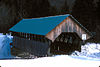 | 1901 | February 16, 1970 | Wilson Mills 44°55′4″N 71°2′21″W / 44.91778°N 71.03917°W / 44.91778; -71.03917 (Bennett Bridge) | Oxford | Paddleford truss |
| Carriage Paths, Bridges and Gatehouses |  | 1919, 1931 | November 14, 1979 | Acadia National Park | Hancock | Gothic arched bridges |
| Churchill Bridge |  | 1797 | March 17, 1994 | Buckfield 44°14′44″N 70°23′10″W / 44.24556°N 70.38611°W / 44.24556; -70.38611 (Churchill Bridge) | Oxford | Stone lintel bridge |
| Grist Mill Bridge |  | c. 1885 | December 27, 1990 | Lebanon 43°23′30″N 70°51′6″W / 43.39167°N 70.85167°W / 43.39167; -70.85167 (Grist Mill Bridge) | York | A non-trussed, timber bridge on stone abutments improved in 1950 and restored in 1993. |
| Hemlock Bridge |  | 1857 | February 16, 1970 | Fryeburg Center 44°4′46″N 70°54′13″W / 44.07944°N 70.90361°W / 44.07944; -70.90361 (Hemlock Bridge) | Oxford | Paddleford truss |
| Lovejoy Bridge |  | 1868 | February 16, 1970 | South Andover 44°35′37″N 70°44′2″W / 44.59361°N 70.73389°W / 44.59361; -70.73389 (Lovejoy Bridge) | Oxford | Paddleford truss |
| New Portland Wire Bridge |  | 1866 | January 12, 1970 | New Portland 44°53′27″N 70°5′37″W / 44.89083°N 70.09361°W / 44.89083; -70.09361 (New Portland Wire Bridge) | Somerset | Possibly the only surviving wire (suspension) bridge in the United States. It has covered, timber framed towers. |
| Porter-Parsonfield Bridge |  | 1876 | February 16, 1970 | Porter 43°47′30″N 70°56′18″W / 43.79167°N 70.93833°W / 43.79167; -70.93833 (Porter-Parsonfield Bridge) | Oxford, York | Paddleford Truss |
| Robyville Bridge |  | 1876 | February 16, 1970 | Corinth 44°56′35″N 68°58′8″W / 44.94306°N 68.96889°W / 44.94306; -68.96889 (Robyville Bridge) | Penobscot | Howe truss System |
| Ryefield Bridge | 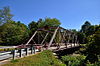 | 1912 | September 24, 1999 | Stuarts Corner 44°8′34″N 70°35′43″W / 44.14278°N 70.59528°W / 44.14278; -70.59528 (Ryefield Bridge) | Cumberland and Oxford | Warren through truss |
| Sunday River Bridge |  | 1872 | February 16, 1970 | Newry 44°29′31″N 70°50′36″W / 44.49194°N 70.84333°W / 44.49194; -70.84333 (Sunday River Bridge) | Oxford | Paddleford truss |
| Thompson's Bridge |  | c. 1808 | March 22, 1991 | Allen's Mills 44°43′36″N 70°0′25″W / 44.72667°N 70.00694°W / 44.72667; -70.00694 (Thompson's Bridge) | Franklin | Stone lintel |
| Two Cent Bridge |  | 1903 | September 20, 1973 | Waterville-Winslow 44°33′3″N 69°37′45″W / 44.55083°N 69.62917°W / 44.55083; -69.62917 (Two Cent Bridge) | Kennebec | Suspension type |
| Watson Settlement Bridge |  | 1911 | February 16, 1970 | Littleton 46°12′36″N 67°48′3″W / 46.21000°N 67.80083°W / 46.21000; -67.80083 (Watson Settlement Bridge) | Aroostook | Howe truss system |
Bridges removed from the register
| Name | Image | Built | Listed | Delisted | Location | County | Type | Notes |
|---|---|---|---|---|---|---|---|---|
| Lowe's Bridge | 1857 | May 12, 1987 | Sangerville | Piscataquis | Long truss system | Lost in flood | ||
| Morse Bridge | 1882 | February 16, 1970 | September 29, 2015 | Bangor 44°48′28″N 68°46′43″W / 44.80778°N 68.77861°W / 44.80778; -68.77861 (Morse Bridge) | Penobscot | Covered bridge | Burned down in the 1980s | |
| New Sharon Bridge |  | 1916 | September 24, 1999 | July 14, 2015 | New Sharon 44°38′16″N 70°0′56″W / 44.63778°N 70.01556°W / 44.63778; -70.01556 (New Sharon Bridge) | Franklin | Pennsylvania thru truss | Torn down in 2014 |
| Smith Bridge |  | 1910 | April 2, 1993 | December 8, 2013 | Houlton 46°10′52″N 67°48′16″W / 46.18111°N 67.80444°W / 46.18111; -67.80444 (Smith Bridge) | Aroostook | 2-Span Warren pony truss | |
| Waldo-Hancock Bridge |  | 1931 | June 20, 1985 | December 8, 2013 | Prospect, Verona 44°33′37″N 68°48′8″W / 44.56028°N 68.80222°W / 44.56028; -68.80222 (Waldo-Hancock Bridge) | Hancock, Waldo | Suspension bridge | Demolished in 2013 |
References
Map all coordinates using OpenStreetMap
Download coordinates as:
- KML
- GPX (all coordinates)
- GPX (primary coordinates)
- GPX (secondary coordinates)
- ^ "National Register Information System". National Register of Historic Places. National Park Service. July 9, 2010.
- v
- t
- e
- Alabama
- Alaska
- Arizona
- Arkansas
- California
- Colorado
- Connecticut
- Delaware
- Florida
- Georgia
- Guam
- Hawaii
- Idaho
- Illinois
- Indiana
- Iowa
- Kansas
- Kentucky
- Louisiana
- Maine
- Maryland
- Massachusetts
- Michigan
- Minnesota
- Mississippi
- Missouri
- Montana
- Nebraska
- Nevada
- New Hampshire
- New Jersey
- New Mexico
- New York
- North Carolina
- North Dakota
- Ohio
- Oklahoma
- Oregon
- Pennsylvania
- Puerto Rico
- Rhode Island
- South Carolina
- South Dakota
- Tennessee
- Texas
- Utah
- Vermont
- Virginia
- Washington
- Washington, D.C.
- West Virginia
- Wisconsin
- Wyoming


