List of bridges on the National Register of Historic Places in Utah
This is a list of bridges and tunnels on the National Register of Historic Places in the U.S. state of Utah.[1]
| Name | Image | Built | Listed | Location | County | Type |
|---|---|---|---|---|---|---|
| Cable Creek Bridge |  | 1932 | 1996-02-16 | Floor of the Valley Road, Zion National Park 37°16′13″N 112°56′19″W / 37.27028°N 112.93861°W / 37.27028; -112.93861 (Cable Creek Bridge) | Washington | NPS Rustic |
| Dewey Bridge |  | 1916 destroyed 2008 | 1984-07-12 | Former routing of SR-128 over Colorado River, Dewey 38°48′43″N 109°18′9″W / 38.81194°N 109.30250°W / 38.81194; -109.30250 (Dewey Bridge) | Grand | |
| Hurricane-LaVerkin Bridge | 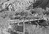 | 1908 | 1995-04-14 | old SR-9 over Virgin River, between Hurricane and La Verkin 37°11′22″N 113°16′13″W / 37.18944°N 113.27028°W / 37.18944; -113.27028 (Hurricane-LaVerkin Bridge) | Washington | |
| Lincoln Highway Bridge |  | 1900 | 1975-05-21 | old Lincoln Highway over Government Creek, Dugway Proving Ground 40°10′58″N 112°55′23″W / 40.18278°N 112.92306°W / 40.18278; -112.92306 (Lincoln Highway Bridge) | Tooele | |
| Murphy Trail and Bridge | 1917 | 1988-10-07 | Sidehill viaduct on Murphy Trail descending from the Island in the Sky district, Canyonlands National Park 38°20′30″N 109°52′30″W / 38.34167°N 109.87500°W / 38.34167; -109.87500 (Murphy Trail and Bridge) | San Juan | ||
| Rockville Bridge | 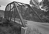 | 1924 | 1995-08-04 | Bridge Road over Virgin River, Rockville 37°9′30″N 113°2′16″W / 37.15833°N 113.03778°W / 37.15833; -113.03778 (Rockville Bridge) | Washington | |
| San Rafael Bridge |  | 1935, 1937 | 1996-06-03 | Buckhorn Draw Road over San Rafael River, southeast of Castle Dale 39°4′52″N 110°39′49″W / 39.08111°N 110.66361°W / 39.08111; -110.66361 (San Rafael Bridge) | Emery | |
| Southern Pacific Railroad: Ogden-Lucin Cut-Off Trestle |  | 1902–1904 | 1972-04-14 | Lucin Cutoff over Great Salt Lake, west of Ogden 41°12′N 112°30′W / 41.200°N 112.500°W / 41.200; -112.500 (Southern Pacific Railroad: Ogden-Lucin Cut-Off Trestle) | Box Elder | |
| Weber River Railroad Bridge |  | 1897 | 2015-04-06 | 0.5 miles (0.80 km) west of Union Station along Exchange Rd. 41°13′N 111°59′W / 41.217°N 111.983°W / 41.217; -111.983 (Weber River Railroad Bridge) | Weber | |
| Zion-Mount Carmel Highway | 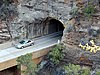 | 1930 | 1987-07-07 | SR-9 through Zion National Park bridges over North Fork Virgin River, Pine Creek (twice), Co-op Creek[2] two tunnels, including the Zion-Mount Carmel Tunnel 37°13′N 112°56′W / 37.217°N 112.933°W / 37.217; -112.933 (Zion-Mount Carmel Highway) | Washington |
References
Map all coordinates using OpenStreetMap
Download coordinates as:
- KML
- GPX (all coordinates)
- GPX (primary coordinates)
- GPX (secondary coordinates)
- ^ "National Register Information System". National Register of Historic Places. National Park Service. July 9, 2010.
- ^ Utah State History: Utah Properties Listed in the National Register of Historic Places Archived 2008-08-21 at the Wayback Machine, updated July 8, 2005, accessed June 2008
- v
- t
- e
- Alabama
- Alaska
- Arizona
- Arkansas
- California
- Colorado
- Connecticut
- Delaware
- Florida
- Georgia
- Guam
- Hawaii
- Idaho
- Illinois
- Indiana
- Iowa
- Kansas
- Kentucky
- Louisiana
- Maine
- Maryland
- Massachusetts
- Michigan
- Minnesota
- Mississippi
- Missouri
- Montana
- Nebraska
- Nevada
- New Hampshire
- New Jersey
- New Mexico
- New York
- North Carolina
- North Dakota
- Ohio
- Oklahoma
- Oregon
- Pennsylvania
- Puerto Rico
- Rhode Island
- South Carolina
- South Dakota
- Tennessee
- Texas
- Utah
- Vermont
- Virginia
- Washington
- Washington, D.C.
- West Virginia
- Wisconsin
- Wyoming


